Saßleben
|
Saßleben
Zasłomjeń City of Calau
Coordinates: 51 ° 45 ′ 33 ″ N , 13 ° 59 ′ 10 ″ E
|
|
|---|---|
| Height : | 70 m above sea level NHN |
| Area : | 15.28 km² |
| Residents : | 188 (Jun. 1, 2020) |
| Population density : | 12 inhabitants / km² |
| Incorporation : | October 26, 2003 |
| Postal code : | 03205 |
| Area code : | 03541 |
Saßleben , Zasłomjeń in Lower Sorbian , is a district of the city of Calau in the Oberspreewald-Lausitz district in southern Brandenburg .
geography
Saßleben is located in Lower Lusatia . The municipality of Kalkwitz and the Dubrau desert are north of the village . The Vetschau district of Koßwig connects to the northeast . To the east are the Calau districts of Reuden and Bolschwitz . The town of Calau and its district of Plieskendorf are located south of Saßleben . In the west the place borders on Mlode .
The districts of Kalkwitz and Reuden belong to Saßleben .
history
Remains of a Slavic castle ramparts in Saßleben indicate early settlement. The place name Saßleben goes back to the Sorbian place name Saslomen and means place that provides good straw . Around the year 1350, a branch of the von Löben family lived in Saßleben , which was widespread in Niederlausitz. In 1911 the Jewish merchant Georg Wertheim acquired the manor and gave it to his wife for the birth of his son. Administratively, the place belonged to the district of Calau . In 1945 the castle burned down, only a few stables remained.
Kalkwitz was incorporated into Saßleben on February 1, 1974 and Reuden on May 1, 1974.
On October 26, 2003, Saßleben was incorporated with Groß Mehßow , Kemmen , Mlode , Bolschwitz and Werchow to Calau.
Population development
| Population development in Saßleben from 1875 to 2002 | |||||||||||||
|---|---|---|---|---|---|---|---|---|---|---|---|---|---|
| year | Residents | year | Residents | year | Residents | year | Residents | year | Residents | year | Residents | year | Residents |
| 1875 | 286 | 1933 | 258 | 1964 | 269 | 1989 | 409 | 1993 | 363 | 1997 | 413 | 2001 | 432 |
| 1890 | 217 | 1939 | 232 | 1971 | 258 | 1990 | 401 | 1994 | 377 | 1998 | 434 | 2002 | 429 |
| 1910 | 253 | 1946 | 393 | 1981 | 481 | 1991 | 388 | 1995 | 382 | 1999 | 421 | ||
| 1925 | 279 | 1950 | 323 | 1985 | 457 | 1992 | 376 | 1996 | 419 | 2000 | 433 | ||
Culture and sights
The park of the burned down castle and the ponds belonging to it were created in the second half of the 18th century. It is about 14 hectares. A boat landing stage and an island pavilion were completed in 1924/1925. At the pavilion there are four caryatids that represent the four seasons. The pavilion is now in the park of the moated castle Fürstlich Drehna .
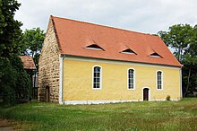
The Saßleben church was built in the 15th century. In 1775 it was rebuilt and the small wooden belfry was probably built. The master miller Johann Friedrich Krüger from Saßleben donated an organ in 1813, but it was replaced by a new one in 1928.
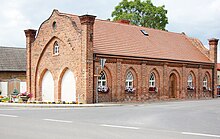
At the entrance to the village on the road to Calau there is a village blacksmith's shop from the first quarter of the 19th century. It is a technical monument. With its neo-Gothic exterior, the industrial building gives it a sacral appearance. The park, the church and the smithy, like an inn and a residential building in Saßleben, are among the architectural monuments in Calau .
Individual evidence
- ↑ Information from the residents' registration office of the city of Calau from June 18, 2020. Excluding Kalkwitz (82 residents) and Reuden (105 residents).
- ↑ Municipalities 1994 and their changes since January 1, 1948 in the new federal states , Metzler-Poeschel publishing house, Stuttgart, 1995, ISBN 3-8246-0321-7 , publisher: Federal Statistical Office
- ^ StBA: Changes in the municipalities in Germany, see 2003
- ↑ Brandenburg Statistics (PDF)
Web links
- Representation of the Saßleben district on the Calau homepage , accessed on August 11, 2009.

