Plieskendorf
|
Plieskendorf
Wjelchna City of Calau
Coordinates: 51 ° 43 ′ 37 ″ N , 13 ° 58 ′ 13 ″ E
|
|
|---|---|
| Height : | 84 m above sea level NHN |
| Residents : | 81 (Jun 1, 2020) |
| Incorporation : | July 15, 1965 |
| Incorporated into: | Verkhov |
| Postal code : | 03205 |
| Area code : | 03541 |
|
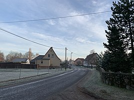
Plieskendorfer Strasse
|
|
Plieskendorf , Wjelchna in Lower Sorbian , is part of Werchow , a district of the city of Calau in the northern part of the Oberspreewald-Lausitz district in southern Brandenburg .
location
Plieskendorf is located in Niederlausitz in the Niederlausitzer Landrücke Nature Park .
The town of Calau and the Calau district of Saßleben are to the northwest and north . From the northeast to the southeast follow the district of Bolschwitz , the Vetschau district of Gahlen and places of the community of Luckaitztal . Plieskendorf borders Werchow in the south-west and the Kemmen district to the west .
history
Local history
The first mention was on December 12, 1570. The mention was made in connection with the manor Raden , both places were in one hand. Plieskendorf was founded as a Zeilendorf with a Vorwerk . The Vorwerk, the current Lindenhof, had a sheep farm and a forestry. The German place name Bleyßkendorf mentioned in 1575 may be traced back to a personal name like Bližk . In 1761 the Lower Sorbian place name Welchna was mentioned . This name is a transformation of wjerchny , which means located above and is related to the neighboring place name Verkhov .
After the Congress of Vienna Plieskendorf came with the entire Lower Lusatia to the Kingdom of Prussia and belonged to the district of Calau . In the middle of the 19th century, the inhabitants cultivated wine on the surrounding hills. Until the beginning of the 20th century, Plieskendorf belonged to the Reuden manor. On April 1, 1900, Plieskendorf was sold to Eugen Richter from Buchwäldchen . After the Second World War, Plieskendorf belonged to the Calau district, newly founded in 1952, and was incorporated into Werchow on July 15, 1965. The place belongs to the church district Niederlausitz . On October 26, 2003 Werchow (with Plieskendorf) was incorporated into the city of Calau with the places Mlode , Groß Mehßow , Kemmen , Bolschwitz and Saßleben .
Population development
| Population development in Plieskendorf from 1875 to 1964 | |||
|---|---|---|---|
| year | Residents | year | Residents |
| 1875 | 102 | 1890 | 118 |
| 1910 | 150 | 1925 | 164 |
| 1933 | 147 | 1939 | 153 |
| 1946 | 228 | 1950 | 222 |
| 1964 | 159 | ||
Economy and Infrastructure
The federal motorway 13 runs west of the village . The Halle – Cottbus and Lübbenau – Kamenz railway lines run through Plieskendorf .
After the rebuilt Buchwäldchen clinker factory went into operation, workers opened up the Plieskendorf clay pit in the early 1950s. In 1953 the first bucket chain excavator was used. The clay was extracted until 1990, at the moment mainly gravel is extracted. The gravel pit is the northernmost find area for Lusatian agates .
Individual evidence
- ↑ Information from the residents' registration office of the city of Calau from June 18, 2020.
- ^ StBA: Changes in the municipalities in Germany, see 2003
- ↑ Brandenburg Statistics (PDF)
- ^ Mineralienatlas - Calau-Plieskendorf , accessed on June 26, 2014.
literature
- Ernst Eichler : The place names of Niederlausitz . VEB Domowina-Verlag, Bautzen 1975.
Web links
- Homepage of the city of Calau - Representation of the Werchow district with Plieskendorf district accessed on November 30, 2009
- Homepage of the city of Calau - representation of the district of Saßleben with the municipality of Reuden accessed on November 30, 2009

