
Sassau (Walchensee)
| Sassau | ||
|---|---|---|
 |
||
| Waters | Walchensee | |
| Geographical location | 47 ° 35 '31 " N , 11 ° 22' 3" E | |
|
||
| length | 367 m | |
| width | 93 m | |
| surface | 2,596 ha | |
| Highest elevation | 814 m above sea level NN | |
| Residents | uninhabited | |
 |
||

Sassau (traditional spelling Saſsau with a long s ) is the only island in the Walchensee in Bavaria . It is 2,596 hectares in size, uninhabited and politically belongs to the municipality and congruent district of Kochel am See in the Bad Tölz-Wolfratshausen district , Bavaria, the center of which is seven kilometers north.
history
The island belonged to the Benediktbeuern monastery court until the secularization in 1803 and was a place of refuge for the local convent in critical times. The members of the monastery stayed there in 1632, when the Swedes invaded during the Thirty Years' War , together with the treasures of the monastery. It also happened during the War of the Spanish Succession . The foundations of former buildings, which Abbot Eliland II had erected there in 1703 and reinforced them with serpentines (long guns) and cannons for defense, date from this time. After 1803 the electoral , from 1806 the royal Bavarian Forstarkar was responsible for the island. During this time, a cooking stove was built on the island by order of Max II . From 1885 the island belonged to the Jachenau Forestry Office as District XX . In 1892 the royal medical officer Dr. Franz von Pfistermeister, son of Franz Seraph von Pfistermeister the island. It remained in the family's possession until it was bought back by the Bavarian State Forestry Administration in 1972. In the 1960s, the Protestant pastor Detlef von Walter, with the permission of the owners, built several log cabins for his family on the island . These were evacuated and demolished in 1972.
geography
location

The island is located in the eastern part of the Walchensee, 210 meters from the eastern shore of the lake Am Steineck . The nearest town isachenbach in the municipality of Jachenau 1.7 km (as the crow flies ) north.
In terms of natural space , Sassau belongs to the main unit of the Kochel Mountains , which, according to the natural division of Germany (according to Meynen / Schmithüsen et al.), Is part of the main unit group Swabian-Upper Bavarian Prealps .
shape
The water depth between the mainland and Sassau is only 15 to 23 meters, which is why the island has been compared to a peninsula . It also represents the eastern border point between the lake parts Altlacher or Obersee in the south and the central main part Weitsee . Sassau and the Steineck form the southern boundary of the Breite Bucht , which extends in the north to the small Buchenort peninsula . The island has a length of 367 meters from west to east and a maximum width of 93 meters from north to south in the west of the island. Sassau has an elongated shape and tapers to the east. The perimeter of the island (shoreline) is approximately 900 meters. Topographically, the island consists of a ridge running from west to east and a flat bank. The banks are undeveloped and have a gravel structure. The island reaches an altitude of 814 meters and thus rises more than 13 meters above the lake level (800.8 meters).
geology
The Walchensee is located in the northern Limestone Alps , a young fold mountain range that is still rising. The lake was created by geological folds and was then glacial overprinted. Mighty carbonate rocks of the Triassic characterize the diverse landscape. Noric limestone layers of the Upper Triassic form the predominant geological formation of the island. As a carbonate sedimentary rock , plate limestone is particularly susceptible to strong chemical weathering . The castable hard lime has low to medium contents of non- carbonates . By karstification has a Karst - plateau formed as an island, the locally by rhätische the layers Koessen formation is superimposed.
Rock humus soils have developed on the karst landscape of the island of Sassau . Rendzina and brown earth -Rendzina are the determining soil types . The formation of Tangelrendzina with organic layers of 30 to 85 centimeters over less than 10 centimeters deep developed mineral soils is a specialty of the island and the limestone Alps. The organic edition is also known as tangel humus and refers to the Austrian soil scientist Walter Kubiëna .
climate
The forest area has a cool, humid climate. The island is to be assigned to the low-mountain mixed forest level. The low-montane level represents a climatic altitude level that is characterized by an optimum of the beech and in which the spruce only plays a subordinate role. The mean annual temperature is only 5.2 ° C. The mean annual precipitation can be classified as high at 1,483 mm. The island's precipitation budget is characterized by a pronounced summer maximum and snowy winters. At times, strong foehn winds from the south occur in the Walchensee area and hit the adjacent south-facing slopes.
Flora and fauna
flora
The island is densely overgrown with trees. A mixed mountain forest, unique in this composition, was able to develop without being disturbed by game browsing . A spruce, fir and beech forest with deciduous trees and yews has established itself as a natural forest community . The dominant main tree species is the common beech (Fagus sylvatica ) with over 50 percent . White fir (Abies alba) and Norway spruce ( Picea abies) are the main tree species with 11 to 20 percent . European larch ( Larix decidua) and sycamore maple ( Acer pseudoplatanus) are found on the island with less than 10 percent. Strong spruce and fir overhangs tower over a dense main beech stand, which is stocky with an underlying layer consisting of multi-stemmed yews and firs. The vegetation consists almost exclusively of shade tree species . In a few areas, acidophilic moss species are found on heavily rotten, former deadwood structures .
Sassau is famous among experts for its yew trees, some of which are more than 500 years old. In addition, some plants that previously grew around the Walchensee now only grow on the island.
On the island, beech forests will develop as potential natural vegetation (pnV) without human intervention .
fauna
The natural habitats of the island offer many birds excellent breeding opportunities and migratory birds a safe winter or migration roost. Thus, the occurrence of Mittelmeermöwe ( Larus michahellis ) is a regional specialty. In 2000, a breed that was first Mediterranean gull species detected. The average hatching rate for 13 broods, the course of which was observed at Walchensee between 2000 and 2006, was 60 percent and was thus below the Bavarian average of 70 percent. In 2015 the breeding site on the island was occupied by eight pairs. The island Sassau is considered the highest breeding site of its kind in Germany.
Protected areas
The island of Sassau has a very high nature conservation value and a great need for ecological protection. Therefore, the near-natural forest area was designated and secured as a protected area of different categories.
Nature reserve
As early as 1978, a 7.85 hectare area was placed under protection as a nature reserve (NSG) with the name Insel Sassau in Walchensee by ordinance (NSG-00108.01). The border of the nature reserve runs around the island at a distance of 50 meters. In addition to the preservation of the typical regional vegetation and the protection of the natural yew population, the protection of endangered water bird species and the observation of the natural regeneration dynamics of fir and beech forests under largely undisturbed conditions are the protection purpose of the nature reserve. Entering the island is prohibited all year round.
Natura 2000 area
The mixed montane beech forests and the shore zones of the island were reported to the European Commission as 3.85 hectares of the 1,438.7 hectare European protected area Jachenau and Extensivwiesen bei Fleck ( FFH area , No. 8434-372 ) . The island's protected forest habitats act as stepping stones in the European Natura 2000 network of protected areas in the alpine region. With the "Bavarian Ordinance on Natura 2000 Areas" of February 19, 2016, the FFH areas Jachenau and Extensivwiesen near Fleck were made legally binding in a joint ordinance.
Landscape protection area
The Walchensee including the shoreline and the alpine mountain landscape adjoining it to the south was designated as a landscape protection area (LSG) Walchensee with a total area of 3,506.76 hectares (LSG00492.01) in 1995.
Natural forest reserve
In addition, the island's mixed montane mountain forest has been protected as a natural forest reserve since 1978 and is not used for forestry or hunting. As a state forest, the area belongs to the Free State of Bavaria. With a size of just 2.8 hectares, the island of Sassau is the smallest of the Bavarian natural forest reserves.
photos

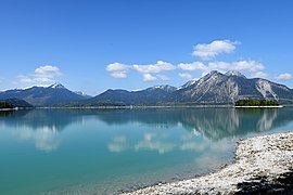
Longitudinal view with the Ester Mountains in the background

Island with the 1,731 meter high Herzogstand in the background

Oblique aerial view of the Walchensee with the island and the Niedernacher Bay

Detailed view of the island with the 1,840 meter high Simetsberg in the background
Lake and island with Herzogstand, Fahrenbergkopf and Simetsberg


.jpg)


See also
Web links
Individual evidence
- ↑ [1]
- ↑ Map of the main natural space units and natural space units in Bavaria. Bavarian State Office for the Environment, accessed on May 4, 2019 .
- ↑ Kochel Mountains. Bavarian State Office for the Environment, 2006, accessed on May 5, 2019 .
- ↑ Alois Geistbeck: The South Bavarian and North Tyrolean lakes. In: Journal of the German and Austrian Alpine Association, year 1885, Volume XVI, pp. 334-354 , here p. 342
- ↑ Edwin Fels: Depth map of the Walchensee (1928)
- ↑ Cornelia Oelwein: The history of the Walchensee and its fishing . Ed .: Martin Boehm. Edition Alpenblick & Seenland, Munich 2010, ISBN 978-3-9813813-0-6 , p. 13 .
- ↑ Measurement on Google Earth
- ↑ Northern Limestone Alps. Bavarian State Office for the Environment, 2007, accessed on May 5, 2019 .
- ↑ 2401 Walchensee and Jachenauer Vorberge. In: landscape profile. Federal Agency for Nature Conservation, March 1, 2012, accessed on May 5, 2019 .
- ↑ Northern Limestone Alps: Permian to Upper Triassic. In: Geological overview of Bavaria. Bavarian State Office for the Environment, October 2010, accessed on May 5, 2019 .
- ^ Geological map of Bavaria 1: 500,000. In: BayernAtlas Geology. Bavarian State Office for the Environment, accessed on May 4, 2019 .
- ↑ a b c d e Jörg Ewald1, Udo Endres: Forest vegetation of the Sassau in Walchensee: Comparison of natural forest and commercial forest, island and peninsula. Faculty of Forest and Forestry at Weihenstephan-Triesdorf University of Applied Sciences, 2015, accessed on May 4, 2019 .
- ↑ Digital geological map of Bavaria 1: 25,000 (dGK25). In: UmweltAtlas Geologie. Bavarian State Office for the Environment, January 9, 2019, accessed on May 4, 2019 .
- ↑ Overview soil map of Bavaria 1: 25,000. In: BayernAtlas. Bavarian State Office for the Environment, accessed on May 4, 2019 .
- ↑ Alexander Stahr: Soils of the Northern Limestone Alps. In: Ahabc.de. Retrieved May 5, 2019 .
- ↑ W. Klian, F. Müller, F. Starlinger: The forest growth areas of Austria: A natural area structure according to forest ecological aspects. Federal Forest Research Institute, Forest Research Center, 1993, accessed on May 11, 2019 .
- ↑ a b c d e Profile of the Sassau Natural Forest Reserve. In: Database of natural forest reserves in Germany. Information and Coordination Center for Biological Diversity (IBV) / Federal Office for Agriculture and Food (BLE), June 28, 2007, accessed on May 4, 2019 .
- ^ Manfred Schmidt: Stream and inland lake islands in Germany. Grin Verlag, 2008, ISBN 978-3-638-95278-1 , page 22
- ↑ Overview of the natural forest reserves in Bavaria. Bavarian State Institute for Forests and Forestry / Bavarian State Ministry for Food, Agriculture and Forests (StMELF), accessed on May 4, 2019 .
- ↑ a b c Nature conservation concept for the Bad Tölz forestry company. Bayerische Staatsforsten AöR, December 2017, accessed on May 4, 2019 .
- ^ Website of the Walchensee
- ↑ Dietmar Walter: Breeding attempt of the Mediterranean seagull Larus [m.] Michahellis at Forggensee (Lkr. Ostallgäu, Bavaria). In: Ornithologischer Anzeiger, 46, 2007. Ornithologische Gesellschaft Bayern, 2007, accessed on May 4, 2019 .
- ↑ Kilian Weixler, Hans-Joachim Fünfstück, Sebastian Biele: Seltene Brutvögel in Bayern 2014-2015 / 5th report of the Working Group on rare breeding birds in Bavaria. In: OTUS 8 (2016). Otus eV - Association for Field Ornithology in Bavaria, 2016, accessed on May 5, 2019 .
- ↑ Christoph Moning: Settlement and spreading history of the Mediterranean seagull Larus [m.] Michahellis in Bavaria - results from the work of the Bavarian Avifaunistic Commission. In: Bavarian Avifaunistic Commission (BAK), Volume 4, Issue 1, pp. 23-34, August 2007. Ornithological Society in Bavaria eV, August 2007, accessed on May 4, 2019 .
- ↑ Ordinance on the nature reserve “Insel Sassau im Walchensee”. In: Regulation. Bad Tölz-Wolfratshausen district office, April 17, 1981, accessed on May 4, 2019 .
- ↑ 8434-372 Jachenau and extensive meadows near Fleck (FFH area). In: Profiles of the Natura 2000 areas. Federal Agency for Nature Conservation, June 5, 2018, accessed on May 5, 2019 .
- ↑ a b Fauna-Flora-Habitat areas. In: BayernAtlas. Bavarian State Office for the Environment, February 19, 2016, accessed on May 5, 2019 .
- ↑ Landscape protection areas. In: BayernAtlas. Bavarian State Office for the Environment, accessed on May 4, 2019 .
- ↑ Ulrike Hanning: Green List of Landscape Protection Areas in Upper Bavaria. Bavarian State Office for the Environment, December 31, 2017, accessed on May 4, 2019 .
- ^ LSG "Walchensee" in Germany. In: ProtectedPlanet. United Nations Environment Program, World Conservation Monitoring Center (UNEP-WCMC), accessed May 4, 2019 .
- ↑ Protected planet: Insel Sassau.Retrieved on February 25, 2016.
