
Scheffau (municipality of Scheffau)
|
Scheffau am Tennengebirge (locality) locality ( capital of the municipality ) cadastral community Scheffau |
|||
|---|---|---|---|
|
|||
| Basic data | |||
| Pole. District , state | Hallein (HA), Salzburg | ||
| Judicial district | Hallein | ||
| Pole. local community | Scheffau am Tennengebirge | ||
| Coordinates | 47 ° 34 '44 " N , 13 ° 13' 56" E | ||
| height | 490 m above sea level A. | ||
| Residents of the village | 1146 (January 1, 2020) | ||
| Building status | 304 (2001) | ||
| Area d. KG | 42.03 km² | ||
| Post Code | 5440 Scheffau am Tennengebirge | ||
| Statistical identification | |||
| Locality code | 13654 | ||
| Cadastral parish number | 56219 | ||
| Counting district / district | Scheffau am Tennengebirge (50 212 000) | ||
 Scheffau seen from Mehlstein , into the valley, behind Klausgraben , Roadberg and already the Gosaukamm on the Dachstein |
|||
| Source: STAT : index of places ; BEV : GEONAM ; SAGIS | |||

Scheffau am Tennengebirge is a place in the Lammertal in the state of Salzburg as well as the capital , locality and cadastral community (Scheffau) of the municipality of Scheffau am Tennengebirge in the Hallein district (Tennengau) .
geography
Scheffau is located some 25 kilometers southeast of Salzburg and 14 southeast of Hallein , and is in the lowest Lammertal between Tennengebirge Northern Slope and Black Mountain ( 1584 m above sea level. A. ), who has to Osterhorngruppe the Salzburg Limestone Alps and the Salzkammergut Mountains expected becomes. The location forms the central area of the community.
Scheffau is not a place in the true sense of the word, but extends over about 6 kilometers in a valley basin along the Lammer. The location mainly comprises the villages of Unterscheffau , a group with the Ulrichskirche (historic main town), the village of Rabenstein (the only village in the municipality) and the Rotte Griesau , then somewhat separated from the local area of Heuberg and Oberscheffau , which are scattered Houses with the Rotten Bernhof and Engelhardt , the hamlet Winklau , and the scattered settlement Wieser .
To the east the valley narrows to the Klausgraben , which can only be traversed on foot , but the Lammer breaks into this basin from the north, the bottleneck is the Lammeröfen , which the Lammertalstrasse (B 162) overcomes with the pass at Purgstall . This situation arises from the pre-group of the Tennengebirge with Roadberg and Fichtlhofberg embedded in the Lammertal .
The cadastral community Scheffau (and also the local area) includes not only the localities of Scheffau but also Purgstall , as well as the entire southern mountain area in the Tennengebirge up to the Wieselsteinen , Hochwieskogel and Scheiblingkogel , then in the east over the Roadberg and in the north on the Schwarzen Berg.
| Kellau (O, KG, Gem. Kuchl ) | Voregg (O, KG) | Weitenau (O, KG) |
| Obergäu (O, KG, Gem.Golling adS ) |
.svg)
|
Wallingwinkl (O) |
|
∗
Schlaming (O) Dorfwerfen (KG) (both in the parish of Pfarrwerfen , district of St. Johann / Pongau ) |
Weng (O) Werfenweng (KG) (both in Werfenweng , district of St. Johann / Pongau ) |
Unterberg (O, KG, Gem. Abtenau ) |
history
The wooded Scheffau came in 1130 through a donation by the Archbishop Konrad I of the Salzburg cathedral chapter .
Scheffau was first mentioned in a document as a Scheffawe in 1249. The -au name describes the widening of the valley. The first Ulrichskirche probably also dates from this time , as the mother parish for the whole of Lammertal, it was known as a pilgrimage church . Today the church is a branch of Golling ( Deanery Hallein ), while the inner Lammertal, i.e. also the rest of the Schaffau municipality, is looked after by Abtenau .
Culture and sights
- Filial church of St. Ulrich
- Lammerklamm , natural monument
- Scheffauer mill trail
- Winnerfall with cave, on the Schwarzerbach (Schwarzenbach)
The Tennengebirge is a large nature reserve.

Unterscheffau - St. Ulrich Church
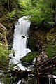
Schwarzenbach, highest level
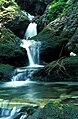
Idyll on the Schwarzenbach


proof
- 56219 - Scheffau am Tennengebirge. Community data, Statistics Austria .

Cadastral communities: Scheffau | Voregg | Weitenau
Locations: Scheffau am Tennengebirge | Voregg | Wallingwinkl | Weitenau
Villages:
Rabenstein |
Hamlet:
Buchegg •
Haselbach •
Kronreif •
Lienbachschmied •
Schilchegg •
Siller •
Walling •
Winklau |
Rotten:
Aschner •
Baumgartner •
Bernhof •
Engelhar [d] t •
Griesau •
Haarberg •
Unterscheffau |
Scattered houses:
Bähmel •
Brunnberger •
Etz •
Oberscheffau •
Purgstall •
Riersberg •
Schönau •
Schönleiten •
Voregg-Moosegg •
Wieser
Other locations:
Bachbauer •
Gypsum mine •
Heuberg •
Leo-Roedel-Hütte •
Moosegg •
Roßberghütte •
Stefan-Schatzl-Hütte
Counting district: Scheffau am Tennengebirge