
Sigmarszell
| coat of arms | Germany map | |
|---|---|---|

|
Coordinates: 47 ° 35 ' N , 9 ° 46' E |
|
| Basic data | ||
| State : | Bavaria | |
| Administrative region : | Swabia | |
| County : | Lindau (Lake Constance) | |
| Management Community : | Sigmarszell | |
| Height : | 482 m above sea level NHN | |
| Area : | 16.01 km 2 | |
| Residents: | 2974 (Dec. 31, 2019) | |
| Population density : | 186 inhabitants per km 2 | |
| Postcodes : | 88138, 88175 | |
| Primaries : | 08382, 08388, 08389 | |
| License plate : | LI | |
| Community key : | 09 7 76 126 | |
| Community structure: | 30 parish parts | |
| Address of the municipal administration: |
Hauptstrasse 28 88138 Sigmarszell |
|
| Website : | ||
| Mayor : | Jörg Agthe ( CSU / Free Citizenship ) | |
| Location of the municipality of Sigmarszell in the district of Lindau (Lake Constance) | ||
  |
||


Sigmarszell ( Sigmarszöll in western Allgäu ) is a municipality in the Swabian district of Lindau (Lake Constance) and the seat of the Sigmarszell administrative community .
geography
location
Sigmarszell is located on the edge of the Westallgäu landscape, about seven kilometers from Lake Constance , with the following districts : Bösenreutin, Niederstaufen, Sigmarszell.
The Leiblach , which separates Sigmarszell from the Austrian state of Vorarlberg , has a length of 14 km and was first mentioned in the year 802 as "Luibilunache".
Neighboring communities
| Weißensberg | Hergensweiler | Opfenbach |
| Lindau (Lake Constance) |
.svg)
|
Scheidegg |
| Hörbranz | Hohenweiler | Möggers |
Community structure
The municipality has 30 officially named parts of the municipality (the type of settlement is given in brackets ):
|
|
|
The wastelands of Greit and Immenmühle are not officially named parts of the municipality.
- The Niederstaufen part of the municipality is a small village with around 800 inhabitants, ten kilometers from Lake Constance. The Catholic village church is dedicated to Saints Peter and Paul. TSV Niederstaufen uses the community sports grounds. Until the end of the 2005/2006 school year, the Niederstaufen children in their first two years were able to attend the village school across from the church. This branch of the Association School Weißensberg has since been closed. Several handicrafts and retail businesses and eleven full-time agricultural businesses represent the economic basis of Niederstaufen. Sights are the newly restored classical church and the rectory. From the original six restaurants, only one remains in Niederstaufen.
- The part of the municipality Bösenreutin borders directly on the Lake Constance city of Lindau. The center of Bösenreutin is the village square where the maypole is set up every year on the night of May 1st . There are signs with pictures of various trades on the maypole, as well as the coat of arms of Bösenreutin. There are a number of important buildings around the village square: the Catholic church with cemetery, the former school (today the music school and the parish hall are located there), a country inn and the fire station. For several years there has been a playground behind the church.
- Schlachters is the largest part of the community. The municipal administration has its seat here. A bank branch of the Sparkasse Memmingen-Lindau-Mindelheim and one of the Raiffeisen-BodenseeBank are represented there. The former fruit growing school Schlachters is as a test station for fruit growing Schlachters a branch of the university Weihenstephan-Triesdorf .
history
At Umgangs and Waldburg (both near Niederstaufen) and Burgstall, there were remains of Roman burgi , tower-like buildings that were built to strengthen the border fortifications between the forts at a distance of about one and a half to two kilometers with an almost square base area of ten to twelve meters on a side .
Around 800 AD, the St. Gallen monastery founded three parishes in the Lindau area, one of which was Sigmarszell.
The former office of the Free Imperial City of Lindau was awarded to the Princes of Bretzenheim as part of the newly formed Principality of Lindau in the main Imperial Deputation in 1803. They exchanged it with Austria in 1804. Since the peace treaties of Brno and Pressburg in 1805, the place has belonged to Bavaria.
Sigmarszell got its name from Sigmar, a serf farmer who absolutely wanted to become a pastor. But as a serf peasant he could not do that. However, his mistress let him go, so he could fulfill his wish and become a pastor. He helped St. Gallus introduce Christianity. Sigmar lived in a cell, therefore: Sigmar's cell. Today there is a church in Sigmarszell in honor of St. Gallus.
At the end of the Second World War, the small Biesings concentration camp external command of the Dachau concentration camp was located in Biesings near Schlachters . The prisoners were later transferred to the Lochau satellite camp.
On January 1, 1972, the three former communities of Bösenreutin, Sigmarszell and Niederstaufen merged to form the new community of Schlachters. On February 8, 1974, the municipality of Schlachters was officially renamed Sigmarszell .
Population development
Between 1988 and 2018 the municipality grew from 2,264 to 2,947 by 683 inhabitants or by 30.2%.
Municipal council
Election 2014:
- FBS (Free Citizenship Sigmarszell): 7 seats
- WG BSN (Voting Association Bösenreutin-Sigmarszell-Niederstaufen): 7 seats
The chairman of the municipal council is 1. Mayor Jörg Agthe (FBS). He was elected to succeed Walter Matzner in March 2014.
coat of arms
The coat of arms of the municipality of Sigmarszell, assigned in 1966, is divided into gold and silver. At the top it shows a red armored black bear growing out of the dividing line with a black tree on its shoulder, at the bottom a green linden leaf.
Culture and sights

Buildings
- St. Gallus Church: The choir and nave of this church are from 1710, the tower substructure dates from the Middle Ages.
- Grünschönstein castle ruins: Only the ring moat remains of this medieval castle of the Lords of Schönstein in Schlachters. The castle at Häbholz (today Heimholz) was also called "Noble Castle". It was destroyed by the Lindau family in 1378. According to a legend, treasure is said to be buried under the castle stables.
- St. Wendelin's Catholic Chapel on the Kinberg Plateau, rectangular building with a three-sided end, 1698; with equipment.
Hiking trails
In 2004 the Zellersteg was rebuilt, which leads over the Leiblach (state border) to Hohenweiler (Austria). The bridge attracts many visitors to go for a walk, walk or cycle. From Niederstaufen there are hiking trails in all directions; particularly beautiful routes lead through the Leiblachtal . The Leiblach River separates Niederstaufen from the neighboring municipality of Hergensweiler and flows into Lake Constance. Another hiking trail leads through the forest to Dornach. In addition, the Way of St. James leads directly through Niederstaufen.
traffic
The Schlachters station is on the last section of the Bavarian Allgäu Railway, opened in 1853 . Since the 1980s it has only served as a depot without passenger traffic. At the Sigmarszell junction of the A 96 , the federal road 31 to Breisach begins .
photos

B 308 at Geislehen

View over the Leiblachtal to Lake Constance

Niederstaufen, church

Niederstaufen - View from the Waldberg
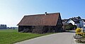
Former Lake farm in Thumen


Personalities
- Anton Bertle (1861–1929) was pastor in Sigmarszell, author of a community chronicle and founder of the Schlachters energy cooperative.
- Norbert Jacques (1880-1954) was one of Luxembourg originating writer . From 1920 until his death in 1954 he lived on Gut Adelinenhof in Thumen, a district of the Schlachters community. From 1945 until after the Second World War he was mayor of this municipality. He is buried there. Since there is no longer a tombstone, a memorial plaque in the cemetery at St. Gallus' church commemorates him; a cul-de-sac in the Thumen district is also named after him.
Web links
- Entry on the coat of arms of Sigmarszell in the database of the House of Bavarian History
Individual evidence
- ↑ "Data 2" sheet, Statistical Report A1200C 202041 Population of the municipalities, districts and administrative districts 1st quarter 2020 (population based on the 2011 census) ( help ).
- ↑ new mayor ( memento of the original from August 26, 2014 in the Internet Archive ) Info: The archive link was automatically inserted and not yet checked. Please check the original and archive link according to the instructions and then remove this notice.
- ^ Community Sigmarszell in the local database of the Bayerische Landesbibliothek Online . Bayerische Staatsbibliothek, accessed on August 18, 2019.
- ↑ Experimental station for fruit growing butcher ( Memento of the original from October 18, 2014 in the Internet Archive ) Info: The archive link was automatically inserted and not yet checked. Please check the original and archive link according to the instructions and then remove this notice. accessed on October 14, 2014
- ↑ The Romans on Lake Constance and Allgäu . P. 13–16, here P. 14. In: Werner Dobras: Chronologie des Landkreis Lindau . Verlag W. Eppe, Bergatreute 1985, ISBN 3890890040
- ↑ The external commandos of the Dachau concentration camp on Lake Constance ( Memento of the original from June 28, 2007 in the Internet Archive ) Info: The archive link has been inserted automatically and has not yet been checked. Please check the original and archive link according to the instructions and then remove this notice.
- ^ Wilhelm Volkert (ed.): Handbook of Bavarian offices, communities and courts 1799–1980 . CH Beck, Munich 1983, ISBN 3-406-09669-7 , p. 513 .
- ↑ Heimatgeschichtliches / Chronik ( Memento of the original from September 28, 2007 in the Internet Archive ) Info: The archive link was inserted automatically and has not yet been checked. Please check the original and archive link according to the instructions and then remove this notice.
- ^ Federal Statistical Office (ed.): Historical municipality directory for the Federal Republic of Germany. Name, border and key number changes in municipalities, counties and administrative districts from May 27, 1970 to December 31, 1982 . W. Kohlhammer, Stuttgart / Mainz 1983, ISBN 3-17-003263-1 , p. 786 .
- ↑ http://www.sigmarszell.de/index.php?id=0,38#fraktion_5
- ↑ http://www.schwaebische.de/region_artikel,-Joerg-Agthe-setzt-sich-knapp-durch-_arid,5607645_toid,461.html
- ↑ Bavarian State Office for Monument Preservation ( page no longer available , search in web archives ) Info: The link was automatically marked as defective. Please check the link according to the instructions and then remove this notice.
- ↑ Roman Dilken: Route Portrait ( Memento of 17 October 2018 Internet Archive ). In: kbs970.de .
Adelberg | Biesings | Evil reverence | Burgstall | Dornach | Egghalden | Emsgritt | Hostage loan | Greit | Haggen | Haggenberg | Hangnach | Heimholz | Hölzler's | Hubers | Immen | Immenmühle | Infang | Barren | Kinbach | Kinberg | Loaf salmon mountain | Leitfritz | Niederstaufen | Butcher | Sigmarszell | Thumen | Tobel | Colloquial | Aries | Funny men | Zeisertsweiler
