
Notch field
|
market community Notch field
|
||
|---|---|---|
| coat of arms | Austria map | |
 |
|
|
| Basic data | ||
| Country: | Austria | |
| State : | Lower Austria | |
| Political District : | Krems-Land | |
| License plate : | KR | |
| Surface: | 47.52 km² | |
| Coordinates : | 48 ° 34 ′ N , 15 ° 19 ′ E | |
| Height : | 579 m above sea level A. | |
| Residents : | 1,574 (January 1, 2020) | |
| Population density : | 33 inhabitants per km² | |
| Postal code : | 3532 | |
| Area code : | 02826 | |
| Community code : | 3 13 36 | |
| NUTS region | AT124 | |
| UN / LOCODE | AT RAS | |
| Address of the municipal administration: |
Notch field 30 3532 notch field |
|
| Website: | ||
| politics | ||
| Mayor : | Gerhard Wandl ( ÖVP ) | |
|
Municipal Council : ( 2020 ) (19 members) |
||
| Location of Rastenfeld in the Krems-Land district | ||
  |
||
| Source: Municipal data from Statistics Austria | ||

Rastenfeld is a market town with 1574 inhabitants (as of January 1, 2020) in the Krems-Land district in Lower Austria .
geography
Rastenfeld is located in the Waldviertel in Lower Austria. The area of the market town covers 47.55 square kilometers. 51.67 percent of the area is forested.
Community structure
The municipality includes the following nine localities (population in brackets as of January 1, 2020):
- Marbach im Felde (205)
- Mottingeramt (142) including Gernitz and Kamphütten
- Niedergrünbach (165)
- Ottenstein (1)
- Peygarten-Ottenstein (468)
- Rastenberg (17)
- Notch field (501)
- Sperkental (66)
- Ornaments (9)
The community consists of the cadastral communities Marbach im Felde, Mottingeramt, Niedergrünbach, Peygarten, Rastenberg, Rastenfeld, Sperkenthal and Zierings.

Neighboring communities
| Zwettl ( Zwettl ) | Pölla ( Zwettl ) | Krumlov |
| Waldhausen ( Zwettl ) |
.svg)
|
Jaidhof |
| Lichtenau in the Waldviertel | Gföhl |
history
Population development
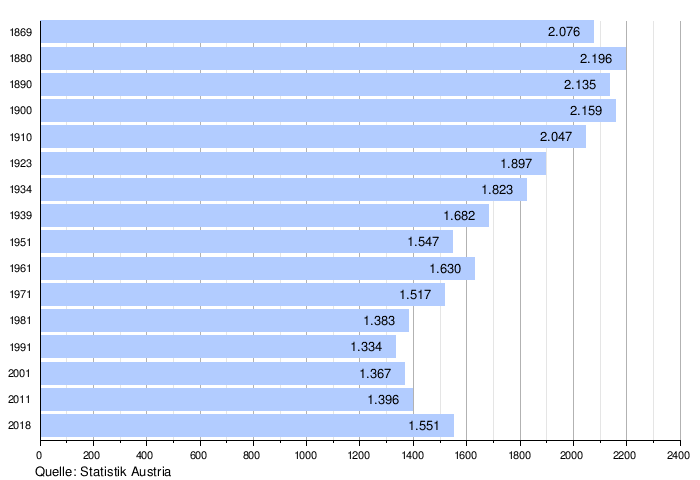
From 1981 to 2011 the population remained almost constant, the birth balance and migration balance were alternately positive and negative.
politics
Mayor of the market town is Gerhard Wandl. With a total of 19 seats, there is the following distribution of mandates in the municipal council: ÖVP 16, SPÖ 3, others no seats.
coat of arms
The heraldic shield, divided in the middle, contains two red scallops next to each other in the upper white field and a white scallop in the lower red field.
Economy and Infrastructure
In 2010 there were 82 agricultural and forestry operations and 78 non-agricultural workplaces in Rastenfeld (as of 2011). 66 people were employed in agriculture, 350 in the secondary economic sector and 299 in the tertiary sector. The employment rate rose from 49.6% in 2001 to 52.3% in 2011.
Regional cooperation
The market town of Rastenfeld is a member of the Kampseen region .
Mills
- Neumühle
1957 was the end of the Neumühle, the mill had to give way to the Ottenstein reservoir . With the move, the mill was also stopped.
- Scoop mill
It stands on the edge of the reservoir and has been preserved to this day.
Personalities
- Franz Ölzelt (1887–1963), politician and clergyman
Attractions
Individual evidence
- ↑ Statistics Austria: Population on January 1st, 2020 by locality (area status on January 1st, 2020) , ( CSV )
- ^ Statistics Austria, A look at the community of Rastenfeld, population development. Retrieved April 1, 2019 .
- ↑ a b Province of Lower Austria, municipality data Rastenfeld. Retrieved April 1, 2019 .
Web links
- Website of the market town of Rastenfeld
- 31336 - grid field. Community data, Statistics Austria .

Aggsbach | Albrechtsberg on the Great Krems | Bergern in the Dunkelsteinerwald | Droß | Dürnstein | Furth near Göttweig | Gedersdorf | Gföhl | Grafenegg | Hadersdorf chambers | Jaidhof | Krumau am Kamp | Langenlois | Lengenfeld | Lichtenau in the Waldviertel | Maria Laach am Jauerling | Mautern on the Danube | Mühldorf | Paudorf | Notch field | Rohrendorf near Krems | Rossatz-Arnsdorf | Schönberg am Kamp | Senftenberg | Pointed | St. Leonhard am Hornerwald | Straß im Straßertal | Stratzing | Weinzierl am Walde | Weißenkirchen in the Wachau
Cadastral communities: Marbach im Felde | Mottingeramt | Niedergrünbach | Peygarten | Rastenberg | Notch field | Sperkenthal | Ornaments
Locations: Marbach im Felde | Mottingeramt | Niedergrünbach | Ottenstein | Peygarten-Ottenstein | Rastenberg | Notch field | Sperkental | Ornaments
Market place: Rastenfeld Villages: Marbach im Felde | Niedergrünbach | Peygarten-Ottenstein | Sperkental Rotten: Rastenberg | Zierings Scattered Houses: Gernitz | Camp huts | Mottingeramt | Ottenstein Other locations: Burg Rastenberg | Schöpfermühle | Ottenstein Castle
Counting district: Rastenfeld | Mottingeramt | Niedergrünbach | Marbach in the field | Peygarten-Ottenstein