Mühldorf (Lower Austria)
|
market community Mühldorf
|
||
|---|---|---|
| coat of arms | Austria map | |
|
|
||
| Basic data | ||
| Country: | Austria | |
| State : | Lower Austria | |
| Political District : | Krems-Land | |
| License plate : | KR | |
| Surface: | 28.43 km² | |
| Coordinates : | 48 ° 22 ' N , 15 ° 21' E | |
| Height : | 360 m above sea level A. | |
| Residents : | 1,288 (January 1, 2020) | |
| Population density : | 45 inhabitants per km² | |
| Postal code : | 3622 | |
| Area code : | 02713 | |
| Community code : | 3 13 30 | |
| NUTS region | AT124 | |
| Address of the municipal administration: |
Markt 13 3622 Mühldorf |
|
| Website: | ||
| politics | ||
| Mayoress : | Beatrix Handl ( ÖVP ) | |
|
Municipal Council : ( 2020 ) (19 members) |
||
| Location of Mühldorf in the Krems-Land district | ||
 View from the district of Ötz towards Mühldorf. Left behind the district Niederranna and right above the Trenninghof. |
||
| Source: Municipal data from Statistics Austria | ||
Mühldorf is a market town in the Krems-Land district in Lower Austria in Austria , with 1288 inhabitants (as of January 1, 2020).
geography
Mühldorf is located in the Spitzer Graben on the edge of the Wachau in the Lower Austrian Waldviertel . The area of the market town covers 28.46 square kilometers. 64.06 percent of the area is forested.
Community structure
The municipality includes the following nine localities (population in brackets as of January 1, 2020):
- Amstall (33)
- Elsarn am Jauerling (150) including On the line
- Mühldorf (319) including Ledertal and Muthstal
- Niederranna (156) with Döpperl
- Oberranna (18) including Unterranna
- Ötz (155) including Wegscheid
- Oetzbach (75)
- Povat (94) including Thurn
- Trandorf (288) including Brandstatt, Örtl, Winkel andlinie
The community consists of the cadastral communities Amstall, Elsarn am Jauerling, Mühldorf, Niederranna, Oberranna, Oetz, Oetzbach, Povat and Trandorf.
Neighboring communities
| Kottes-Purk ( Zwettl ) | Weinzierl | |

|
Pointed | |
| Raxendorf ( Melk ) | Maria Laach |
history
The first Austrian Raiffeisenbank was founded in Mühldorf on December 6, 1886 by the state parliament member Ernst von Vergani with 94 members of the cooperative.
Population development

After 1991 the migration balance became negative and could no longer be balanced out by the birth balance. Since 2001 the birth balance has also been negative.
politics
The municipal council has 19 members.
- With the municipal elections in Lower Austria in 1990, the municipal council had the following distribution: 13 ÖVP and 6 SPÖ.
- With the municipal council elections in Lower Austria in 1995, the municipal council had the following distribution: 10 ÖVP, 6 SPÖ, 2 FPÖ and 1 Team 2000.
- With the municipal council elections in Lower Austria in 2000, the municipal council had the following distribution: 12 ÖVP, 6 SPÖ and 1 FPÖ.
- With the municipal council elections in Lower Austria in 2005 , the municipal council had the following distribution: 12 ÖVP and 7 SPÖ.
- With the municipal elections in Lower Austria in 2010 , the municipal council had the following distribution: 15 ÖVP and 4 SPÖ.
- With the municipal council elections in Lower Austria in 2015 , the municipal council had the following distribution: 14 ÖVP and 5 SPÖ.
- With the municipal council elections in Lower Austria 2020 , the municipal council has the following distribution: 14 ÖVP and 5 SPÖ.
- mayor
- until 2006 Anton Martin (ÖVP)
- 2006–2016 Manfred Hackl (ÖVP)
- since 2016 Beatrix Handl (ÖVP)
Culture and sights
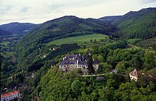
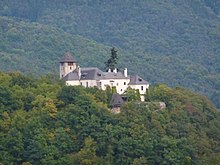
- Oberranna Castle
- Trenninghof
- Prandhof Palace
- Catholic parish church Niederranna hl. Margaretha
- Bakery Museum
economy
The climatic and geological conditions allow viticulture to be carried out in this foothill of the Wachau, away from the Danube . In 2011 there were 110 agricultural and forestry businesses in Mühldorf, 25 of which were full-time businesses. In the secondary economic sector there were 18 companies with 70 employees, more than half of them under construction. In the tertiary sector, 108 companies employed 170 people, most of them in social and public services.
Personalities
- Sons and daughters of the church
- Erwin Hameseder (* 1956), bank manager and brigadier
- Thomas Futterknecht (* 1962), track and field athlete
- People related to the community
- Ernst Vergani (1848–1915), founder of the first Raiffeisenkasse in Austria
- Erne Seder (1925–2006), actress
- Kurt Palm (* 1955), author and director
- Helmut Denk (* 1940), physician and President of the Austrian Academy of Sciences
Web links
- site of the community of Mühldorf in the Wachau
- Entry on Mühldorf in the database of the state's memory for the history of Lower Austria ( Museum Niederösterreich )
- 31330 - Mühldorf (Lower Austria). Community data, Statistics Austria .
Individual evidence
- ↑ Statistics Austria: Population on January 1st, 2020 by locality (area status on January 1st, 2020) , ( CSV )
- ↑ Ernst Vergani's biography (PDF; 7 kB) on the Lower Austrian state government's website, accessed on October 3, 2011
- ↑ 125 years of Raiffeisen: Return to the origin on ORF of October 2, 2011, accessed on October 3, 2011.
- ^ Statistics Austria, A look at the community of Mühldorf, population development. Retrieved April 5, 2019 .
- ^ Result of the municipal council election 1995 in Mühldorf. Office of the Lower Austrian State Government, March 30, 2000, accessed December 28, 2019 .
- ^ Election result of the municipal council election 2000 in Mühldorf. Office of the Lower Austrian State Government, February 4, 2005, accessed December 28, 2019 .
- ^ Election result of the municipal council election 2005 in Mühldorf. Office of the Lower Austrian State Government, March 4, 2005, accessed December 28, 2019 .
- ^ Election result of the municipal council election 2010 in Mühldorf. Office of the Lower Austrian State Government, October 8, 2010, accessed on December 28, 2019 .
- ^ Election results for the 2015 municipal council election in Mühldorf. Office of the Lower Austrian State Government, December 1, 2015, accessed on December 28, 2019 .
- ↑ Results of the municipal council election 2020 in Mühldorf. Office of the Lower Austrian state government, January 26, 2020, accessed on February 29, 2020 .
- ↑ Beatrix Handl new town hall boss tips.at, accessed on October 20, 2016
- ^ Statistics Austria, A look at the community of Mühldorf, agricultural and forestry operations. Retrieved April 5, 2019 .
- ^ Statistics Austria, A look at the community of Mühldorf, workplaces. Retrieved April 5, 2019 .
- ^ Statistics Austria, A look at the community of Mühldorf, employees. Retrieved April 5, 2019 .


