Stackelitz
|
Stackelitz
City of Coswig (Anhalt)
Coordinates: 52 ° 0 ′ 30 ″ N , 12 ° 22 ′ 37 ″ E
|
||
|---|---|---|
| Height : | 108 m above sea level NN | |
| Area : | 17.58 km² | |
| Residents : | 167 (December 1, 2017) | |
| Population density : | 9 inhabitants / km² | |
| Incorporation : | January 1, 2010 | |
| Postal code : | 06868 | |
| Area code : | 034907 | |
|
Location in Saxony-Anhalt |
||
Stackelitz is a district of the city of Coswig (Anhalt) in the district of Wittenberg in Saxony-Anhalt.
geography
The area of Stackelitz in Hohen Fläming , which is 70% forest-covered, extends from the state border with Brandenburg to the headwaters of the southern Nuthe . Stackelitz is located between Dessau-Roßlau and Wiesenburg / Mark in the Fläming Nature Park , declared in 2005 , the information center of which is located in neighboring Jeber-Bergfrieden . At the border with Brandenburg the relief reaches about 160 m above sea level. NN .
history

The first mention of the place comes from the year 1213 and since 1299 Stackelitz belonged to the Cistercian convent Zerbst .
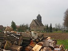
The preserved stone church , which is surrounded by the village cemetery, probably also dates from the 13th century . The four-section church has an apse , choir , nave and a baroque roof turret , the west side of which sits on the massive gable wall. The roof turret replaced the original bell tower, which had been damaged in the Thirty Years War . In 1980 the tower was given a curved dome , which is covered with slate.
On July 1, 2007, the municipality of Stackelitz was incorporated into the Wittenberg district due to a district reform from the former Anhalt-Zerbst district. On January 1, 2010, the previously independent municipality was incorporated into the city of Coswig (Anhalt) together with the municipality of Bräsen .
Schleesen desert
Around two kilometers to the north, at the intersection of Landstrasse 120 and the Roßlau – Wiesenburg railway line, lies the listed Schleesen desert , in which hollows of the former cellar, a well, the - occasionally dried up - village pond and the ruins of another stone church have been preserved. The Schleesen church probably dates from the first half of the 12th century.
Economy and Infrastructure
Established businesses
The largest employer in Stackelitz is the company of the same name, which deals with silviculture, landscaping and horticulture and maintains large forest areas within a radius of 100 kilometers. Furthermore, deer and deer breeding is carried out in a game reserve.
Transport links
The connecting road from Hundeluft on federal road 187a to Wiesenburg / Mark in Brandenburg leads through the district . The Köselitz motorway junction ( A 9 Berlin - Munich) is eleven kilometers from Stackelitz. The railway line from Dessau-Roßlau to Wiesenburg / Mark ( Potsdam ) passes directly to the west of Stackelitz, the next train station is in the neighboring village of Jeber-Bergfrieden .

