
City fortifications Nienburg

The city fortifications of Nienburg were a system of defensive structures for the city of Nienburg / Weser that protected them from attacks from the Middle Ages to the beginning of the 19th century. This included a medieval city wall with city gates as well as ramparts and moats. The Nienburg , built by the Counts of Hoya as a moated castle , was included in the fortification and was later transformed into Nienburg Castle . In the 17th century, Nienburg was expanded into a bastionary fortification and converted into a state fortress of the Principality of Lüneburg and later the Electorate of Hanover . In the Napoleonic Wars, the fortress was in 1806 to French troops and was on Napoleon's command looped . The main remains of the fortifications are ramparts, watercourses and remains of stone and earthworks.
location
Nienburg was built at the intersection of two old trade routes . A road crossed a ford of the Weser and connected Westphalia with the city of Lüneburg . Another road along the Weser connected Bremen with the valley of the Leine . The location on the Meerbach (Steinhuder Meerbach) and the Weser were beneficial for the construction of a fortified place . The river courses in the west and south reduced the need for city fortifications; the waters provided natural protection in the west and south. The course of the sea brook created a triangle with only one unprotected side in the northeast. In the early days of Nienburg, a defense system consisting of a palisade wall with a ditch can be assumed. In the wider area, moor areas in the northeast, such as the Krähenmoor and the Lichtenmoor , restricted an unimpeded approach.
Medieval city fortifications

The emergence of a city fortification in Nienburg is assumed towards the end of the 13th century. The reason could have been the capture of the city by the Minden Bishop Volquin as a result of a dispute with Otto II von Hoya .
There is a presumption that Nienburg had city fortifications early on. It is based on a depiction of a wall with battlements and a gate as well as three towers on a seal from the period between 1215 and 1235. However, there are doubts about such an early fortification by stone walls, since important northern German cities did not have a city wall until later in the 13th century received. It is therefore assumed that the representation on the Nienburg seal merely indicates that it was granted city rights .
No remains of the medieval city fortifications in Nienburg that are visible above ground have survived. Today it is assumed that there are still remains in the ground, but archaeological excavations are required to determine them. Since there are no written sources for the fortification of Nienburg from the Middle Ages, it is only possible to speculate about its type and execution. The only indication of the existence of a medieval city wall is a map from 1634. It shows a wall in front of the city wall, which leads around the city. The map shows four city gates with the Norder, Weser, Mühlen and Leintor gates, which as gate towers could still come from the Middle Ages. The supervision of the city gates was carried out by guards who lived above the gates.
Within the city fortifications on the Weser was a water castle built by the Counts of Hoya , which later became Nienburg Castle . It was partially destroyed during the siege of Nienburg in the Thirty Years' War and completely demolished after the war. The only remnant is the tower built in the first half of the 16th century .
Modern fortress

Shortly after the outbreak of the Thirty Years' War in 1618, there were considerations to strengthen the fortifications. In 1621 the Colonel and Landdrost of the County of Diepholz Cordt Plato found that the defenses were in poor condition. He considered it necessary to repair the parapet and to reinforce the fortifications on the Weser side with palisades . In 1622, Duke Christian von Lüneburg ordered reinforcement of the guards at the gates and on the ramparts as well as six months of provisioning for the city. In 1622 the armament of the ramparts was reinforced with 13 cannons.

In 1625 Danish troops with 3,000 men were billeted in Nienburg after King Christian IV of Denmark was elected colonel of the Lower Saxony Empire . His opponents in the form of the Catholic League had previously successfully besieged the fortress of Hameln . From there, in 1625 the league teams moved with an army of 40,000 men under their general Tilly to Nienburg, where they first took Wölpe Castle and some outer entrenchments laid out by the Danes . After Nienburg had received support from a Danish relief army, Tilly withdrew after a month of siege. There is a legend about the reason for the withdrawal . According to this, a small troop (selected Rott ) is said to have carried out a mock attack through a failure and captured Tilly's flag. The undressing of the chosen Rott is shown today on the facade of a building in the city center of Nienburg.
In 1627 the Catholic League again besieged Nienburg and the Danes gave up the city after the plague broke out. The league players settled in Nienburg and were only driven out in 1635 by troops from Duke Georg von Calenberg .
Swedish troops occupied Nienburg in 1639 and stayed there until 1650. During this time, Nienburg was fundamentally expanded into a fortress in a bastional style, probably by Erik Dahlberg as the most important Swedish fortress builder of the 17th century. He documented the structural condition of the facilities in numerous plans. The building work under the Swedish occupation drove the development of the fortress forward. This resulted in acute-angled bastions , the flanks of which were connected to curtains at right angles , like the

- Bastion Christian Ludwig
- Bastion Georg Wilhelm, also Kuhschanze
- Maypole bastion
- Laboratory bastion
- Holzhofsbastion
- Powder Vault Bastion
- Bastion Sharp Corner
- Mill Bastion
- Mill barrack bastion
The Ravelins were named:
- Nordertorravelin
- Leintorravelin
- Wesertorravelin

In addition, a horn and a crown work were created . The moat was retained. In some areas, a Fausse-Braie was installed , which indicates an orientation towards the Dutch fortress style.
The condition of the fortress towards the end of the Thirty Years' War is documented by a Merian engraving based on the draft of the draftsman Wenzel Hollar from around 1647. Due to the imprecise depiction of the Weser side in the area of the castle and the mills at the mouth of the Meerbach, there are doubts about its reliability the illustration. Another Merian engraving based on the draft by the draftsman Konrad Bruno from 1654, on the other hand, appears more authentic, as its details match the plan of the Swedish fortress builder Erik Dahlberg.
National fortress
After the end of the Thirty Years' War Nienburg mid-17th century was due to its strategic location on a Weser transition from the Principality of Lüneburg to the state fortress expanded. This corresponded to a resolution passed at the Reichstag in Regensburg in 1654 to subordinate the maintenance of the fortresses to the state estates . The fortifications then no longer served exclusively to secure the city, but were expanded under the rulership of Duke Christian Ludwig . The construction work began increasingly from 1655, which can be reconstructed with the help of a site plan from 1662.
Two stones with inscriptions on the former fortress masonry at the confluence of the Meerbach into the Weser bear witness to the construction work in the 1650s and 1660s. On one side of the Meerbach there is a stone with the inscription By God's Grace Christian Ludewig Hertzog zu Braunschweig and Lüneburg Anno Christi 1657 at the height of a restaurant . On the opposite side of the water, a stone of the same name is embedded in the wall, which bears the year 1659. The completion of the expansion work has not been passed down, but it is assumed to be in 1662, as an initial stone embedded in the Christian-Ludwig bastion bears this date.
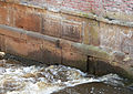
Inscribed stones on the Meerbach for Duke Christian Ludewig with the year 1657 and for a repair from 1747


In the 18th century, the construction work on the fortifications was initially limited to maintenance, as Nienburg had experienced a long period of peace since the Thirty Years' War. However, during the Seven Years' War there was a renewed expansion after the occupation of Nienburg by French troops in 1757. Since the fortifications were in a poor structural condition according to the judgment of the electoral officer Emmerich Otto August von Estorff , the Hanoverian fortress builder Georg Friedrich Dinglinger was ordered to Nienburg in 1759 . He arranged the repair of banquets and the parapet as well as the erection of palisades. In 1761, the military theorist Count Wilhelm von Schaumburg-Lippe examined the fortress and made suggestions for modernization. This led to the construction of emergency casemates, which were built in wood and earth instead of brick, and to work on the external works on the north side.
In 1779 there was the first indication of a razing of the fortifications through a note from the prince to the war chancellery. Nienburg should not receive any further financial support as a fortress and the fortifications should be removed. A commission under Major General Georg Josua du Plat drew up a report on this in 1779. After the decision to abandon the Nienburg Fortress was passed in 1780, the razing work was carried out in the same year. The Leintorravelin was removed, the breastworks removed, the cannons withdrawn, the fortress buildings sold or rented. The razing only covered parts of the fortification, while the main wall around Nienburg with its bastions was preserved.

Preserved lower masonry of the acute-angled Christian-Ludwig bastion on the Weser

Fortress wall with the Christian-Ludwig bastion
Engraved stone of the Christian-Ludwig bastion with the initials "C L" for Duke Christian Ludwig and the year 1662


Final phase of the fortress and razing
In 1803, during the Napoleonic Wars, French troops under Édouard Adolphe Mortier entered Kurhannover and occupied Nienburg. During the French occupation, which lasted until 1805, the fortress construction work continued, which at times employed 600 workers a day. After Prussia had entered into an alliance with France, Prussian troops with around 2,000 men moved into Nienburg in 1806. The last work on the fortifications was carried out under her command. A decisive measure was the order of the Nienburg fortress commander Ludwig von Strachwitz to level the gardens and buildings around Nienburg. This was intended to give the cannons a free field of fire and deprive attackers of their cover. As a result of Prussia's defeat in the battle of Jena and Auerstedt , at the end of 1806 Strachwitz town and fortress surrendered without a fight to French troops under Leone Baptiste Dumonceau . 4000 Prussians were taken prisoner by the French. For this Strachwitz 1809 by a military court to four years imprisonment convicted.
The French began razing the fortifications in 1806 . For this purpose, up to 7,000 workers were deployed in a short peak phase; usually there were 200 to 1500. During the measures, which lasted until 1808, the walls and bastions and other fortifications were removed, the fortress terrain leveled and ditches filled in. Military buildings such as powder magazines and barracks were also demolished. Individual components were not completely removed, but remained to some extent as bank reinforcement and flood protection. These include walls of the Christian Ludwig bastion on the Weser, walls at the mouth of the Meerbach in the Weser and the masonry of the old Weser bridge, which was built as the ravelin of the bridgehead on the other bank of the Weser.
The razing, which caused around 18,000 Reichstaler to be spent, was carried out at no cost, as the same amount was collected again through the sale of materials. On the ramparts, avenue trees were planted in two rows, which formed a promenade and some of them are still preserved today. As a result, the walls were transformed into a green belt around the old town. In 1820 the last map of the razed Nienburg Fortress was created. It was made for the civil use of the land.
Loop command
Although the razing began in 1806, opinions differed about the date of the order. It is sometimes assumed that it was issued shortly after the fortress passed to the French in 1806 or 1807. A decree of Napoleon for the razing of the fortresses Hameln and Nienburg from 1808 is handed down. On July 30th 1808 Nienburg reported the completion to France.
literature
- Stefan Amt , Walter Bettauer: Nienburg Fortress. The structural development of the fortifications. Nienburg / Weser 1996, ISBN 3-9802844-5-X ( Online , pdf, 744 kB)
Web links
- Replica of Nienburg Castle within the city fortifications as a diorama
- History of the Schloßplatz with historical illustration