
Umm al-Bawāqī (Province)
| Umm al-Bawāqī | |
|---|---|
  |
|
| Basic data | |
| Country | Algeria |
| Capital | Umm al-Bawāqī |
| surface | 6712 km² |
| Residents | 612,000 (2006 estimate) |
| density | 91 inhabitants per km² |
| ISO 3166-2 | DZ-04 |
Coordinates: 35 ° 53 ' N , 6 ° 58' E
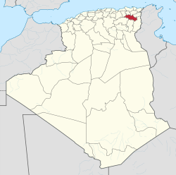
The province of Umm al-Bawāqī ( Arabic ولاية أم البواقي, DMG Wilāyat Umm al-Bawāqī , tamazight ⴰⴳⴻⵣⴷⵓ ⵏ ⵓⵎⵍⴻⴱⵡⴰⵖⵉ Agezdu n Umlebwaɣi ) is a province ( wilāya ) in northeastern Algeria .
The province is located south of the eastern Algerian city of Qusanṭīnâ and covers an area of 6712 km².
Around 612,000 people (2006 estimate) inhabit the province, so the population density is around 91 inhabitants / km².
The capital of the province is Umm al-Bawāqī , the only city with over 100,000 inhabitants is Ain el Beida .
Web links
Adrar | Ain Defla | Ain Temouchent | Algiers | Annaba | Batna | Bechar | Bejaia | Béni Abbès | Biskra | Blida | Bordj Badji Mokhtar | Bordj Bou Arreridj | Bouira | Boumerdes | Chlef | Constantine | Djanet | Djelfa | El Bayadh | El Meniaa | El M'Ghair | El Oued | El Tarf | Ghardaia | Guelma | Illizi | In Guezzam | In Salah | Jijel | Khenchela | Laghouat | Medea | Mila | Mostaganem | M'Sila | Muaskar | Naama | Oran | Ouargla | Ouled Djellal | Relizane | Saida | Sétif | Sidi Bel Abbès | Skikda | Souk Ahras | Tamanrasset | Tebessa | Tiaret | Timimoun | Tindūf | Tipasa | Tissemsilt | Tizi Ouzou | Tlemcen | Touggourt | Umm al-Bawāqī