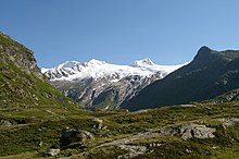
Venediger Höhenweg
The Venediger Höhenweg is a high- altitude hiking trail in the East Tyrolean part of the Austrian Hohe Tauern National Park and is divided into a north and a south section. It extends over approximately 70 kilometers along the Tauern and Virgentals and lies in the glaciated high mountain range of the Grossvenediger .
description
The northern section comprises six stages from the Matreier Tauernhaus to the St. Pöltner Hütte (with a few possible variations), the southern section seven stages from the Ströden hiking car park to the Bichl district in Prägraten am Großvenediger .
Almost without exception, the path leads through alpine and high-alpine terrain at an altitude between 2000 and 3000 m and is partially secured with wire ropes and steel stirrups. A short glacier crossing of the Schlatenkees is only planned in the second stage of the northern section, but it can also be bypassed.
A descent into the valley is possible from all refuges . The southern section extends the high trail on the south side of the Virgental to Matrei in East Tyrol .
Stages of the northern section
| begin | target | Walking time | Summit opportunities | |
|---|---|---|---|---|
| 1 | Matreier Tauernhaus ( 1511 m ) | St. Pöltner Hut ( 2481 m ) | 4-5 h |
Tauernkogel ( 2988 m ; 3.5h) Hörndl ( 2852 m ; 2h) Hochgasser ( 2922 m ; 2h) Messeling ( 2693 m ) |
| 2 | St. Pöltner Hut | New Prague Hut ( 2796 m ) | 7 h |
Großvenediger ( 3657 m ; 3h) crystal wall ( 3329 m ) Rainerhorn black wall high fence |
| 3 | New Prague Hut | Badener Hut ( 2608 m ) | 4 h (via Löbbentörl, 2770 m ) |
Crystal wall ( 3329 m ; 3.5h) Wildenkogel ( 3022 m ; 4 hours) |
| 4th | Badener Hut | Bonn-Matreier Hut ( 2750 m ) | 5 h (via Galtenscharte, 2884 m ) |
Hoher Eichham ( 3371 m ; 3 h) Sailkopf (Säulkopf) ( 3209 m ; 3 h) Rauhkopf ( 3070 m ; 2 h ) |
| 5 | Bonn-Matreier Hut | Johannishütte ( 2121 m ) | 8 h (via Eisseehütte , 2521 m , and Zopetscharte 2958 m ) 8 h (via Eisseehütte, 2521 m , and Sajathütte 2600 m ) |
Großvenediger ( 3657 m ; 4–5 h; via Defreggerhaus ; 2962 m )
Kreuzspitze ( 3164 m ; 2.5 h) |
| 6th | Johannishütte | Essener-Rostocker Hut ( 2208 m ) | 5–6 h (via Türmljoch 2790 m ) |
Eastern Simonyspitze ( 3441 m ; 3.5 h) Großer Geiger ( 3360 m , 4 h) Dreiherrnspitze , ( 3499 m , 5-6 h) Malhamspitze ( 3360 m , 5 h) Rostocker Eck ( 2749 m , 2.5 h) |
| 1A | Matreier Tauernhaus | Innergschlöß ( 1689 m ) | 1.5 h | |
| 2A | Innergschlöß | Badener Hut ( 2608 m ) | 5 h | |
| 3A | Badener Hut | Bonn-Matreier Hut ( 2745 m ) | 5–6 h (via Galtenscharte 2871 m ) | |
| 1B | Innergschlöß | Old Prague Hut ( 2489 m ) | 3 h (+ 1h to New Prague Hut) | |
| 2 B | New Prague Hut | St. Pöltner Hut | 7h | |
| 1C | Berghaus Aubergschlöß or Matreier Tauernhaus | St. Pöltner Hut | 3h |
Stages 1–3A, 1–2B and 1C are possible variants.
Stages of the southern section
| begin | target | Walking time | Summit opportunities | |
|---|---|---|---|---|
| 1 | Hinterbichl / Ströden car park - Stoan Alm ( 1460 m ) | Essener-Rostocker Hut ( 2208 m ) | 2.5 h | Eastern Simonyspitze ( 3440 m ) Großer Geiger ( 3360 m ) Großer Happ ( 3350 m ) Mittlere Malhalmspitze ( 3364 m ) Rostocker Eck ( 2749 m ) |
| 2 | Essen-Rostocker Hut | Johannishütte ( 2121 m ) | 3.5 h | Großer Geiger ( 3360 m ) Weißspitze ( 3300 m ) Kreuzspitze ( 3164 m ) Zopetspitze ( 3198 m ) Großer Happ ( 3350 m ) |
| 3 | Johannishütte | New Sajathütte ( 2575 m ) | 3 h (via Löbbentörl, 2770 m ) | Weißspitze ( 3300 m ) Kreuzspitze ( 3164 m ) Scherneskopf ( 3048 m ) Hinterer Sajatkopf ( 3098 m ) Tulpspitze ( 3054 m ) Zopetspitze ( 3198 m ) |
| 4th | New Sajat Hut | Eisseehütte ( 2521 m ) | 3 h | Weißspitze ( 3300 m ) Kreuzspitze ( 3164 m ) Scherneskopf ( 3048 m ) Hinterer Sajatkopf ( 3098 m ) Tulpspitze ( 3054 m ) Vorderer Sajatkopf ( 2913 m ) |
| 5 | Ice hut | Bonn-Matreier Hut ( 2750 m ) | 3.5 h | Sailkopf ( 3209 m ) Rauhkopf ( 3070 m ) Roter Riegel ( 2001 m ) Hocheicham ( 3371 m ) |
| 6th | Bonn-Matreier Hut | Badener Hut ( 1689 m ) | 3.5 h |
Wunspitze ( 3219 m ) Schaufel ( 2633 m ) Esel ( 2401 m ) Hocheicham ( 3371 m ) |
| 7th | Badener Hut | Venedigerhaus ( 1689 m ) | 1.5 h | |
| 1A | Bonn-Matreier Hut | Stabanthütte ( 1777 m ) via Nilljochhütte and Bodenalm | 2.5 h |
Web links
- osttiroler-hoehenwege.at: Venediger Höhenweg - northern section
- osttiroler-hoehenwege.at: Venediger Höhenweg - southern section

