
Zettweil
|
Zettweil
City of Zeitz
Coordinates: 51 ° 0 ′ 0 ″ N , 12 ° 15 ′ 11 ″ E
|
||
|---|---|---|
| Height : | 227 m above sea level NN | |
| Residents : | 135 (December 31, 2017) | |
| Incorporation : | July 1, 1950 | |
| Incorporated into: | Kayna | |
| Postal code : | 06712 | |
| Area code : | 034426 | |
Location of Zettweil in Saxony-Anhalt |
||
 Interior of the church ruin
|
||

Zettweil is a district of the village of Kayna in the city of Zeitz in the Burgenland district in Saxony-Anhalt on the border with Thuringia .
geography
Zettweil is about nine kilometers southeast of the city of Zeitz and one kilometer from the border with Thuringia. The village is crossed by the Zettweiler Graben and is located almost exactly on the 51st parallel . The subsoil consists of Pleistocene deposits, under a two to seven meter thick layer of clay there is a layer of gravel up to 20 meters thick. Below the gravel layer are layers of very hard sandstone. At a depth of about five meters there is a coal seam that runs along the edge of the village.
history
Zettweil was first mentioned in a document in 1286, but the small Romanesque church was built around 1200. The place name probably comes from the Old Sorbian personal name Cětobył , similar to Cětorad near Zetteritz . In 1605 the small village already had 25 farmsteads and houses, all of which lived in agriculture . There was a cemetery next to the church, which was moved to the western edge of the village in 1661. A fire raged in the village in 1743 and destroyed four farms. In 1755 a major repair was carried out on the church, which was built in the middle of the village, but the steeple was not rebuilt. The church was consecrated on Pentecost the following year. From 1817 to 1868 a night watchman was demonstrably performed in Zettweil to warn and protect the residents of fires and thieves.
Zettweil belonged to the manor of the manor Kayna . The place was in the Zeitz office until 1815 , which as part of the Naumburg-Zeitz bishopric had been under Electoral Saxon sovereignty from 1561 and belonged to the secondary school- principality of Saxony-Zeitz between 1656/57 and 1718 . Through the resolutions of the Congress of Vienna , Zettweil came to Prussia in 1815. The place was in 1816 the county Zeitz in the administrative district of Merseburg of the Province of Saxony allocated.
In 1818 the old fire engine was sold to the Roda community and a new one was purchased, which was acquired together with the Naundorf , Wernsdorf and Tanna communities . This was housed in the church. The whole corridor was almost 267 Magdeburg acres . In 1833 Zettweil had 270 residents who lived in 43 houses. 23 years later a school was built in which 81 children were taught by only one teacher in 1877. The village now had 324 inhabitants. Ten years after the night watchman had ended, Zettweil was again struck by fire in 1878. In 1900, the community acquired a horse-drawn hand syringe. The state road was built from 1905 to 1923, it led from Roda via Kayna and Zettweil to Nißmaer Höhe. On April 15, 1923, a war memorial was inaugurated to commemorate the 14 Zettweilers who fell in the First World War .
In 1931 the place had 375 inhabitants. The expansion of the water supply began. On March 4, 1934, an organized fire brigade was founded in which eight citizens took part.
During the Second World War , Zettweil was badly affected and 40 people were killed and missing. On June 29, 1944, an American bomber crashed into a residential building and completely destroyed it, killing four people. From April 15, 1945, Zettweil was occupied by American troops, and on July 1, Soviet troops took over. Zettweil became part of the SBZ, and from 1949 of the GDR .
On July 1, 1950, a territorial reorganization followed, Zettweil was declared a district of the municipality of Kayna . In the 1952 district reform , Zettweil was assigned to the Zeitz district in the Halle district . The home school was closed in 1954, followed by the establishment of a new kindergarten in 1962.
The last service in the dilapidated church was held in 1967, two years later the roof structure had to be removed due to the risk of collapse. The church bell, the 1000 year old Romanesque baptismal font and the four saints have been preserved and are located in the cross aisle of the church in Kayna .
In 1986 a community antenna system for television reception was built. In April of the same year, the war memorial was moved to the Anger and restored. Furthermore, two bronze plaques were attached to the sides, on which the victims of the Second World War are named.
After the fall of the Berlin Wall , the Deutsche Bundespost began laying the cables for the telephone network in 1994. Kayna had previously joined the re-established state of Saxony-Anhalt with Zettweil. In 1997 a village pond was built and the sidewalks were fortified, and a year later the former sales point was converted into a fire station . In 1999 the volunteer fire brigade got the small fire engine B 1000, and the old fire station was demolished.
In 2000 Zettweil took third place in the nationwide competition "Our village should be more beautiful - our village has a future" in the Burgenland district.
On June 10, 2005, Deutsche Telekom completed the replacement of the fiber optic cables for copper cables . In the same year, renovation work began on the church ruin, the stone walls were grouted and stones were partially replaced. Two years later, the antenna system stopped transmitting due to a lightning strike. For economic reasons, it was not possible for the antenna company to resume broadcasting, the system was dismantled.
On July 1, 2009, Zettweil became part of Zeitz through the incorporation of the Kayna community. On August 6, 2013 around 4 p.m., hailstones five centimeters in size pelted down from the sky in Zettweil.
A memorial stone was inaugurated not far from the village on September 28, 2013. This is reminiscent of a cavalry battle near the Kliebe, which took place in the run-up to the Battle of the Nations . The stone is supposed to remember the fallen and serve as a memorial for peace.
Population development
As of December 31 of each year:
| 1833 | 1877 | 1895 | 1931 | 1938 | 1947 | 1986 | 2009 | 2010 | 2011 | 2012 | 2013 | 2014 | 2015 | 2016 | 2017 |
| 270 | 324 | 327 | 375 | 342 | 444 | 240 | 163 | 157 | 151 | 143 | 136 | 139 | 138 | 133 | 135 |
Economy and Infrastructure
Zettweil is about 20 kilometers north of the federal motorway 4 near Gera and 35 kilometers west of Zwickau in Saxony . Furthermore, the village is located on state road 194 and close to federal road 180 .
There are large deposits of gravel in the vicinity of Zettweil. a. the " Starkenberger quartz sand works", mined. There is a small biogas plant on the north side of the village. A motor vehicle workshop is located in the middle of the village, and the fire station is also located here. There are also stables in the west of the village.
Attractions
- Ruins of the small Romanesque Zettweiler village church
- War memorial in the center of the village, in memory of the victims of the First World War and the Second World War
- Numerous half-timbered houses under monument protection : Zettweiler Dorfstrasse No. 3, 7, 19, 25; Zettweiler Mittelstrasse No. 1 to 10; Eichberg No. 1 and 2
- An approximately 370 year old oak that was planted at the time of the Thirty Years War next to the church ruins
- Memorial stone to those who fell in the Battle of Nations

Fire station of the Zettweil volunteer fire brigade in the center of the village
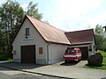
Fire station of the Zettweil volunteer fire brigade

Old fire engine Barkas B 1000 of the Zettweil volunteer fire brigade
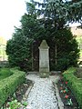
War memorial in the center of Zettweil

War memorial in Zettweil in the center of the village

Interior of the church ruin in Zettweil
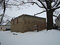
Church ruins in Zettweil

Church ruins of Zettweil

Half-timbered house in Zettweiler Dorfstrasse 19

Hailstones from August 6, 2013

Memorial stone for the cavalry battle near the Kliebe in the run-up to the Battle of Nations


literature
- Helmut Koehler u. a .: Kaynaer Schnauderbote 725 years of Zettweil. Nöbdenitz 2011.
- City of Zeitz: Schnaudertal News , February 9, 2013. Nöbdenitz 2013.
- City of Zeitz: Schnaudertal News , July 9, 2016. Nöbdenitz 2016.
Web links
Individual evidence
- ↑ Ernst Eichler : Slavic place names between Saale and Neisse. Volume IV, Bautzen 2009, p. 114
- ^ The places of the manor Kayna in the Zeits office, book "Geography for all estates", p. 699
- ^ Karlheinz Blaschke , Uwe Ulrich Jäschke : Kursächsischer Ämteratlas , Leipzig 2009, ISBN 978-3-937386-14-0 , p. 86 f.
- ^ The Zeitz district in the municipal directory 1900
- ↑ Zettweil village renewal
- ^ Severe weather in Saxony, Thuringia, Saxony-Anhalt
- ↑ Severe weather in the Burgenland district
- ↑ [1]
- ↑ a b c City of Zeitz: Schnaudertal news . No. 06/2016 . Nöbdenitz June 11, 2016, p. 4 .
- ^ City of Zeitz: Schnaudertal news . No. 03/2017 . Nöbdenitz March 11, 2017, p. 4 .
- ^ City of Zeitz: Schnaudertal news . No. 03/2018 . Nöbdenitz March 10, 2017, p. 2 .
- ^ Website of the Starkenberger Quarzsandwerke

Geußnitz: Geußnitz | Wildenborn
Kayna: Kayna | Lindenberg | Grinding | Roda | Zettweil
Luckenau: Luckenau | Streckau (devastated) | Weidau
Nonnewitz: Nonnewitz | Unterschwöditz
Pirkau: Dobris (devastated) | Neu-Pirkau | Pirkau (devastated) | Schwerzau (devastated)
Theißen: Theißen
Würchwitz: Bockwitz | Lobas | Loitsch | Sabissa (devastated) | Stockhausen | Suxdorf | Würchwitz with Podebuls
Zangenberg: Zangenberg
Zeitz: Aue | Aylsdorf | Hainichen | Posa Monastery | Rasberg | Time