La Puebla de Valverde: Difference between revisions
Content deleted Content added
Hmainsbot1 (talk | contribs) m AWB general fixes and delink dates per WP:DATELINK, WP:YEARLINK and MOS:UNLINKYEARS using AWB (8097) |
Rescuing 1 sources and tagging 0 as dead.) #IABot (v2.0.9.4 |
||
| (18 intermediate revisions by 12 users not shown) | |||
| Line 4: | Line 4: | ||
| official_name = <!-- if different from name --> |
| official_name = <!-- if different from name --> |
||
| native_name = <!-- if different from name --> |
| native_name = <!-- if different from name --> |
||
| image_skyline = |
| image_skyline = Muralla lejana.JPG |
||
| image_alt = |
| image_alt = |
||
| image_caption = |
| image_caption = |
||
| Line 24: | Line 24: | ||
| subdivision_type3 = [[Comarcas of Aragon|Comarca]] |
| subdivision_type3 = [[Comarcas of Aragon|Comarca]] |
||
| subdivision_name3 = [[Gúdar-Javalambre]] |
| subdivision_name3 = [[Gúdar-Javalambre]] |
||
| subdivision_type4 = [[Judicial district]] |
| subdivision_type4 = [[Judicial districts of Spain|Judicial district]] |
||
| subdivision_name4 = Teruel |
| subdivision_name4 = Teruel |
||
| seat_type = <!-- [[Capital (political)|Capital]] --> |
| seat_type = <!-- [[Capital (political)|Capital]] --> |
||
| seat = |
| seat = |
||
| coordinates = {{coord|40|13|N|0|55|W|type:city|display=inline,title}} |
|||
| latd = 40|latm = 13|lats = |latNS = N |
|||
| longd= 0|longm = 55|longs= |longEW= W |
|||
| coordinates_type = type:city |
|||
| coordinates_display = inline,title |
|||
| coordinates_footnotes = |
| coordinates_footnotes = |
||
| elevation_m = 1183 |
| elevation_m = 1183 |
||
| Line 40: | Line 37: | ||
| established_title = <!-- Founded --> |
| established_title = <!-- Founded --> |
||
| established_date = |
| established_date = |
||
| population_as_of = {{Spain metadata Wikidata|population_as_of}} |
|||
| population_footnotes = <!-- for references: use <ref> tags --> |
|||
| population_footnotes = {{Spain metadata Wikidata|population_footnotes}} |
|||
| population_total = 540 |
|||
| population_total = {{Spain metadata Wikidata|population_total}} |
|||
| population_as_of = 2008 |
|||
| population_demonym = Pueblano, -a |
| population_demonym = Pueblano, -a |
||
| population_note = |
| population_note = |
||
| Line 63: | Line 60: | ||
}} |
}} |
||
'''La Puebla de Valverde''' is a municipality located in the [[Teruel (province)|province of Teruel]], [[Aragon]], |
'''La Puebla de Valverde''' is a municipality located in the [[Teruel (province)|province of Teruel]], [[Aragon]], Spain. According to the 2004 [[census]] ([[Instituto Nacional de Estadística (Spain)|INE]]), the municipality had a population of 508 inhabitants. |
||
This town is located at the feet of the [[Sierra de Camarena]], [[Sistema Ibérico]]. |
This town is located at the feet of the [[Sierra de Camarena]], [[Sistema Ibérico]]. |
||
| ⚫ | |||
| ⚫ | |||
==See also== |
|||
| ⚫ | |||
*[[Escandón Pass]] |
|||
==References== |
|||
| ⚫ | |||
{{reflist}} |
|||
[[Category:Populated places in the Province of Teruel]] |
|||
| ⚫ | |||
| ⚫ | *[http://www.dpteruel.es/WebDPT/Municipios.nsf/0/F0F8F9A88D55C550C125701C003A60F4?Opendocument&Incrustado=1 La Puebla de Valverde on Diputación de Teruel] {{Webarchive|url=https://web.archive.org/web/20120220011853/http://www.dpteruel.es/WebDPT/Municipios.nsf/0/F0F8F9A88D55C550C125701C003A60F4?Opendocument&Incrustado=1 |date=2012-02-20 }} |
||
{{ |
{{Gúdar-Javalambre}} |
||
| ⚫ | |||
{{authority control}} |
|||
[[an:La Puebla de Valverde]] |
|||
[[ca:La Pobla de Valverde]] |
|||
| ⚫ | |||
[[es:La Puebla de Valverde]] |
|||
{{Teruel-geo-stub}} |
|||
[[eu:La Puebla de Valverde]] |
|||
[[fr:La Puebla de Valverde]] |
|||
[[it:La Puebla de Valverde]] |
|||
[[kk:Ла-Пуэбла-де-Вальверде]] |
|||
[[nl:La Puebla de Valverde]] |
|||
[[uz:La Puebla de Valverde]] |
|||
[[pt:La Puebla de Valverde]] |
|||
[[ru:Ла-Пуэбла-де-Вальверде]] |
|||
[[uk:Ла-Пуебла-де-Вальверде]] |
|||
[[vi:La Puebla de Valverde]] |
|||
[[war:La Puebla de Valverde]] |
|||
Latest revision as of 03:37, 31 May 2023
La Puebla de Valverde | |
|---|---|
 | |
 | |
| Coordinates: 40°13′N 0°55′W / 40.217°N 0.917°W | |
| Country | |
| Autonomous community | |
| Province | Teruel |
| Comarca | Gúdar-Javalambre |
| Judicial district | Teruel |
| Government | |
| • Alcaldesa | María Luisa Fuertes Alegría (2007) |
| Area | |
| • Total | 282.78 km2 (109.18 sq mi) |
| Elevation | 1,183 m (3,881 ft) |
| Population (2018)[1] | |
| • Total | 453 |
| • Density | 1.6/km2 (4.1/sq mi) |
| Demonym(s) | Pueblano, -a |
| Time zone | UTC+1 (CET) |
| • Summer (DST) | UTC+2 (CEST) |
| Postal code | 44450 |
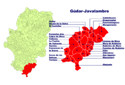
La Puebla de Valverde is a municipality located in the province of Teruel, Aragon, Spain. According to the 2004 census (INE), the municipality had a population of 508 inhabitants.
This town is located at the feet of the Sierra de Camarena, Sistema Ibérico.
See also[edit]
References[edit]
- ^ Municipal Register of Spain 2018. National Statistics Institute.
External links[edit]
- La Puebla de Valverde on Diputación de Teruel Archived 2012-02-20 at the Wayback Machine

