Agrinio
|
Agrinio municipality Δήμος Αγρινίου (Αγρίνιο) |
||
|---|---|---|
|
|
||
| Basic data | ||
| State : |
|
|
| Region : | West Greece | |
| Regional District : | Aetolia-Acarnania | |
| Geographic coordinates : | 38 ° 38 ′ N , 21 ° 25 ′ E | |
| Area : | 1,246.65 km² | |
| Residents : | 94,181 (2011) | |
| Population density : | 75.5 inhabitants / km² | |
| Post Code: | 30100 | |
| Prefix: | (+30) 26410 | |
| Community logo: | ||
| Seat: | Agrinio | |
| LAU-1 code no .: | 3803 | |
| Districts : | 10 parishes | |
| Local self-government : |
6 city districts 54 local communities |
|
| Website: | www.agrinio.gr | |
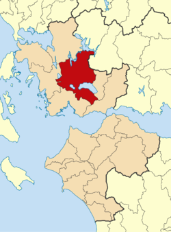
| Location in the region of Western Greece | ||
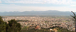
Agrinio ( pronunciation : [ aˈɣrinjɔ ], Greek Αγρίνιο ( n. Sg. ), In ancient times Agrinion , Latin Agrinium ) is the second largest city in the Greek administrative region of western Greece after Patras .
geography
Agrinio lies in the Aetolian plain and is bordered to the north by Lake Kremasta and to the east by its outflow, the Acheloos , which is dammed up to the Stratos reservoir in the northwest . In the municipality of Stratos, the municipality extends to the west over the Achellos and reaches as far as the Ozeros Lake . The neighboring communities are Amfilochia in the north and Xiromero in the west. In the northeast, the Panetoliko mountain range forms the border with central Greece. The area of the municipality extends far to the east, it covers over half of the Trichonida Lake and borders here on the municipalities of Thermo and Nafpaktia . In the south, beyond Lake Lysimachia, the municipality of Mesolongi borders on Agrinio, in which the Acheloos branches off to form its delta - the municipality of Agrinios has no access to the sea.
The urban area of Arginio is flat to hilly. Only the northern and eastern districts nestle against the slopes of Panetoliko. The entire area around Agrinio is used intensively for agriculture; the system of reservoirs of the Acheloos and its tributaries is also used to irrigate the agricultural areas.
history
According to mythology, Agrinion was founded by King Agrio from the Aetolian tribe. 314 BC It was destroyed by the Macedonian king Kassander . Apparently during the Ottoman rule over Greece the city was re-established about 3 km southwest of the ancient place; she was called Vrachori ( Greek Βραχώρι or Imbrahoar) at that time . During this period, many Ottomans settled in the city. At the beginning of the 18th century, today's Agrinio became the capital of a sanjak . In 1821, residents of Agrinio took part in the fighting during the Greek War of Independence and were able to bring the city under Greek control for the first time on June 11, 1821. After being reconquered by the Ottomans in the meantime, Agrinio was finally added to Greece in 1832, with the ancient name Agrinio being used again.
At the end of the 19th and beginning of the 20th century, Agrinio experienced an economic boom through the cultivation of tobacco. Well-known Greek families with a connection to tobacco cultivation and production such as Papastratos, Papapetros and Paganopoulos had warehouses and factories for the production of smoking tobacco in and around Agrinio. In 1922, after the Greek defeat in the Greco-Turkish war, refugees from Asia Minor came to Agrinio as part of the so-called “ population exchange ” and settled in the area of Agios Konstatinos. Residents from Epirus and Evrytania also moved to Agrinio.
Community structure
→ Administrative division of the municipality of Agrinio
Agrinio received the status of a rural community (kinotita) in 1912 and was raised to the status of an urban community (dimos) in 1923 . The community grew continuously through the incorporation of surrounding villages. The last expansion resulted from the Kallikratis program in 2010, when nine surrounding parishes were added to the parish. Since then Agrinio has been divided into ten municipal districts (corresponding to the municipalities until 2010), these in turn into 50 localities (corresponding to the municipalities before the municipal reform in 1997). The localities are represented by local councils, seven of them have more than 2000 inhabitants and are classified as dimotiki enotita , the rest as topiki kinotita. The result of the 2001 census shows 176 inhabited settlements and places to live in the municipality in addition to the core town of Agrinio itself.
traffic
Road traffic
Agrinio is an important traffic junction, especially in road traffic. The national road 5 crosses Agrinio coming from the north ( Igoumenitsa , Prevesa , Ioannina , Arta ) to the south ( Messolongi , Patras , Nafplio ). The national road 5 is also the European route 55 and the European route 951 . The national road 38 leads from Agrinio to the east or northeast along the west and north flanks of the Panetoliko massif to Lamia via Karpenissi and Makrakomi . This national road is also the European route 952 . Over the next few years, the construction of Autobahn 5 (Ionia Odos) Agrinio will provide a bypass and a connection to the growing Greek motorway network.
Airfield
Agrinio has a military airfield ( IATA : AGQ , ICAO : LGAG ) in the southwest of the city , which was also used for civilian purposes. The asphalt runway with an alignment of 09/27 is 3,010 m long and 30 m wide. The military airfield is at an altitude of 47 m (154 ft) above sea level . The Greek Air Force relocated aircraft and personnel to Aktio Airport in the mid-2010s .
![]()
The old closed airport ( ) is about 2.5 kilometers from the Agrinio military airfield. The asphalt runway with an orientation of 14/32 is 1,260 m long and 30 m wide.
![]()
rail
From 1890 to 1970 Agrinio was the northern terminus of the narrow-gauge Greek Northwest Railway . It led over 61 km to the port of Kryoneri on the Gulf of Corinth from where there was a ferry to Patras . In 1970 the line was closed . From 1996 the line was restored in whole or in sections, but work that was discontinued in 2004 without the resumption of operations. At times there were plans to upgrade the line to standard gauge as part of the Trans-European Networks and to extend it to Ioannina .
Attractions
- the preserved tobacco warehouses of the Papastratos company
- the Papastrateio public park
- the archaeological museum
- the ethnological museum
- the Papastrateio public library
- the church of Agia Triada des Maurika from the 8th to 9th centuries
- the ancient Stratos
- the Kremasta reservoir (via national road 38)
- the Stratos reservoir
- the Kastrakio reservoir (via national road 38)
Personalities
- Efstratios Apostolakis (* 1964), football player
- Panagiotis Danglis, general and politician
- Konstantinos Domadis, writer
- Christos Garoufalis, painter
- Aristidis Moschos, musician
- Evangelos Papastratos, tobacco manufacturer
- Georgios Zaravinas, handball player
- Georgios Kalamidas (* 1944), President of the Areopagus
literature
- Eugene Vanderpool : Agrinion Greece . In: Richard Stillwell et al. a. (Ed.): The Princeton Encyclopedia of Classical Sites. Princeton University Press, Princeton NJ 1976, ISBN 0-691-03542-3 .
- Henning Wall: Railway Atlas Greece . Schweers + Wall, Cologne 2018.
Web links
Individual evidence
- ↑ Results of the 2011 census at the National Statistical Service of Greece (ΕΛ.ΣΤΑΤ) ( Memento from June 27, 2015 in the Internet Archive ) (Excel document, 2.6 MB)
- ^ [X] Agrinion. In: airportguide.com. Retrieved February 1, 2020 .
- ↑ Τέλος και η Αεροπορία! In: agrinionews.gr. June 30, 2014, accessed February 1, 2020 (Greek).
- ^ So: Wall: Eisenbahnatlas , S. XII.
- ^ So: Wall: Eisenbahnatlas , p. 10.
- ^ Wall: Railway Atlas , p. XII.


