
Ahrensmoor
|
Ahrensmoor
municipality Ahlerstedt
|
||
|---|---|---|
 |
||
| Height : | 41 m | |
| Area : | 3.32 km² | |
| Residents : | 452 (2003) | |
| Population density : | 136 inhabitants / km² | |
| Incorporation : | July 1, 1972 | |
| Postal code : | 21702 | |
| Area code : | 04166 | |
Location of Ahrensmoor in Lower Saxony |
||
 Memorial stone on the occasion of the 200th anniversary in 2003
|
||


Ahrensmoor ( Low German Ohrensmoor ) is a village in the municipality of Ahlerstedt , Samtgemeinde Harsefeld in the Stade district in Lower Saxony ( Germany ).
geography
Ahrensmoor lies south of the nature reserves “ Braken and Harselah ” and “ Kahles and Wildes Moor ”. The floodplain rises on the Ahrensmoor high moor.
The village of Ahrensmoor is divided into the districts of Ahrensmoor-Ost , Ahrensmoor-West and Ahrensmoor-Nord .
Neighboring places
| Hollenbeck | Harsefeld | Revenahe-Kammerbusch |
| Klethen , Ahlerstedt |
.svg)
|
|
| Ahrenswohlde , Klein Wangersen | Wiegersen , Wohnste |
history
Local history
Ahrensmoor was founded as a moor colony in 1803 as part of the moor colonization . The reason for the foundation were disputes between Klethen and Ahrenswohlde , who was responsible for maintaining the Aue (Lühe) crossing in the course of the road between Hamburg and Bremen (now the intersection of L 127 Weststraße with Ahlerstedter Weg and Schuldamm). This led here on a dam on the edge of a moor area and was repeatedly in poor condition or even impassable. After the experiences with the moor colonization in the Great Moor near Bremervörde under Findorff , it was decided to found a moor colony. This should then take over the maintenance of the path. The first measurements were carried out in 1795, the foundation took place in 1803, but it took until 1814 for the foundation to be completed. 11 settler sites and a school site were created on the west side and 10 settler sites on the east side; this is how Ahrensmoor East and West were created, separated by Bültmoor and Scholermoor. The only connection back then was the Schuldamm.
A curiosity about this foundation was that it was decided in London's St James's Palace . The Elector of Hanover , Georg III. , was also King of England and resided exclusively in London.
The name Ahrensmoor is derived from Ahrenswohlde , in whose area Ahrensmoor was founded. Ahrenswohlde was located between forests ( -wohlde ), but the new foundation was between moors, hence Ahrensmoor .
The first school was built in 1817, the second in 1852. In 1912, Weststrasse was expanded with paving stones .
After the First World War a vigilante group was founded in Ahrensmoor ; but it only had one mission and was disbanded in 1920.
Ahrensmoor received its first power connection in 1919, and from 1923 from the overland plant. In 1961 the first water pipe was laid.
The voluntary fire brigade has existed in Ahrensmoor since 1935, and in 1990 they moved into a new fire station . School operations were finally stopped in 1991.
Incorporations
In 1955, Klein Ahlerstedt and a few other houses on the outskirts towards Harselah ( Depenrehmen ) and the Harselah farm were incorporated as Ahrensmoor-Nord .
Regional affiliation
Before 1885 Ahrensmoor belonged to the Börde Ahlerstedt in the district of Harsefeld , after 1885 to the district of Stade and since 1932 to the current district of Stade .
From 1967 to 1971 Ahrensmoor was a member municipality of the Ahlerstedt joint municipality .
As part of the community reform, Ahrensmoor was incorporated into the community of Ahlerstedt on July 1, 1972 .
religion
Ahrensmoor is evangelical-Lutheran and belongs to the parish of the church Ahlerstedt .
Population development
| year | Residents |
|---|---|
| 1824 | 21 fire places |
| 1848 | 121 people, 23 houses |
| 1910 | 138 |
| 1939 | 149 |
politics
coat of arms
Ahrensmoor does not have a real coat of arms, but a logo that is used by the village as a coat of arms and, for example, decorates the local festival hall.
Culture
societies
- Ahrensmoor local history association
- Volunteer firefighter
- DG Ahrensmoor (recreational football and youth club)
- Moorpuggen (amateur play group, founded 1962)
- Minstrel march (founded 1965)
- Senior meeting "AST" (founded in 1992)
- Yoga group
- "Get involved - stay fit", gymnastics group Ahrensmoor
- Ahrensmoor hiking group
Monuments
A memorial for those who died in the war has stood in the cemetery since 1921.
Cultural spaces
- Oven: Historic oven, dismantled in the course of the expansion of the L 127 on Nordstrasse (Hof Polle) and rebuilt behind the multi-purpose hall in the school's former orchard
- Sheepfold: An expanded sheepfold from 1812 that was in use until around 1960. It was renovated and inaugurated in 1986 as a new celebration room
- Multipurpose hall with hall from 1968
- Sauna in the building of the multi-purpose hall
Economy and Infrastructure
economy
There are several artisanal businesses on site. A bricklaying company is worth mentioning .
traffic
Ahrensmoor-West and -Nord are on the state road 127, which leads in the northeast via Revenahe-Kammerbusch to Apensen and Buxtehude and in the southwest via Ahrenswohlde to Wangersen to the L 124. Ahrensmoor-Ost is on Kreisstraße 59, which is a side road to the L 127. The K 59 continues as K 121 into the Rotenburg (Wümme) district to Wohnste . From Ahrensmoor the K 75 to Ahlerstedt in the west and the K 79 to Griemshorst from the L 127 in the northwest .
gallery
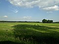
Geest landscape between Ahrensmoor north and west

Schuldamm, formerly the only connection between Ahrensmoor-West and -Est
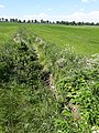
Aue in Ahrensmoor.


Web links
literature
- Frauke Eckhoff, Anette Lühmann, Helmut Meyer u. a .: Village history Ahrensmoor 1803 - 2003 . Hamburg 2003.
Individual evidence
- ^ Federal Statistical Office (ed.): Historical municipality directory for the Federal Republic of Germany. Name, border and key number changes in municipalities, counties and administrative districts from May 27, 1970 to December 31, 1982 . W. Kohlhammer, Stuttgart / Mainz 1983, ISBN 3-17-003263-1 , p. 246 .
- ↑ CHCF Jansen: Statistical Handbook of the Kingdom of Hanover . In Commission of the Helwings̓chen Hofbuchhandlung, 1824, p. 8 ( Textarchiv - Internet Archive ).
- ↑ FW Harseim: Statistical Manual for the Kingdom of Hanover . Schlueter, 1848, p. 134 ( Textarchiv - Internet Archive ).
- ↑ Gemeindeververzeichnis.de. Retrieved October 26, 2018 .

Ahlerstedt (core town) | Ahrensmoor | Ahrenswohlde | Bokel | Kakerbeck with Kakerbeck-Doosthof and Bockholt | Oersdorf with Kohlenhausen | Ottendorf with Klethen | Wangersen with Klein Wangersen and Hohenhausen