Alteburg (Soonwald)
| Old castle | ||
|---|---|---|
|
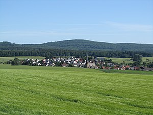
Alteburg from the south, in the foreground Seesbach |
||
| height | 620.5 m above sea level NHN | |
| location | at horse field ; District of Bad Kreuznach , Rhineland-Palatinate ( Germany ) | |
| Mountains | Soonwald ( Hunsrück ) | |
| Coordinates | 49 ° 52 '48 " N , 7 ° 32' 48" E | |
|
|
||
| particularities | - Wall system - Alteburgturm ( AT ) |
|
The Alteburg near the former village of Pferdefeld in the Rhineland-Palatinate district of Bad Kreuznach is 620.5 m above sea level. NHN high mountain in the Soonwald , part of the Hunsrück . A rampart and the Alteburgturm observation tower are located on top of it .
geography
location
The Alteburg is located in the southwest of the Soonwald in the Soonwald-Nahe Nature Park . Its mountain peak rises in the area of the former village , then belonging to Bad Sobernheim, horse field , which was abandoned around 1980 because of the neighboring horse field air base ; the air base was closed in 1997, and its site is currently used, among other things, as a test and event center for Adam Opel AG . About 20 m north-west of the summit runs the border to the district of 3.2 km south-west lying village of Schwarzerden . About 6.5 km east of the summit is Winterbach , 6.3 km east -south- east Ippenschied , 3.8 km south Seesbach , 3.7 km south-south-west Weitersborn , 3.8 km west-south-west Henau , 5.2 km west-north-west Gemünden and 4.7 km km (as the crow flies ) north-west of Mengigart . To the north the terrain slopes down to the Lametbach , to the southeast to the Kieselbach and to the southwest, past the Schwarzerdener Höhe ( 550 m ), to the Kellenbach , the lower reaches of the Simmerbach .
Natural allocation
The Alteburg heard in the natural environment feature unit group Hunsrück (no. 24) in the main unit Soonwaldsteig (240) and in the sub unit Large Soon (240.1) for the same natural space Large Soon (240.11), wherein the landscape towards the south-west in the natural environment Simmersbach breakdown ( 240.12) falls.
Protected areas
Parts of the Soonwald landscape protection area ( CDDA no. 324698; designated 1980; 272 km² in size) and the Soonwald fauna-flora-habitat area (FFH no. 6011-301; 57.32 km²) lie on the wooded Alteburg . To the northeast of the mountain in the Lametbachtal lies the Im Eschen nature reserve (CDDA No. 163860; 1984; 43 ha ) and to the southeast the landscape falls into the Bruchwiesen nature reserve (CDDA No. 162588; 1992; 6 ha) and Im Graefenbrühl (CDDA- No. 163867; 1991; 5 ha).
Rampart
Immediately on the tower is an almost square rampart of a previously unknown time position and function. The wall has an area of 70 mx 70 meters (4,900 m²) with a nearly 1 m high collapsed wall that is up to 6 m wide at the base. It is believed that the wall was a Celtic refuge from the La Tène period (500–20 BC).
Alteburgturm
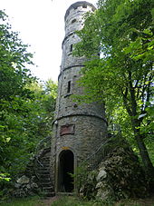
The 20 m high Alteburgturm has stood on the Alteburg summit since 1893 and was built as a lookout tower by the Soonwald Club; today it is owned by the Hunsrück Association. It is a listed building and is freely accessible. Two stairs on the outside of the tower lead to the high entrance opposite, followed by a spiral staircase with 67 steps to the covered viewing platform .
From the Alteburgturm you have a view of the Hunsrück heights with Erbeskopf , Idarwald , Hahn Airport and Fleckertshöhe as well as parts of Rheinhessen , the Naheland ( Gauchswald , Schanzenkopf , Lemberg ) and the North Palatinate Bergland ( Donnersberg , Bornberg ). If the conditions are good, parts of the Eifel can also be seen ( Kondelwald , Hocheifel ).
Traffic and walking
Country road 229 runs over the saddle between Alteburg and the southwestern Schwarzerdener Höhe between the former horse field in the former village of Pferdefeld in the southeast and Gemünden in the northwest. For example , starting at the car park near the highest point ( 528.1 m ) on the road you can hike on forest paths (such as the Rennweg that runs there ) and paths to the mountain summit and to the nearby Ellerspring ( 657.5 m ) in the northeast. The European long-distance hiking trail E3 also connects both hiking destinations .
Individual evidence
- ↑ a b c Map service of the landscape information system of the Rhineland-Palatinate nature conservation administration (LANIS map) ( notes )
- ↑ Map services of the Federal Agency for Nature Conservation ( information )
- ^ General Directorate for Cultural Heritage Rhineland-Palatinate (ed.): Informational directory of cultural monuments - Bad Kreuznach district. Mainz 2020, p. 41 (PDF; 8.1 MB).
Web links
- Hans H. Stassen: Alteburg (620 m) with Celtic refuge castle. In: maasberg.ch. Archived from the original on June 30, 216 (explanations as part of a hiking recommendation).
- Monika Kirschner, Hans-Werner Ziemer: Altenburg Tower in the Soonwald. In: soonwald.de. May 18, 2010 .
- Gustav Schellack: Lookout towers in the Hunsrück. In: hunsrueck-zeitung.com. Archived from the original on July 5, 2019 .
- Jörg Nitz: Visibility in the Hunsrück. In: panorama-photo.net. July 22, 2012 (inscribed panoramic view from the Alteburgturm; viewer for Internet Explorer ).


