Autovía A-48
| Autovía A-48 in Spain | |||||||||||||||||||||||||||||||||||||

|
|||||||||||||||||||||||||||||||||||||
| |
|||||||||||||||||||||||||||||||||||||
| map | |||||||||||||||||||||||||||||||||||||
| Basic data | |||||||||||||||||||||||||||||||||||||
| Operator: | |||||||||||||||||||||||||||||||||||||
| Overall length: | 146 km | ||||||||||||||||||||||||||||||||||||
| of which in operation: | 36 km | ||||||||||||||||||||||||||||||||||||
| of which in planning: | 110 km | ||||||||||||||||||||||||||||||||||||
|
Course of the road
|
|||||||||||||||||||||||||||||||||||||
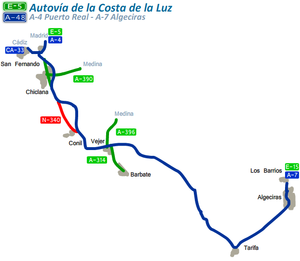
The Autovia A-48 or Autovía Costa de la Luz is a motorway in Spain . The motorway starts in Cádiz and ends in Algeciras . The motorway is completed as far as Vejer de la Frontera, the rest of the route is being planned.
Route
Sections
| position | Abbreviation of the section | section | km | opening |
|---|---|---|---|---|
| 1 | A-48 | Tres Caminos - Chiclana de la Frontera Norte | 3 | 1991 |
| 2 | A-48 | Variant of Chiclana de la Frontera | 7th | 2002 |
| 3 | A-48 | Chiclana de la Frontera south - Conil de la Frontera south | 18.7 | 2006 |
| 4th | A-48 | Conil de la Frontera south-Vejer de la Frontera | 6th | 2007 |
| 5 | Vejer de la Frontera- La Janda | in planning | ||
| 6th | La Janda- Facinas | in planning | ||
| 7th | Facinas- Tarifa | in planning | ||
| 8th | Tarifa- Algeciras | in planning | ||
| 9 | New western bypass to Algeciras | 12 | in planning |
Routing
| position | maximum speed (km / h) | Roadways | Direction (France) | Direction (madrid) | Roadways |
|---|---|---|---|---|---|
| 1 | 80 |
Chiclana de la Frontera : 7 Algeciras : 105 Málaga : 240 |
San Fernando : 5 Cadiz : 13 |
CA-33 | |
| 2 | 80 | 1 |
Puerto Real : 10 El Puerto de Santa María : 18 Seville : 120 |
E-5 A-4 |
|
| 3 | 80 | 2 | Cambio de sentido | Cambio de sentido | |
| 4th | 80 | 3 | Chiclana de la Frontera | Chiclana de la Frontera | N-340 |
| 5 | 120 | 7th | Chiclana de la Frontera Medina-Sidonia |
Chiclana de la Frontera Medina-Sidonia |
A-390 |
| 6th | 120 | 10 | Chiclana de la Frontera | Chiclana de la Frontera | N-340 |
| 7th | 120 | 15th |
Barrio Nuevo La Barca de la Florida |
N-340 | |
| 8th | 120 | 19th | Los Naveros | CA-3206 | |
| 9 | 120 | 26th | Conil de la Frontera | Conil de la Frontera | N-340 |
| 10 | 120 | 30th | La Muela | La Muela | CA-4200 |
| 11 | 120 | 36 | Vejer de la Frontera | Vejer de la Frontera | A-2229 |
| 12 | 100 |
Tarifa : 48 Algeciras : 69 Málaga : 204 |
Cadiz : 49 | N-340 |
Bigger cities on the highway

The A-48 near San Fernando

