
Beiersdorf (Fraureuth)
|
Beiersdorf
Community Fraureuth
Coordinates: 50 ° 40 ′ 52 ″ N , 12 ° 20 ′ 48 ″ E
|
||
|---|---|---|
| Height : | 328 m | |
| Residents : | 750 | |
| Incorporation : | January 1, 1994 | |
| Incorporated into: | Ruppertsgrün | |
| Postal code : | 08427 | |
| Area code : | 037600 | |
Location of Beiersdorf in Saxony |
||

Beiersdorf is a place in the large community of Fraureuth in the district of Zwickau , Free State of Saxony on the border with the Vogtland district and has almost 750 inhabitants.
geography
location
Beiersdorf is located in the southwestern municipality of Fraureuth on the border with the Saxon Vogtland district and the Thuringian district of Greiz . The Beiersdorfer Bach, which lies in the catchment area of the Pleiße, flows through the village . The Lohbach forms the state border between Thuringia and Saxony. Beiersdorf lies at the transition between the natural areas of the Vogtland ( Middle Vogtland Kuppenland ), Thuringian Slate Mountains ( East Thuringian-Vogtland plateaus ) and the Ore Mountains Basin (Upper Pleißeland). The Leipzig – Hof railway runs east of Beiersdorf, but the place does not stop there.
Neighboring places
| Fraureuth | Ruppertsgrün | |
| God green |
.svg)
|
Gospers green with Roman green |
| Reuth , Schönbach | Neumark | Sub-brand |
history
13th to 18th centuries
The name Beiersdorf was first mentioned in an Elsterberg document on April 25, 1225. In this it was determined that a previous dispute between the Bailiffs von Weida and the Lords von Lobdeburg over the patronage rights of the churches of Greiz and Elsterberg must be ended. The pastor of Beiersdorf signed the document with Henric de Beiersdorph to seal it .
Initially, the area, an unmistakable forest area, belonged to the bailiffs of Weida and later passed to the rule of Schönfels (see Schönfels Castle ), which came under Wettin rule in 1398 and became part of the Electoral Saxon office of Zwickau in the 16th century . The governors of Weida were looking for farmers to make the land arable. The place was probably created as a forest hoof village by Bavarian settlers , but also by farmers from Hesse and Thuringia . Many peasants lived in serfdom to the rule of Schönfels and had to do their labor in the period of feudalism . There is evidence that the von Schönfels family owned the Beiersdorf manor as early as 1398 . In the year 1606, a Vorwerk is mentioned in the place that existed until the 20th century. Until the middle of the 19th century, the manor over Beiersdorf was partly owned by the manors Alt-Schönfels , Neumark , Neuschönfels and Ruppertsgrün , and at times also Reuth .
The place name Beiersdorf was spelled with ey until 1533 , later with ai and only since 1890 has today's spelling been in use. In 1416, Hans von Schönfels is said to have built the Beiersdorf church with his son. From then on, the parish was under the church patronage of the von Schönfels family, who introduced the Reformation in Beiersdorf in 1529 . In 1570 they founded their own parish. The Thirty Years' War in particular was the most difficult time for the residents. The first farmer chronicler Caspar Forberger , who comes from Beiersdorf and began his history of local research in 1616 , also reports on this . In August 1632 the Swedes , with whom Saxony was allied at the time, advanced . Nevertheless, Beiersdorf was looted. In 1633 soldiers set fire to the village and brought in the plague . In the Thirty Years' War, Germany lost 2/3 of its population to the plague and so there was a high death rate in Beiersdorf as well. The consequences of the war weighed heavily on the population for a long time.
19th century to the present
Until 1856, Beiersdorf belonged to the Electoral Saxon or Royal Saxon Office of Zwickau in the Erzgebirge district . In 1856 the place was assigned to the Werdau court office and in 1875 it was incorporated into the Zwickau administration . After 1848 began besides the agriculture and the craft in place to develop such. B. home weaving . Furthermore, the milling industry settled in the place. Even today there is a mill in the village, which is already in the 5th generation of family ownership. In 1875 the old church was partially torn down and replaced by a new building. A new organ was installed by the Werzeit organ builder Johann Bärmig . In 1887/88, industrialization began in Beiersdorf through the textile industry, when the first larger factory, a dye works , was built. Furthermore, a carpentry and a forge were built . In later times, companies in the automotive industry and metal construction also developed .
In 1920 Beiersdorf was assigned to the Werdau administration . Due to the dissolution of the administrative district in 1933, the place came back to the Zwickau district administration, which from 1939 was called the Zwickau district. The First World War and also the Second World War brought victims to the place. On January 27, 1945, the bodies of 5 concentration camp inmates were found on the Beiersdorf corridor . These come from the death marches of the Auschwitz concentration camp (including the satellite camp), which were "cleared" shortly before the liberation . On January 28, 1945, the dead were buried in the dark and without attention in the Beiersdorf cemetery. The grave site was leveled after the fall of the Wall .
In April 1945 the US Army liberated Beiersdorf. After the Potsdam Conference , however, it was handed over to the Soviet occupation zone . The US Army then withdrew its forces from West Saxony to Bavaria . In September 1945 the land reform began in Germany and since 1949 the place belonged to the GDR . As a result of the second district reform in the GDR , the municipality of Beiersdorf came to the Werdau district in the Chemnitz district in 1952 (renamed the Karl-Marx-Stadt district in 1953 ), to which the town belonged until the reunification of Germany . Subsequently, Beiersdorf belonged to the Saxon district of Werdau , which merged in 1994 in the district of Zwickauer Land and in 2008 in the district of Zwickau. On January 1, 1994, Beiersdorf was incorporated into the municipality of Ruppertsgrün next to Gospersgrün (with Römersgrün ) . On January 1, 1998, the four localities Ruppertsgrün, Fraureuth, Gospersgrün and Beiersdorf formed a unified municipality and merged to form the large municipality of Fraureuth.
Beiersdorf lies on the border with the Vogtland district and is still a small, traditional village today. Many farms and houses in the village are under monument protection . This is an attempt to preserve the original character of the area.

View of Beiersdorf (Saxony)

Church tower of the Beiersdorf church
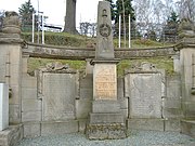
War memorial in memory of the fallen soldiers of the place

Beiersdorf village church


Culture and sights
- Village church from 1516 (renovation and new construction 1875)
- Half-timbered four-sided farmstead, Dorfstr. 50
literature
- The district of Werdau. Interesting facts from the past and present . 1st edition. Geiger, Horb am Neckar 1994. ISBN 3-89264-886-7
Web links
- Beiersdorf in the Digital Historical Directory of Saxony
- Beiersdorf district on the Fraureuth homepage
Individual evidence
- ↑ The Vorwerk Beiersdorf at www.sachsens-schlösser.de
- ↑ Schönfels Castle at www.sachsens-schlösser.de
- ↑ The manor Neumark on www.sachsens-schlösser.de
- ^ The Neuschönfels Castle at www.sachsens-schlösser.de
- ↑ The Ruppertsgrün manor at www.sachsens-schlösser.de
- ^ The Reuth manor at www.sachsens-schlösser.de
- ^ Karlheinz Blaschke , Uwe Ulrich Jäschke : Kursächsischer Ämteratlas. Leipzig 2009, ISBN 978-3-937386-14-0 ; P. 64 f.
- ↑ The Zwickau administrative authority in the municipal register 1900
- ↑ Jens Müller: One name is now known. In: Free Press. June 19, 2013, archived from the original on July 5, 2013 ; Retrieved July 5, 2013 .
- ↑ Municipalities 1994 and their changes since January 1, 1948 in the new federal states , Metzler-Poeschel publishing house, Stuttgart, 1995, ISBN 3-8246-0321-7 , publisher: Federal Statistical Office
- ^ StBA: Changes in the municipalities in Germany, see 1998
