
Hergatz
| coat of arms | Germany map | |
|---|---|---|

|
Coordinates: 47 ° 39 ' N , 9 ° 50' E |
|
| Basic data | ||
| State : | Bavaria | |
| Administrative region : | Swabia | |
| County : | Lindau (Lake Constance) | |
| Height : | 600 m above sea level NHN | |
| Area : | 18.79 km 2 | |
| Residents: | 2422 (Dec. 31, 2019) | |
| Population density : | 129 inhabitants per km 2 | |
| Postal code : | 88145 | |
| Area code : | 08385 | |
| License plate : | LI | |
| Community key : | 09 7 76 131 | |
| LOCODE : | DE HGZ | |
| Community structure: | 21 parts of the community | |
| Address of the municipal administration: |
Salzstrasse 18 88145 Hergatz |
|
| Website : | ||
| Mayor : | Oliver-Kersten Raab | |
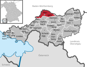
| Location of the municipality of Hergatz in the district of Lindau (Lake Constance) | ||
  |
||


Hergatz ( westallgäuerisch Hörgatz ) is a municipality and a town in the Bavarian-Swabian district of Lindau (Bodensee) . The community emerged in its current form at the end of the 1970s as part of the community reform from the old communities of Wohmbrechts and Maria-Thann.
geography
Parish parts
The municipality has 21 officially named municipal parts (the type of settlement is given in brackets ):
|
|
location
The municipality in the western Allgäu is located at an altitude of 550 to 630 meters above sea level. The municipality borders in the northeast on the Obere Argen , in the northwest on the downstream left tributary Schwarzenbach . Both are border rivers from Bavaria to Baden-Württemberg. On the south side, the municipality ends at the stretch of water from its right upper course tributary Dürrach and further to the west the Leiblach itself. Upper Argen and Leiblach drain into the eastern Lake Constance.
The districts of Grod, Beuren, Möllen, Wohmbrechts and Hergatz are on the federal highway 12 Munich – Lindau, about 20 km from Lindau . In Wohmbrechts, the B 12 is the through-town. The districts of Grod, Staudach and Handwerks are located on the south bank of the Upper Argen or in its left floodplain.
The Tyrolean Salt Road from Bad Reichenhall and Hall in Tirol to Lindau leads through the district of Wohmbrechts, where a former salt barn is located, the predecessor of which is likely to have stood here as early as 1513.
Neighboring communities
| Wangen in the Allgäu | Argenbühl | |
.svg)
|
||
| Hergensweiler | Opfenbach | Heimenkirch |
history
Until the church is planted
The municipality of Hergatz was created on May 1, 1978 from the merger of the municipalities of Wohmbrechts and Maria-Thann. Hergatz, which gives the new community its name, was previously a district of Wohmbrechts.
Hergatz was mentioned for the first time in 1349. At that time, the lords of Ellhofen, the Schlaich von Schreckelberg, the Vogtei Wohmbrechts and Wangen citizens owned and ruled. The latter, together with Wohmbrechts, formed the main team in the area of the imperial city of Wangen . Edelitz, which today belongs to the parish of Hergatz, but formerly belonged to the parish of Wohmbrechts, had five estates in 1574 as St. Gallen fiefs ( after fiefs of Syrgenstein). Four of them remained serviceable until the 19th century.
The road connection from Isny to Lindau (Salzstraße or today's Bundesstraße 12) leads through Wohmbrechts and Hergatz and shaped these places. It was also used by pilgrims, as Wohmbrechts was a much-visited place of pilgrimage until the 18th century. In 1739 the bones of the blessed nun Richildis were buried in the parish church.
The last salt factory was located on the Salt Road in Wohmbrechts, which runs via Kempten, Isny and Wangen to Lake Constance. In 1853 the Buchloe – Lindau line was completed, which also runs through Wohmbrechts and Hergatz. In 1890, the town of Wangen and the Upper Swabian hinterland in Hergatz were connected to this route, making the place an important traffic junction. This gave the dairy products of the cheese factory P. Paul Eberle founded in Hergatz a market.
Wohmbrechts
This district, which is also the administrative center, was first mentioned in a document in 1269. The knights of Wohmbrechts also appeared in the 13th and 14th centuries. Of these, Ulrich von Wohmbrechts was the most energetic and warlike representative and for years fought with the abbot of Weingarten monastery over a forest, which he claimed as a fief . His seal had three griffin claws, of which the current coat of arms of the Hergatz community contains one.
Wilhelm von Wohmbrechts, a descendant of Ulrichs, was known throughout Europe as a warrior as he fought for the King of Denmark against the Swedes and Lithuanians. He also went to war for the Margrave of Brandenburg, the Count of Tyrol and the Duke of Baiern. Wohmbrechts Castle was probably built in its time.
Maria-Thann
Maria-Thann was initially only known under the name Tann (e) ( settlement in the fir forest ). It was only when the Marian pilgrimage began in the 15th century that the place was given the addition of Maria . However, this has only been secured since the 19th century.
The first reliable mention of Maria-Thann is in the Liber taxationis of the Diocese of Constance ( ecclesia in Tanne ). However, Eberhardus de Tanna 1187 and Bertholdo princerna ( cupbearer ) de Tanne 1216 do not refer to Maria-Thann. These were Upper Swabian Reichsministeriale whose names went back to Tanne Castle, northeast of Ravensburg. In 1353 there were 24 houses in the settlement.
At the beginning of the 16th century, Wangen was given high jurisdiction over Maria-Thann and Wohmbrechts. This gave rise to the Thann-Wohmbrechts main team in Wangen, which went with Wangen to the Bavarian Kingdom in 1802. In 1810, Wangen became an administrative center in Württemberg, but Maria-Thann and Wohmbrechts remained Bavarian.
In 1865 the municipality of Thann (Maria) was officially renamed Maria-Thann .
Population development
Hergatz grew by 153 inhabitants or about 7% from 1988 to 2008. Between 1988 and 2018 the municipality grew from 2,168 to 2,427 by 259 inhabitants or by 12%.
The population figures from 1840 onwards relate to today's municipality area (status: 1978).
| Population development | ||||||||||||||
|---|---|---|---|---|---|---|---|---|---|---|---|---|---|---|
| year | 1840 | 1900 | 1939 | 1950 | 1961 | 1970 | 1987 | 1991 | 1995 | 2000 | 2005 | 2010 | 2015 | 2016 |
| Residents | 849 | 1093 | 1262 | 1642 | 1720 | 1882 | 2158 | 2230 | 2302 | 2264 | 2297 | 2309 | 2393 | 2387 |
coat of arms
|
|
Blazon : “In silver a curled red tip, inside a silver heraldic lily; a black griffin catcher at the front, a black sloping bar at the back. " |
Culture and sights


Buildings
Wohmbrechts
The former castle and the church of St. George can be visited. The former salt barn is on the B 12 . Among other things, a pizzeria is housed in Peter Paul Lingg's “palace”.
Maria-Thann
The Marienkirche, a pilgrimage church with a green onion dome, is one of the oldest churches in the Allgäu and is the origin of the parish of Maria-Thann.
Until February 14, 2000 the church linden tree from the 18th century stood by the church and had to be felled. The remains can still be viewed in Maria-Thann.
Courage
The trains cross the Leiblach Valley on the Hämmerlebrücke , a railway bridge on the Lindau – Immenstadt railway line.
Regular events
The Snowflake Festival, which is organized by the local rural youth, always takes place on the first weekend of the year. This took place in 2012 for the tenth and last time with a length of three days.
dialect
The West Allgäu dialect is spoken in Hergatz , with a focus on Swabian.
Economy and Infrastructure
traffic
Road traffic
Hergatz is on the federal highways B 12 and B 32 . The junction points Wangen-West and Wangen-Nord of the A 96 can be reached in a few minutes via the federal highway 32 .
Bus transport
As in the rest of the Lindau district, bus traffic in the municipality is mainly provided by Regionalbus Augsburg GmbH . The responsible authority is the district.
Rail transport
.jpg)
The Hergatz Station is the only remaining rail connection in the community Hergatz. There the Hergatz – Kißlegg railway branches off to the north from the Bavarian Allgäubahn Lindau - Munich and connects it to the Herbertingen – Isny railway via Wangen im Allgäu . The Wohmbrechts and Maria-Thann stations on the Buchloe – Lindau line were closed during the German Federal Railroad. In Muthen, a little below the mouth of the Dürrach, it crosses the Leiblach river .
Web links
- Hergatz community
- Website of the local home maintenance Hergatz
- Hergatz: Official statistics of the LfStat
Individual evidence
- ↑ "Data 2" sheet, Statistical Report A1200C 202041 Population of the municipalities, districts and administrative districts 1st quarter 2020 (population based on the 2011 census) ( help ).
- ↑ Municipal Council. Hergatz community, accessed on August 15, 2020 .
- ^ Parish Hergatz in the local database of the Bavarian State Library Online . Bayerische Staatsbibliothek, accessed on August 18, 2019.
- ^ Federal Statistical Office (ed.): Historical municipality directory for the Federal Republic of Germany. Name, border and key number changes in municipalities, counties and administrative districts from May 27, 1970 to December 31, 1982 . W. Kohlhammer, Stuttgart / Mainz 1983, ISBN 3-17-003263-1 , p. 787 .
- ^ Wilhelm Volkert (ed.): Handbook of Bavarian offices, communities and courts 1799–1980 . CH Beck, Munich 1983, ISBN 3-406-09669-7 , p. 513 .
- ^ Entry on Hergatz's coat of arms in the database of the House of Bavarian History
Adelgunz | Beuren | Slug | Edelitz | Engelitz | Grod | Gses | Craft | Hergatz | Itzlings | Lengatz | Maria-Thann | Möllen | Muthen I (hamlet) | Muthen II (wasteland) | Reutenmühle | Schreckelberg | Schwarzenberg | Schwarzensee | Storage roof | Wohmbrechts
