
Scharfenberg Castle (Donzdorf)
| Scharfenberg Castle | ||
|---|---|---|
 Scharfenberg Castle |
||
| Alternative name (s): | Scharfenschloss, Scharfenschlössle | |
| Creation time : | 1156 | |
| Castle type : | Höhenburg, summit location | |
| Conservation status: | ruin | |
| Construction: | Humpback block masonry | |
| Place: | Donzdorf | |
| Geographical location | 48 ° 40 ′ 9.7 " N , 9 ° 48 ′ 41" E | |
| Height: | 617.1 m above sea level NHN | |
|
||

The castle Scharfenberg is the ruins of a hilltop castle on a 617.1 m above sea level. NHN high mountain top above the town of Donzdorf in the district of Göppingen in Baden-Württemberg .
history
In 1156, Emperor Friedrich I Barbarossa named two noble gentlemen Otto and Friedrich von Scharphinberch in a certificate issued for Maulbronn Monastery . From this it can be concluded that the castle was initially owned by these Staufer servants. The humpback cubes on the eastern outer wall date from this time. After the fall of the Staufer, the castle must have passed to the Counts of Rechberg .
In 1310 the owner of the castle, Albrecht von Rechberg , was attacked by Ulrich von Helfenstein and Eberhard von Staufeneck . The castle was taken, Albrecht imprisoned and robbed of his mortgage bonds. On this occasion or later, the castle came to the Counts of Helfenstein.
In 1379 Gebhard von Rechberg acquired the castle from the countess widow Anna von Helfenstein. In the 15th and 16th centuries, the medieval fortifications had to give way almost entirely to a new palace. This served until the completion of the Donzdorf Castle in 1568 as the residence of the Rechberg main line. After that the facility was inhabited by a bailiff and service personnel. On February 15, 1643, the castle was attacked and looted during the Thirty Years War .
In 1826 the last residents, the widow of the last bailiff Lorenz Seehofer and her daughter, left the complex. After that, the facility was left to decay.
Scharfenberg Castle is now privately owned. The owner carried out extensive maintenance and renovation measures from 1978 to 1983.
description
The Scharfenberg is a wooded witness mountain . From a distance you can only see the ruins from Gingen an der Fils . The ruin can be reached via the country road from Donzdorf to Kuchalb. Five hundred meters after the Scharfenhof, a gravel private path leads to the left, which can be used by hikers, after another five hundred meters through an iron gate into the castle courtyard.
At 68 × 27 meters, the system covers the entire area of the mountain. The steeply sloping castle hill offers protection on three sides, and the deep moat on the south side. At the entrance gate you can see a coat of arms with the stag stalks of the Württemberg people on the left and a coat of arms with three crowns on the left. The facility consisted of two main buildings and a residential tower . To the left of the entrance gate is the ruin of a late Gothic three-story building in the south, behind which is the former moat . In the west next to this ruin there is a renovated residential tower that has been converted into a holiday apartment.
In the northern part of the complex are the ruins of the manorial house with numerous window niches, two oriels and a Renaissance portal . A wooden staircase leads up to the level of the second floor. On the eastern outer wall of this building you can still see humpbacks from the Staufer period.
The castle courtyard and the remains of the two main buildings can be viewed, the inhabited tower is not accessible. The ruin has been a sight on the Staufer road since 1977 .
gallery
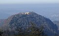
The ruin stands on a witness mountain
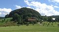
Scharfenberg above the Scharfenhof on the road between Donzdorf and Kuchalb
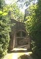
Entrance gate with the coats of arms of Württemberg and Sweden

View from the north into the large residential building
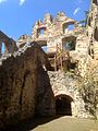
View from the south into the large residential building with wooden stairs to the second floor

Staufer period humpback cubes on the east wall

Renovated residential tower
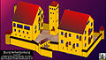
Attempted reconstruction


_-_Rekonstruktionsversuch_(8662122221).jpg)
literature
- Dagmar Zimdars u. a. (Ed.), Georg Dehio (Gre.): Handbook of German Art Monuments : Baden-Württemberg I. The administrative districts of Stuttgart and Karlsruhe . Munich 1993, ISBN 3-422-03024-7 .
- Günter Schmitt : Castle Guide Swabian Alb, Volume 1 - Northeast Alb: Hiking and discovering between Aalen and Aichelberg . Biberacher Verlagsdruckerei, Biberach an der Riß 1988, ISBN 3-924489-39-4 , pp. 157-168.
Web links
- Scharfenberg Castle on burgenreich.de
- Scharfenberg on the website of the city of Donzdorf
- Flight around the Scharfenberg castle ruins
Individual evidence
- ↑ Map services of the Federal Agency for Nature Conservation ( information )
- ↑ a b c Walter Ziegler (Ed.): Staufer sites in the Stauferland. Stuttgart / Aalen 1977, ISBN 9783806201604 , No. 13.
- ↑ a b c Information board in the ruin
- ↑ Günter Schmitt: Burgenführer Schwäbische Alb, Volume 1 - Nordost-Alb: Hiking and discovering between Aalen and Aichelberg. Biberach an der Riß 1988, ISBN 3-924489-39-4 , p. 161.
- ↑ Schmitt p. 162.
- ↑ Schmitt p. 163.
- ↑ Straße der Staufer on stauferstelen.de. Retrieved July 10, 2016.

Castles: Donzdorf Castle | Eybach Castle | Filseck Castle | Helfenstein City Palace | Göppingen Castle | Liebenstein Castle | Rechberghausen New Castle | Stork | Washer lock | Weißenstein Castle | Winzingen Castle | Wiesensteig Castle
Castles and ruins: Aichelberg castle ruins | Berneck castle ruins with Buschel Chapel (Deggingen) | Bühringen Castle | Burgstall Burren | Burgstall Deggingen | Drackenstein Castle | Gruibingen Castle | Helfenstein Castle | Hiltenburg castle ruins | Hoheneybach Castle | Hohenstaufen Castle | Burgstall Hunnenburg | Landsöhr Castle | Leimburg castle ruins | Lotenberg Castle | Mühlhausen Castle (Mühlhausen im Täle) | Oberrommental Castle | Desert tower | Ramsberg Castle | Burgrest Ravenstein | Roggenstein Castle | Scharfenberg Castle | Spitzberg Castle | Staufeneck Castle | Türkheim Castle | Turmberg ruin | Zillenhart Castle