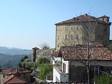
Cantalupo Ligure
| Cantalupo Ligure | ||
|---|---|---|

|
|
|
| Country | Italy | |
| region | Piedmont | |
| province | Alessandria (AL) | |
| Coordinates | 44 ° 43 ' N , 9 ° 3' E | |
| height | 383 m slm | |
| surface | 24 km² | |
| Residents | 451 (Dec. 31, 2019) | |
| Population density | 19 inhabitants / km² | |
| Post Code | 15060 | |
| prefix | 0143 | |
| ISTAT number | 006028 | |
| Popular name | Cantalupesi | |
| Patron saint | Madonna del Carmelo | |
Cantalupo Ligure ( Piedmontese Cantalov , Ligurian Cantalô ) is a municipality with 451 (as of December 31, 2019) inhabitants in the Italian province of Alessandria (AL), Piedmont region .
The municipality consists of the districts Pallavicino, Borgo Adorno, Pessinate, Semega, Campana, Zebedassi, Besante, Arborelle, Colonne, Pertuso, Prato, Merlassino and Costa Merlassino. The neighboring municipalities are Albera Ligure , Borghetto di Borbera , Dernice , Montacuto , Roccaforte Ligure and Rocchetta Ligure .
geography
The place is at an altitude of 383 m above sea level. The municipality covers an area of 24 km² .
Individual evidence
- ↑ Statistiche demografiche ISTAT. Monthly population statistics of the Istituto Nazionale di Statistica , as of December 31 of 2019.
Web links
Commons : Cantalupo Ligure - Collection of images, videos and audio files

