
San Salvatore Monferrato
| San Salvatore Monferrato | ||
|---|---|---|

|
|
|
| Country | Italy | |
| region | Piedmont | |
| province | Alessandria (AL) | |
| Coordinates | 45 ° 0 ′ N , 8 ° 34 ′ E | |
| height | 205 m slm | |
| surface | 31.65 km² | |
| Residents | 4,179 (Dec. 31, 2019) | |
| Population density | 132 inhabitants / km² | |
| Post Code | 15046 | |
| prefix | 0131 | |
| ISTAT number | 006154 | |
| Popular name | Sansalvatoresi | |
 View of San Salvatore Monferrato |
||

San Salvatore Monferrato ( Piedmontese San Salvador ) is a municipality with 4179 (as of December 31, 2019) inhabitants in the Italian province of Alessandria (AL), Piedmont region .
The municipality consists of the hamlets of Fosseto , Piazzolo , Salcido , Valdolenga , Valparolo , Frescondino and San Salvatore Monferrato . The neighboring municipalities are Alessandria , Castelletto Monferrato , Lu e Cuccaro Monferrato , Mirabello Monferrato , Quargnento and Valenza .
geography
The place is at an altitude of 205 m above sea level. The municipality covers an area of 31.64 km² .
Culinary specialties
At San Salvatore Monferrato, vines of the Barbera variety are grown for the Barbera d'Asti , a red wine with DOCG status, as well as for the Barbera del Monferrato .
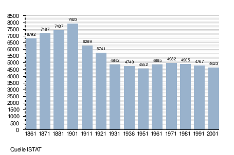
Population development
Web links
- Information at comuni-italiani.it (Italian)
Individual evidence
- ↑ Statistiche demografiche ISTAT. Monthly population statistics of the Istituto Nazionale di Statistica , as of December 31 of 2019.
Acqui Terme | Albera Ligure | Alessandria | Alfiano Natta | Alice Bel Colle | Alluvioni Piovera | Altavilla Monferrato | Alzano Scrivia | Arquata Scrivia | Avolasca | Balzola | Basaluzzo | Bassignana | Belforte Monferrato | Bergamasco | Berzano di Tortona | Bistagno | Borghetto di Borbera | Borgo San Martino | Borgoratto Alessandrino | Bosco Marengo | Bosio | Bozzole | Brignano-Frascata | Cabella Ligure | Camagna Monferrato | Camino | Cantalupo Ligure | Capriata d'Orba | Carbonara Scrivia | Carentino | Carezzano | Carpeneto | Carrega Ligure | Carrosio | Cartosio | Casal Cermelli | Casale Monferrato | Casaleggio Boiro | Casalnoceto | Casasco | Cassano Spinola | Cassine | Cassinelle | Castellania | Castellar Guidobono | Castellazzo Bormida | Castelletto Merli | Castelletto Monferrato | Castelletto d'Erro | Castelletto d'Orba | Castelnuovo Bormida | Castelnuovo Scrivia | Castelspina | Cavatore | Cella Monte | Cereseto | Cerreto Grue | Cerrina Monferrato | Coniolo | Conzano | Costa Vescovato | Cremolino | Denice | Dernice | Fabbrica Curone | Felizzano | Fraconalto | Francavilla Bisio | Frascaro | Frassinello Monferrato | Frassineto Po | Fresonara | Frugarolo | Fubine | Gabiano | Gamalero | Garbagna | Gavi | Giarole | Gremiasco | Grognardo | Grondona | Guazzora | Isola Sant'Antonio | Lerma | Lu e Cuccaro Monferrato
Malvicino | Masio | Melazzo | Merana | Mirabello Monferrato | Molars | Molino dei Torti | Mombello Monferrato | Momperone | Moncestino | Mongiardino Ligure | Monleale | Montacuto | Montaldeo | Montaldo Bormida | Montecastello | Montechiaro d'Acqui | Montegioco | Montemarzino | Morano sul Po | Morbello | Mornese | Morsasco | Murisengo | Novi Ligure | Occimiano | Odalengo Grande | Odalengo Piccolo | Olivola | Orsara Bormida | Ottiglio | Ovada | Oviglio | Ozzano Monferrato | Paderna | Pareto | Parodi Ligure | Pasturana | Pecetto di Valenza | Pietra Marazzi | Pomaro Monferrato | Pontecurone | Pontestura | Ponti | Ponzano Monferrato | Ponzone | Pozzol Groppo | Pozzolo Formigaro | Prasco | Predosa | Quargnento | Quattordio | Ricaldone | Rivalta Bormida | Rivarone | Rocca Grimalda | Roccaforte Ligure | Rocchetta Ligure | Rosignano Monferrato | Sala Monferrato | Sale | San Cristoforo | San Giorgio Monferrato | San Salvatore Monferrato | San Sebastiano Curone | Sant'Agata Fossili | Sardigliano | Sarezzano | Serralunga di Crea | Serravalle Scrivia | Sezzadio | Silvano d'Orba | Solero | Solonghello | Spigno Monferrato | Spineto Scrivia | Stazzano | Strevi | Tagliolo Monferrato | Tassarolo | Terruggia | Terzo | Ticineto | Tortona | Treville | Trisobbio | Valenza | Valmacca | Vignale Monferrato | Vignole Borbera | Viguzzolo | Villadeati | Villalvernia | Villamiroglio | Villanova Monferrato | Villaromagnano | Visons | Volpedo | Volpeglino | Voltaggio