
Coursegoules
| Coursegoules | ||
|---|---|---|
.svg)
|
|
|
| region | Provence-Alpes-Cote d'Azur | |
| Department | Alpes-Maritimes | |
| Arrondissement | Grasse | |
| Canton | Vence | |
| Community association | Sophia Antipolis | |
| Coordinates | 43 ° 48 ' N , 7 ° 3' E | |
| height | 640-1,700 m | |
| surface | 40.98 km 2 | |
| Residents | 531 (January 1, 2017) | |
| Population density | 13 inhabitants / km 2 | |
| Post Code | 06140 | |
| INSEE code | 06050 | |
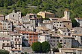
 Evening mood in Coursegoules |
||

Coursegoules is a French commune in the Alpes-Maritimes in the region Provence-Alpes-Cote d'Azur . It is the capital of the canton of the same name in the Arrondissement of Grasse .
geography
The neighboring communities are
- Roquestéron-Grasse and Conségudes in the north,
- Bézaudun-les-Alpes in the northeast,
- Vence in the southeast,
- Courmes in the southwest,
- Gréolières to the west.
Population development
| year | 1962 | 1968 | 1975 | 1982 | 1990 | 1999 | 2008 | 2011 |
|---|---|---|---|---|---|---|---|---|
| Residents | 132 | 134 | 155 | 201 | 260 | 322 | 455 | 484 |
Attractions
See: List of Monuments historiques in Coursegoules

Saint-Barnabé church

Saint-Michel chapel

Sainte-Marie-Madeleine church
The historic center of Coursegoules


literature
- Le Patrimoine des Communes des Alpes-Maritimes . Flohic Editions, Volume 1, Paris 2000, ISBN 2-84234-071-X , pp. 326-329.
Web links
Commons : Coursegoules - collection of images, videos and audio files