
Le Mas
| Le Mas | ||
|---|---|---|

|
|
|
| region | Provence-Alpes-Cote d'Azur | |
| Department | Alpes-Maritimes | |
| Arrondissement | Grasse | |
| Canton | Grasse-1 | |
| Community association | Pays de Grasse | |
| Coordinates | 43 ° 51 ' N , 6 ° 52' E | |
| height | 440-1,689 m | |
| surface | 32.15 km 2 | |
| Residents | 155 (January 1, 2017) | |
| Population density | 5 inhabitants / km 2 | |
| Post Code | 06910 | |
| INSEE code | 06081 | |
 Le Mas |
||

Le Mas is a French commune in the Alpes-Maritimes in the region Provence-Alpes-Cote d'Azur . It belongs to the Arrondissement of Grasse and the canton of Grasse-1 . The residents call themselves Massois. The neighboring communities are Gars and Les Mujouls in the north, Sallagriffon (point of contact) in the northeast, Aiglun in the east, Gréolières and Andon in the south and Saint-Auban in the west.
Population development
| 1962 | 1968 | 1975 | 1982 | 1990 | 1999 | 2005 | 2006 | 2012 |
|---|---|---|---|---|---|---|---|---|
| 41 | 46 | 25th | 120 | 108 | 136 | 130 | 128 | 171 |
Attractions
See also: List of Monuments historiques in Le Mas
- Notre-Dame de Le Mas Church, a Catholic church, registered as a Monument historique since 1937
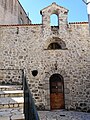
- Saint-Arnoux chapel
- Former castle

Notre-Dame church

Saint-Arnoux chapel with fountain
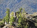
Former castle
Former chapel


literature
- Le Patrimoine des Communes des Alpes-Maritimes . Flohic Editions, Volume 2, Paris 2000, ISBN 2-84234-071-X , pp. 808-809.
Web links
Commons : Le Mas - collection of images, videos and audio files