Dannenberg (Marienheide)
|
Dannenberg
Municipality Marienheide
Coordinates: 51 ° 4 ′ 32 " N , 7 ° 35 ′ 54" E
|
||
|---|---|---|
| Height : | 440 m | |
| Residents : | 335 (Jan 1, 2008) | |
| Postal code : | 51709 | |
| Area code : | 02264 | |
|
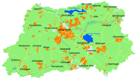
Location of Dannenberg in Marienheide |
||
Dannenberg is a village in the municipality of Marienheide in the Oberbergisches Kreis , North Rhine-Westphalia , Germany .
Location and description
The place is about 6.2 km from the main town.
history
First mention
The place was mentioned for the first time in 1450 , namely "Claes up dem Dannenberg receives with others a privilege for an iron mine in the parish of Müllenbach".
The spelling of the first mention was Dannenberg .
leisure
Association
- Dannenberg village community
regional customs
Since ancient times, the Dannenbergers have been moving to the 900-year-old fortified church in Müllenbach with birch wood torches for the Christmas service.
Hiking and biking trails
The following circular hiking trails lead through Dannenberg.
| Circular / hiking trail | Waymarks | Distance | Path length |
| Circular hiking trail | A5 | Dannenberg - waterfall - observation tower Unnenberg - Dannenberg | 7.8 km |
| Circular hiking trail | A6 | Dannenberg - Genkeltalsperre - Meinerzhagen - House Eistringhausen - Meinerzhagen - Genkel - Börlinghausen - Dannenberg | 9.7 km |
| Circular hiking trail | W. | Holzwipper - Börlinghausen - northwest Dannenberg - Holzwipper | 4.7 km |
Bus and train connections
Public bus
Stop: Dannenberg
- 320 direction Marienheide - Meinerzhagen
- 399 local line traffic Marienheide


