
Fortifications and military installations of Malta

Due to its unique geostrategic location, the Maltese archipelago was almost always the focus of interest from various groups of powers. This has led to the fact that the various owners and occupiers of the island have built a large number of military installations - especially fortifications. The fortifications on Malta illustrate on the one hand the eventful history of the island. On the other hand, in a very compact space they currently offer a unique, almost complete overview of the development of military fortifications from the 16th to the 20th century. The peculiarity - and uniqueness - of Malta is that here the fortification of a complex with coordinated components becomes visible. Similar fortifications in Europe, such as B. Liège or the fortress of Koblenz are only partially preserved, in many areas overbuilt and do not or only with difficulty reveal the context of their components.
Fortifications on Malta before the Order of St. John took possession
Before the occupation, only three areas of the Maltese archipelago were fortified: the city of Mdina in the interior of the island, the citadel on Gozo and the so-called sea fortress (Sea Castle) at the tip of the Birgu peninsula in the area of the Grand Harbor . The Birgu peninsula was probably fortified as early as Roman times. Some of the buildings can be dated to the time of the Arab occupation in the 11th century. Further expansions were made by the Normans from 1091 onwards. The old capital Mdina, also known as "Città Notabile" or "The Silent City" , located in the interior of the island on a hill, was settled by Phoenicians as early as 1000 BC . The current name comes from the occupation by the Saracens around the year 870. The Normans , who conquered the island in 1091 under Roger I , expanded the fortress. The citadel on Gozo was already built by the Romans, later expanded under the Arab occupation and for a long time was the only fortified structure on this island.

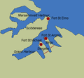
Fortifications on Malta before the Johanniter took possession

Fortifications on Malta in the area of the Grand Harbor before they were taken over by the Johanniter
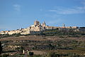
Mdina today

Citadel (Victoria, Gozo)


Fortifications from the time of the Order of St. John (1530–1798)
First fortifications of the Johanniter 1530–1551
Malta was in a key geostrategic position at the time the island was transferred to the Order of St. John . Due to its location directly in front of the North African coast, shipping traffic between the Asia Minor parts of the Ottoman Empire and its North African territories could be controlled from the island . At the same time, the island offered the opportunity to fight piracy along the North African coast and thus to protect the economic interests of the seafaring western and southern European countries. The exposed location made the island vulnerable at the same time. It was to be expected that the Ottomans would try to eliminate Malta as a base. In addition to a sea battle to eliminate the Johanniter fleet , an occupation of the island was just as likely. The new owners took this into account by building extensive fortifications. The Johanniter concentrated on the area around the Grand Harbor . They erected their first buildings east of the Grand Harbor in the area of today's Three Cities. The city of Birgu initially took on the convent of St. John and thus became the de facto capital of the order. To protect the city and the port entrance, the existing Sea Castle was extended to Fort St. Angelo under Grand Master Philippe de Villiers de l'Isle-Adam . The settlement was secured on the land side by a wall. The fortifications in Mdina were also reinforced. During the first Turkish attack in 1551, Mdina and St. Angelo were held, while the citadel on Gozo was occupied by the Turkish troops. This attack, although ultimately successfully repulsed, revealed the weaknesses of the island's defense system.

New buildings and extensions 1530–1551

New buildings and extensions in the area of Grand Harbor 1530–1551

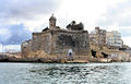
St. Angelo at the top of Birgu


Fortifications of the Johanniter 1551–1565
The landing of the Turkish troops took place in Marsamxett Harbor west of the Sciberras peninsula. The tip of this peninsula was fortified with Fort St. Elmo, named after St. Elmo , the construction of which was initially completed in 1556. This fort thus controlled both access to Grand Harbor and Marsamxett Harbor. In the area of the Grand Harbor, under the Grand Master of the Order of Malta La Sengle , Fort St. Michael was built on the southern of the three land fingers, the Isola peninsula. This fortification was expanded from 1553 to include the city of Senglea , but could not be completed by 1565. The fortress of St. Angelo was strengthened. The construction of these fortifications made it possible to protect the vital harbor area; Overall, however, the system of fortifications still had decisive shortcomings. Fort St. Elmo was lower than the rest of the Sciberras peninsula, the fortified parts of Senglea and Birgus lower than the heights of St Magherita and San Salvadore. A large part of the fortifications was thus exposed to artillery fire from the land side without protection. Fort St. Elmo was therefore completely destroyed during the great siege in 1565 . Although the Turkish attackers were ultimately repulsed in 1565, the existing fortifications did not offer sufficient protection against stronger attackers or a modified, more flexible tactic. It was therefore necessary to expand and strengthen the fortifications.
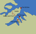
New buildings and extensions in the area of the Grand Harbor 1551–1565
Fort St. Michael, Senglea

Part of the fortress of St Michael at the top of L'Isla


Fortifications of the Johanniter 1565-1630
The great siege had shown the strategic importance of the Sciberras peninsula, which could not be adequately protected by the unfavorably located Fort St. Elmo. It was therefore necessary to fortify the entire peninsula. In March 1566, it was decided to build a fortified city on the peninsula. The city was named after Grand Master Jean Parisot de la Valette . In 1571 the convent of the order was moved from Birgu to Valletta . The city itself included the highest parts of the peninsula and was closed on the land by the Valletta Land Front. It was designed by Francesco Laparelli . Many of the most important buildings were built by Gerolamo Cassar . At the same time, Fort St. Elmo was rebuilt. With the victory of the united fleets in the naval battle of Lepanto , the maritime balance shifted to the detriment of the Ottoman fleet. The fleets of the North African states were no longer part of the Ottoman fleet and were limited to piracy. The danger of a new siege seemed to be averted for the time being. This changed with the loss of the Spanish Armada in 1588, which shifted the maritime balance in the Mediterranean back in favor of the Ottoman fleet.
New buildings and extensions in the area of the Grand Harbor 1565–1630

Valletta with St. Elmo at the top, unknown artist around 1800

Valletta south side


Fortifications of the Johanniter 1635-1800

Floriana Lines
In order to keep Valletta and Fort St. Elmo out of the fire area of enemy artillery as much as possible, the fortifications were moved inland in the 17th century. The construction of the Floriana Lines , named after the Italian-born Grand Master Pietro Paolo Floriana, began in 1635. However, the enormous costs of this structure proved to be critical. In addition, occupying the fortifications with sufficient troops seemed difficult, so that their completion was repeatedly delayed.
Sta Magherita Lines
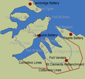
The landside fortification of the three cities (Birgu was renamed Città Vittoriosa, Senglea into Città Invicta) east of the Grand Harbor by the Sta Magherita Lines began around the same period. The St. Magherita Lines included the heights of the same name and eliminated the endangerment of the Three Cities from them. The enormous expenditure for these fortifications by far exceeded the financial means of the order, so that there were repeated interruptions to the construction. Ultimately, both the Floriana Lines and the St. Magherita Lines could not be completed until the 18th century.
Cotonera Lines
The Cotonera Lines moved the fortifications of the Three Cities land again. Like the Floriana Lines, they were supposed to protect the actual main fortifications from enemy artillery fire and keep the enemy away from them as long as possible. However, the area gained could also be used to expand the cities east of the Grand Harbor. Considered the most demanding project at the time of the Order of St. John, construction began under the direction of the Italian fortress builder Antonio Maurizio Valperga in 1670. They were named after Grand Master Nicholas Cotoner. A simplified version of the planned fortifications could not be completed until 1760.

Fort Ricasoli
Also in 1670, the construction of Fort Ricasoli began under the direction of Valpergas . Located on the northernmost of the three land fingers, it, together with Fort St Elmo, protected the entrance to the Grand Harbor. From this point the Turkish artillery fired at both Fort St Elmo and Birgu during the great siege. Fort Ricasoli thus contributed significantly to strengthening the existing fortifications.
Since the knight Giovanni Francesco Ricasoli financed a large part of the project, the fort was named after him. The construction was completed in 1698.
Fort St Elmo

The fort was designed around 1522 by the Spanish fortress builder Pedro Pardo. It was a star-shaped structure that had been erected on the top of Monte Sciberras, which had the disadvantage that the rocky headland of Monte Sciberras was considerably above the fort, so that enemies could see in from above and also fire into it. The fort was completely destroyed during the siege by the Turks in 1565 and only rebuilt during the construction of Valletta .
Fort St Elmo was expanded between 1687 and 89. The outer fastening ring with bastions to accommodate guns was added.
Fort Manoel
While the fortifications in the area of the Grand Harbor were constantly being expanded, Marsammxett Harbor was originally only protected by Fort St Elmo and the western fortifications of Valletta. However, these fortifications could not seriously prevent the occupation of the port by enemy troops. Fort Manoel, named after the Grand Master Manoel de Vilhena (1722–1736), was therefore built on the island in the middle of the port to protect this port area . Construction began in 1723. Until then, the island served the Order of Malta with the hospital founded in 1643 as an isolation and quarantine station, for u. a. Lepers and incoming ships under the yellow flag . Fort Manoel represents the climax and also the conclusion of the classic fortress construction on Malta. The actual fort had a rectangular floor plan. At the corners of the fortress there were strong bastions that were used to hold the main armament. These bastions were protected by countreguards in front of them. The entrance to the fortress, secured by a drawbridge, was on its east side.
Fort Tigné
The last fortification built by the Hospitallers was Fort Tigné, which, west of Fort St. Elmo, covered the entrance to Marsammxett Harbor. Construction under the direction of Stefano de Tousard began in 1792 and completed in 1794. Although very small, Fort Tigne has an extraordinary new design and is described as the most revolutionary and influential fortification ever built by the Knights. In contrast to all other forts built by the Hospitallers, this fortress had a diamond-shaped floor plan. The walls of the actual fortress were on the same level as the surroundings. The fortress was completely enclosed by a wide and deep moat, which in turn was closed off from the outside by a wall. In the corners of the outer wall there were strong trenches with a multitude of loopholes in order to keep the trench free from enemy forces by massaging musket fire. The accommodations and storage facilities were located in a building that ran diagonally inside the main fortress and whose flat roof also closed off with the surrounding area. Access to the fortress was through a tower in the southwest corner of the fortress, the only building that rose significantly above the area. The main armament was stationed in batteries on the walls of the inner fortress. Six cannons each fired north and west, five east and three south. The armament was reinforced with eight smaller caliber cannons and six mortars. This construction, which was adapted to the terrain, offered maximum protection against the effects of enemy weapons. Since the main walls were on the same level as the surrounding area, they could not be destroyed by artillery. At the same time, the defenders were able to send massive artillery fire in all directions. Fort Tigné's construction represents the transition from bastional to polygonal fortress construction and anticipates the developments of the 19th century.

Fort Tigné, original condition, schematic representation

Fort Tigné, original state, cross-section, schematic representation

Wignacourt Towers
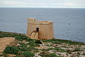
The focus of the fortifications was initially in the Grand Harbor area. This was logical, as the most important institutions of the order were located here with the port, the hospital, the knights' inns, the convent and the grand master's palace. In addition, the Ottomans landed their troops in this area in both 1551 and 1565. However, there was also the possibility of a sea landing in other areas of the island or on Gozo. Two cases were assumed to be probable: on the one hand the landing of a large siege force, which would then line up to conquer the port area from the land side, on the other hand raid-like actions by the corsairs . Although not threatening the port area, they could cause considerable damage and seriously disrupt the supply of the island. The deportation of the island's indigenous population into slavery would make the island uninhabitable in the long term and thus endanger the position of the Johanniter as a whole. While the landing of a large siege force could not be averted at first, or only with disproportionately great effort, there were certainly possibilities to protect yourself against attacks by pirates. Basically, two approaches were possible: either the enemy was caught and defeated at the place of landing, or only after the landing by called-up troops. The second solution required, in addition to organized reconnaissance, which at least made permanent observation of possible landing sites necessary, well-developed communication structures and mobile, powerful land forces. Therefore, the first approach was turned to. The endangered areas should be secured by fortifications. The first row of the so-called Wignacourt Towers was built between 1609 and 1649: St Lucians Tower (1610/11) in the bay of Marsaxlokk , St Thomas Tower (1614) and Sta. Maria delle Grazie (1620) on the flat beaches of the southeast coast, St. Pauls Tower (1609) in the Bay of St. Paul and Mellieha Tower (1649) in the Bay of Mellieha. The Gozo Canal and thus the access to the north coast of Malta or the south coast of Gozo was monitored by St Mary's Tower (1618) on Comino , while Gozo itself was secured by two towers in Marsalforn (1616) and Mgarr (1609). All of these towers were built according to a uniform scheme. They had a square floor plan and usually had two floors. The main armament of the turrets stood behind a parapet on the roof.
In addition to the defense of the corresponding stretch of coast, these towers also served for communication. In the event of danger, flags should be set, cannons fired or a fire lit at night. These signals were to be passed on from the other towers, and from Mdina and Citadella all parts of the respective island and thus all towers could easily be overlooked. The towers were named after the Grand Master Alof de Wignacourt , under whose aegis the construction of the towers began.

St. Lucien Tower

St. Thomas Tower


Lascaris Towers
The island's fortification system was supplemented by other, smaller watchtowers. Its construction began in 1630 and continued until 1647. The towers were built in Ghajn Tuffieha , Lippija , Qawra Point , St. Georg's Bay and Wied iz-Zurrieq . They were mostly built in places where a landfall was conceivable, but access to the interior of the island was difficult due to the nature of the terrain. Compared to the Wignacourt Towers, they were much smaller. Their main purpose was observation and alerting. The reason was the resources of the order, which did not allow the manning of a sufficient number of larger towers. It is documented that these towers were equipped with smaller cannons, which could mainly be used for signaling and less for defending the towers.

Qawra Tower

Redin Towers
Under the rule of Grand Master Fra ′ Martin de Redin , the coastal fortifications were strengthened again and the thirteen so-called Redin Towers were built: Delimara , Wardija , Hamrija , St Julian's Tower , Qalet Marku , Ghallis , Madliena Tower , Bengisha , L'Ahrax , Triq-il -Wiesga , Xrop l-Ghagin and Ghajn Hadad . These towers were intended to close the remaining gaps in the island's defense system. They were built according to the same scheme as the Lascaris Towers , but some of them were larger and had an additional floor. At least some of these towers had four equally large turrets on the roof. The Redin Towers were supplemented in 1661 by the Mgarr-ix-Xini tower on Gozo and in 1667 by the ta'Isopu tower near Nadur . In the period that followed, the conceptual approach to coastal defense changed. It was planned to allow enemy forces to land and to confront and beat the enemy inside the island. Therefore, no more towers were built for almost 100 years until the conceptual approach changed again in the second half of the 17th century and the enemy was prevented from landing or beaten on the beaches. It was not until the tower at Marsalforn was erected in 1760 that such fortifications came to an end.
Tower ta'Isopu (Gozo)

Coastal batteries and field fortifications
As already shown, the conceptual approach to averting a sea landing changed between 1660 and 1760. No more towers were built during this period, but coastal batteries and additional field fortifications began to be built in the first half of the 18th century. These were based on the idea that an enemy would drop anchor and disembark their troops in the bays of Marsaxlokk, Marsaskala, St. Julian's, St. Thomas, Madliena, St. Pauls and Melhiella as well as on the north coast across from Comino could without being substantially hindered by the existing fortifications. Once such an enemy had disembarked and developed their forces, they would not have been stopped until the fortifications of Grand Harbor. The towers built up to now offered a certain protection for their crews and could serve as a communication platform, but had too little firepower. Infantry weapons in particular could hardly be used from them. Therefore between 1715 and 1792 a total of 34 coastal batteries were created, which were supplemented by 20 redoubts for infantry. The terrain level running from west to east in the northern part of the island should also be used for defense purposes. Although it was a strong obstacle, it had some loopholes near Naxxar , Falca and Bingemma that could be exploited by an attacker. Therefore it was decided in 1722 to close these gaps and to build a field fortification near Mdina. In the following year the installation of field fortifications on the bays of Marsaxlokk and St. Julian's was ordered, from 1731 the Falca Lines were built. However, the work was slow and was finally canceled in 1773. Plans to build another 30 coastal batteries or a wall to completely enclose the islands of Gozo and Malta were never realized.
Sea landings and raids between 1565 and 1798
After the defeat during the great siege of 1565, the Ottomans made no further attempts to conquer the islands. Only in 1614 about 60 ships put 5000 men ashore in St. Thomas Bay, but the attack could be repulsed with minor losses. In contrast, minor attacks by Muslim pirates were relatively frequent. Although the period from 1614 to 1798 seems relatively peaceful, the threat from the Ottoman fleet and its allies was always present. An invasion in 1635, 1640, 1645, 1714, 1722, 1731/32 and then again in 1760/61 was feared. This latent danger drove the Johanniter to the constant expansion and perfecting of their fortifications. Towards the end of the 18th century these had reached a level that, although not completely preventing the constant raids by pirates, was able to minimize their consequences. A major invasion could either be repulsed or the ensuing siege endured for a long time. It can be assumed that the strength of the fortifications had a deterrent effect on potential attackers and contributed to the relatively peaceful development in these almost 180 years.

French occupation 1798–1800
French conquest in June 1798
Napoleon Bonaparte planned a campaign in Egypt against British troops in 1798 . For this purpose a fleet consisting of 13 French and 2 Venetian ships of the line , 14 frigates and a total of 400 transport ships was put together. A total of 36,000 soldiers embarked on it. The French fleet, which had left the port of Toulon in May 1798, reached Malta on June 9, 1798. There it grew to around 500 ships. The landing of the French troops began on the morning of June 10th. As anticipated, the troops were brought ashore in the bays in the north and south of the island classified as endangered.
General Louis Charles Antoine Desaix landed in the bay of Marsaxlokk and then turned towards Valletta after overcoming the fortifications there. General Claude-Henri Belgrand de Vaubois landed in St. Julians Bay. He was to take Mdina with part of his troops, while another part should also turn against Valletta and attack the city from the north. The attack on Mdina was supported by General Louis Baraguey d'Hilliers , who landed in Mallieha and St. Pauls Bay. Part of his troops were assigned to pan north and secure the banks of the Gozo Canal. Gozo itself was taken by General Jean-Louis-Ebenezer Reynier , who landed in San Blas Bay. A total of 15,000 troops were brought ashore. The Johanniter and their local auxiliaries did not offer any resistance, so that a large part of the island was occupied by the afternoon of June 10th. The surrender negotiations began the morning of the following day.
The French plan of operations had proven the expediency of the fortifications of the Johanniter. The landings took place in the areas that were assessed as suitable and were accordingly strongly fortified. However, since neither the Johanniter nor their Maltese auxiliaries were ready to fight the French troops, a landing could not be prevented even with these fortifications.
Trench warfare June to September 1798
After the surrender of the Hospitallers, the fleet started moving again towards Egypt. Only 3,000 French remained on the island, including 5 batteries of artillery that occupied the fortifications at Grand Harbor. Immediately afterwards, the indigenous population of the island, upset by the rapid deterioration of their economic situation and unpopular measures by the occupying forces because they were directed against the Catholic Church, defended themselves against the French. The Maltese auxiliary troops recruited by the Hospitallers, who, in contrast to them, had remained on the island, joined the uprising of the population. The Maltese were able to muster a force of 10,000 men, but only a quarter of them were adequately armed. Guns were obtained from the coastal fortifications. Insufficiently trained and armed, the Maltese armed forces were only able to block the French troops, but could not bring about a decision. To prevent an outbreak of the French, the Maltese put some field fortifications around the Grand Harbor and Valletta . This trench war also confirmed the strategic vision of the Johanniter. The fortifications they built were strong enough to withstand even a numerically superior enemy.
Conquered by the British in September 1798 to July 1800
In September, a British squadron led by Captain Alexander Ball reached the island. Ball blocked the port and dropped 500 British and Portuguese marines ashore. However, this small number was unable to provide significant support to the Maltese troops. In December 1799 these troops were reinforced by another brigade under British command, but it was only with the landing of 1,500 soldiers in July 1800 that the balance of power changed in favor of the British and the Maltese. However, these troops were not enough to storm the fortifications held by the French in the port area. The ongoing blockade cut off the French troops from supplies. After the defeat of the French troops in Egypt, there was no longer any hope of relief. On September 4th, the French troops surrendered to the British, the Maltese were neither involved in the negotiations nor in the surrender. Securing the island as an important link in the Gibraltar - Malta - Egypt chain and the associated control of the eastern Mediterranean weighed more heavily than the interests of the Maltese people. Fifteen years after the occupation, Malta became a British crown colony . During this period, too, the fortifications proved to be superior to any attacker. At the same time, however, it became clear that the island could not be held in the long term without external support. Even without storming its fortresses, the island had to fall sooner or later after a consequent sea blockade.
British occupation 1800–1964
Fortifications 1800 to approx. 1860
The British armed forces initially continued to use the fortifications as well as the armament and equipment of the Crusaders and the French. In the area of the ports alone, the British took over 598 cannons, 49 mortars and 10 howitzers. There were also about 300 cannons on the rest of the main island, Gozo and Comino. However, the different types led to enormous problems with the ammunition storage. This fact was recognized relatively early on, but was not remedied during the first 60 years of the British occupation. Initially, the threat to Malta was assessed as relatively high - revolutionary France continued to lay claim to the island - but it sank rapidly after the end of the wars of liberation. The waters around Malta were ruled by the Royal Navy's Mediterranean fleet stationed in Grand Harbor . This was seen as the best protection against invasion, consistent with British military theory at the time. The lack of threat and the focus of British interests on other regions - Crimea , India , etc. - meant that a thorough modernization of the fortifications in Malta and their armament was not considered necessary. It was limited to improvements to the existing fortifications. One focus of the efforts was on the completion of the Cotonera Lines to protect the Grand Harbor from attacks from the east. At the same time, the space between the Cotonera Lines and the Sta Magherita Lines was divided into two halves by the St. Clements Retrenchment in order to avoid the Cotonera Lines being cut by an attacker. The central bastion of the Sta Magherita Lines was strengthened and expanded into Fort Verdala. This work was completed in 1849.

New buildings and extensions in the area of the Grand Harbor 1800–1860

6 pounder guns. Such cannons were typical of Malta in the first half of the 19th century

View of the Lascaris Battery

Lascaris Battery below Upper Baracca Garden

View from the Lascaris Battery to Fort Ricasoli. The battery's dominant position in Grand Harbor becomes clear


Fortifications from 1860 to around 1900
Cont
The development of cannons that fired grenades in 1837 (up to then cannons had mainly fired full projectiles) set in motion a rapid development in the field of artillery, but also in shipbuilding and fortification. The development of rifled gun barrels (1842) led to a significant increase in the range and accuracy of the artillery. The existing wooden sailing ships were inadequately protected against these weapons. This led to the development of steam-powered, armored ships, which in turn were armed with new, large-caliber cannons with rifled barrel. The coastal fortifications that had been erected by then proved to be largely useless against these new types of weapons. This also led to the development and construction of new types of fortifications in Malta. First the fortresses Fort St Elmo , Fort Tigne and Fort Ricasoli in the area of the Grand Harbor and its entrances were equipped with modern weapons. Between 1872 and 1878 the fortifications of Fort Sliema (1872), St. Rocco (1873), Fort St Lucian (1874), Fort Pembroke (1875), Fort St Leonardo (1875), Delimara (1876) and Tas-Silg (1879) were built ) newly built. Basically, these are polygonal (polygonal) fortifications, the walls of which - as with Fort Tigne - were mostly at about the same level as the surrounding area and secured by systems of ditches. The trench, in turn, was secured by digging. The main armament consisted of only a few large-caliber guns, and the crew, ammunition and supplies were housed in casemates .
New buildings and extensions in the area of Grand Harbor 1860–1910

Fort Tigne, British extensions, schematic diagram

Fort Delimera Marsaxlokk


.jpg)
Coastal batteries 1878/79
At the same time, a number of coastal batteries were built. The Cambridge Battery (west of Fort Tigne) was built in 1878, the Rinella Battery east of Fort Ricasoli was built in 1879. In contrast to the forts, they only served to accommodate a single gun, its operation and ammunition. The floor plan was pentagonal, the wall was as high as the surrounding area and was only secured by a wide moat. In the trench itself there were a total of three trench strokes in the northern part at the corner points of the polygon. Both batteries were each equipped with the so-called 100-ton cannon with a caliber of 450 mm . It was able to fire shells with a projectile weight of 907 kg every 5 minutes at a distance of 5900 m. These cannons were designed and built by the UK Elswick Ordnance Company . In 1874 the Italian Navy equipped its two newly built ironclad ships " Caio Duilio " and "Enrico Dandolo" with these guns. With their heavy armor and armament, they posed a serious threat to the British Mediterranean fleet and the fortifications in Malta.
At the same time, the strategic importance of Malta had increased significantly with the opening of the Suez Canal in 1869. Malta was an important station on the supply route Great Britain - Gibraltar - Suez - India and also experienced a growing importance for merchant shipping. Securing these vital sea routes made a strengthening of Malta inevitable from the British point of view.
The cannons were mounted on a barbette weighing 45 tons. For loading they were withdrawn from their firing position, the barrel was lowered and swiveled 90 degrees to the right or left to the side. The pipe was then loaded from the front from a bunkered charging station. 250 kg of propellant charge and the projectile were pressed into the barrel with a hydraulic ram. The tube was then turned again and moved back into the firing position.
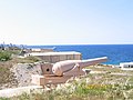
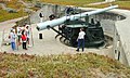
The 100-ton Armstrong cannon in the Rinella Battery

Loading opening to the right of the cannon
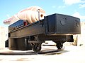
Barbette the cannon

Grenade caliber 17.72 inch


Victoria Lines
While the area around Grand Harbor and the southern part of the island were relatively well fortified, the island in the area of St. Pauls Bay was largely unprotected against a sea landing, as the fortifications of the Johanniter no longer met modern requirements and were partially dilapidated. However, the topography and extent of the area, in connection with the relatively short range of the artillery at the time, made it impossible to build fortifications similar to those in the south of the island. Since the landing of enemy troops in the northern part of the island could not be prevented, they had to be stopped at the entrances to the strategically important port areas. The British military took up a plan by the Crusaders to fortify the sloping slope of the ridge that runs across the island. Work on this fortification began in 1875. On the occasion of Queen Victoria 's 50th anniversary of the throne expected in 1897 , this fortification was named Victoria Lines .
As the first part, Fort Bingemma was built in 1875 to protect the left flank of the planned fortification. Fort Madliena, built in 1878, performed the same task on the right flank. Fort Mosta (1880) served to protect the center. The fortifications were completed by Fort Pembroke, which was used for coastal defense and closed the gap between the eastern end of the Victoria Lines and the fortifications in the Grand Harbor area. The line itself consisted of a 1.5 m high quarry stone wall. Positions for artillery were provided. The infantry took up their position directly behind the wall and watched or fired through loopholes. Since the lines spanned a number of dried up river valleys, which drained enormous amounts of water during heavy rainfall, bridge-like constructions were planned here.
The further development of infantry armament, in particular of multi-loading and machine guns, as well as the development of field artillery, however, quickly made the use of the Victoria Lines appear doubtful. As early as 1900, the lines were broken during an exercise by the attacking troops, so their use was abandoned in 1907.
Fort Madliena is a typical example of the construction of the time. The fort itself consisted of two parts: the actual fortress and a part immediately to the north to accommodate the main armament. Both parts were surrounded by a wide and deep trench and separated from each other by a similar one. The walls of the fortress were below the level of the surrounding area or were only slightly elevated, only in the south-eastern part, where the entrance to the fortress is, they are significantly higher. Through the construction of the trench system with trench sections intersecting at right angles and trench strokes, massed, usually flanking and thus destructive infantry fire could be directed at an enemy who had penetrated. The main armament - two 152 mm cannons - were in an open firing position in the northern part of the fort. They could each be pivoted 270 degrees to the side. The initially mounted muzzle loading cannons were pneumatically lowered for reloading. For this purpose and to raise the cannons into the firing position, the energy of the recoil of the cannons was used, which compressed air in a piston. While the ammunition depots in the northern part were underground, accommodations and other storage areas were in the inner courtyard of the southern part. The construction of the fort allows the main task - coastal defense or the fight against landed forces - to emerge clearly, while the all-round defense is neglected. It is aimed at maximum protection against the effects of enemy weapons while at the same time massaging the fire in the main direction of fire. Such a fastening cannot be held on its own in the long term, it is part of a system of fastenings that are coordinated with one another. The Victoria Lines fortifications are a clear example of the transition from stand-alone individual fortifications (the Johanniter towers) to a fastening system made up of geographically isolated components that are coordinated in terms of protection and effectiveness. A similar system from this period is used in Germany e.g. B. with the fortress Koblenz partially preserved.

Victoria Lines

Fort Madliena, schematic representation

British 8 inch (203.2 mm) muzzle loading gun in firing position


Corradino Lines
Beginning in 1878, the fortifications in the southern part of the Three Cities east of the Grand Harbor were reinforced. The Corradino Lines initially ran eastward from Grand Harbor, then turned sharply to the northeast and reached the Cottonera Lines at the level of St. Pauls' Bastion. The fortification itself consisted of a total of four two-story galleries, which were protected by a trench ten meters deep and eight meters wide. The lower gallery was at the level of the trench and was equipped with positions for carronades (large-caliber, short- barreled weapons), while the upper gallery had loopholes for the infantry. Just like the Victoria Lines, the Corradino Lines were overtaken by technical developments and abandoned from 1907.

Carronade

Coastal batteries 1881/82
After the completion of the Rinella or Cambridge Battery, another series of coastal batteries was built in the south of the island: 'St. Paul's Battery (St. Thomas Bay, 1881) and Żonqor Battery (Marsaskala, 1882). These batteries were also equipped with muzzle-loading guns, but here of a smaller caliber.
Coastal batteries 1888–1910
At the end of the 19th century breech-loading cannons were ready for use. At the same time, with concrete , in particular reinforced concrete , a material for fastenings became available which had decisive advantages over the broken stones and bricks previously used in terms of strength, shape and construction effort. These developments led to the construction of a number of new coastal batteries in Malta. These batteries were generally equipped with 9.2 inch (234 mm) or 6 inch cannons. This is Delle Grazie Battery (east coast between Fort St. Rocco and Fort St Leonardo , 1889), which, contrary to the above standard, was initially equipped with 10 inch (254 mm) cannons, Spinola Battery (between Grand Harbor Area and Fort Pembroke, 1889), Garden Battery (between Cambridge Battery and Fort Tigne, 1890), Pembroke Battery (west of Spinola Battery, 1897), Wolseley Battery (south coast, 1897) and Fort Bengisha (south coast, 1910). The Wolseley Battery is the first fortification in Malta that was provided with machine gun positions and barbed wire obstacles. In this respect, together with Fort Bengisha, it represents a transition to the fortifications of the twentieth century.
The main armament of the batteries was now mounted on a 360 degree rotating mount, the elevation range was +15 and -10 degrees. The constructive design as a breech loader made reloading in the firing position possible, so the previously used, complicated mountings of the 9.2-inch cannons, which enabled the cannons to be pneumatically lowered for reloading, could be omitted. The 9.2-inch cannons were intended to defend against larger surface units, while the 6-inch cannons were intended to defend against torpedo boat attacks.
The structure of these batteries followed the example of the Rinella or Cambridge Battery; Floor plan and construction are almost the same, only the installed main armament is different. During the Second World War , the existing coastal fortifications were partially equipped with more modern weapons and provided with additional, bunkered observation posts and machine gun positions, but otherwise remained unchanged. They proved their effectiveness in repelling the Italian speedboat attack in 1940 when they succeeded in destroying all attacking Italian speedboats.
British 6 inch breech loading cannon

British 9.2 inch breech loading cannon

Fortifications 1910–1945
Fortifications
The further development of military technology, but especially the experience of the First World War , led to a changed approach to the construction of fortifications. The invention of the machine gun made it possible to stop numerically superior attackers with a relatively small amount of force. Sir Georg Sydenham Clarke stated:
"In the special qualities of the machine gun there is a distinct advantage to the defense, arising from that fact that a few men occupying a small space can suddenly develop an intense fire over a particular area."
Fortifications could now be built much smaller and looser without losing their combat value. The experiences of the First World War, in particular the capture of Liège, Antwerp and Manonville, again showed that conventional fortifications could only withstand strong artillery fire for a very short time.
The future of field fortifications was described by Colonel Kelly as follows:
"Zones of defense, without large permanent works ... Within these zones the fortifications will not take the form of elaborate forts, but will consist of dispersed and concealed tank-proof localities, with the intervals between them well covered by obstacles and the fire of all arms. "
As a result, only two large fortifications were built in the 20th century, which differed significantly in their structure from previous fortifications. These fortifications are Fort Campell in the north of the island and Fort Benghisa in the extreme south. Fort Campell was built in 1937 as the last large field fortification. It was used to hold a total of three 152 mm cannons for coastal defense in the open position. The actual fortification of the fort consisted only of a thin, relatively low wall, which was interrupted by fortified machine gun and rifle positions. The accommodation for the fort's crew, as well as ammunition and other storage rooms, were located in the southern part of the fort. Overall, emphasis was placed on adapting to the surrounding terrain as closely as possible in order to reduce visibility from the air as much as possible. Although officially referred to as a fort, this is more of a coastal battery than a fortress.

These two large fortifications were reinforced by a series of machine-gun bunkers. These machine-gun bunkers were built in areas where landings had already taken place or were expected. Therefore, they are very often located near the fortifications of the Johanniter. Examples of such MG bunkers can still be found near the White Tower and the Blue Grotto.
Immediately after the outbreak of the war, more machine-gun bunkers were built in the central part of the island, here in particular on the Marfa Ridge, but also at St Pauls Bay and Mellieha Bay.
These MG bunkers have a square floor plan and have two floors inside. The reinforced concrete ceiling was 381 mm thick, the side walls made of the same material 254 mm. Access was through a steel door on the ground floor. The main armament, usually two water-cooled Vickers machine guns , fired through diagonally opposite slots on the first floor. Both floors were also provided with loopholes, which, like the slots for the machine guns, could be closed with sheet steel panels. The fire was directed by an observer who found his place in a slotted turret on the roof of the building. The crew consisted of this observer and one gunner and one loader for each machine gun. These bunkers could develop enormous firepower against dismounted enemies, but were ineffective against armored vehicles. They were unprotected against direct hits from heavy artillery. Protection against the use of warfare agents could only be ensured by the gas masks of the crew. The crew of these towers was able to repel weak enemies and stop stronger enemy forces, but required the support of the coastal artillery.
Airfields
The further development of military aircraft, but above all their intensive use in the First World War and the theories about aerial warfare ( Giulio Douhet , Billy Mitchell, etc.) developed from various sides in the 1920s, brought the use of military aircraft and the island's air defense to the fore Interest.
A surveillance of the extensive sea areas around Malta was initially only possible with flying boats or sea planes. Therefore, the Kalafrana Flying-Boat Base was set up in the south of the island as early as 1916. With the increase in the flight performance of land planes, but also the need for an air defense of the island, the establishment of land airfields became necessary.
The first to be established was Hal Far airfield in the southwest of the island in 1922. Hal Far was operated by the Fleet Air Arm , was the largest airfield on the island until the 1950s and eventually had two intersecting runways made of concrete. Runways and parts of the airfield facilities are still preserved and are partially used as a racing track.
The third airfield, Luqa Airfield, was built by the RAF Bomber Command before the start of World War II . Luqa is still in use today and, after several renovations, is now the only commercial airport on the island . During the Second World War, the existing airfields were added. In 1940 Ta 'Qali ( Fighter Command ) was built in the central part of the island . This airfield has been abandoned, parts of the preserved infrastructure are home to the Ta 'Qali Crafts Center and a museum. The location of the runway and part of the taxiways can still be seen today.
In the southern part of the island, the airfields Qrendi / St. Niklaw (1940) and Safi (1942), both also abandoned today. Both airfields only had a narrow, unpaved strip of land and can no longer be seen today. The Xewkija airfield was built on the island of Gozo by US troops in 1943 . It is also no longer used.
Airfields 1916–1945

Gloster Gladiator Faith on the Ta'Qali airfield


Air defense systems
Due to the location of Malta - around 90 km south of Sicily - the threat posed by the Italian Air Force was assessed as very high, as the flight time from Italy to Malta was only around twenty minutes. This gave rise to the problem of air reconnaissance for the island's air defense.
An acoustic early warning system known as Il-Widna (the ear) was built near the village of Għarg Ortur in 1934/35 . This was a concrete structure in the form of a parabolic mirror that reflected the sound waves emitted by the aircraft and bundled them at the focal point of the mirror. In practice, reconnaissance ranges of 34 to 36 km were demonstrated in 1935, which allowed Malta to have an advance warning time of around 5 minutes. Disadvantages were the high cost of materials, the inability to lay the system and the fact that the sound signals could only be received from a certain direction that could not be changed during operation. With the development of radio measurement technology , however, reconnaissance devices could be developed that did not have the disadvantages described, so that only one of the five systems originally planned in Malta was built. Similar plants were in the British Isles ( Kent and Yorkshire ). As already mentioned, from the end of the thirties onwards the development of radio measurement technology enabled extensive and complete air space reconnaissance. Before and during the Second World War, a total of six radar stations were set up on Malta . The first three radar stations were set up in March 1939. For reasons of secrecy, they were called AMES - Air Ministry Experimental Station. They are the 241 AMES at the Dingli Cliffs (successor still in operation today). This station was able to detect soaring aircraft. The 242 AMES was set up in Ghar Lapsi in June 1940 to investigate low and medium-high flying targets . To combat incoming aircraft, 34 heavy and 8 light AA batteries were available at that time, which were supplemented by 24 searchlights for target illumination. For example, several heavy 3.7 inch AA guns were installed in Fort Manoel. In mid-1941 the existing radar stations were supplemented by the 501 AMES in Tas Silg , the 502 AMES in Madliena and the 504 AMES in Dingli . A command post near Salina Bay served to guide the fighter pilots. In February 1942 two more radar stations were operational on the 521 AMES on Gozo. The reconnaissance system was supplemented by radio reconnaissance units for eavesdropping on radio traffic from the Italian and German armed forces, as well as a liaison command at HQ in Valletta, which had access to ultra information and provided information for decryption in Bletchley Park . The island's air defense as a whole was derived from the Lascaris War Rooms (below the Lascaris Battery in Valletta). Operation Husky was also prepared and conducted from here in 1943 .

Airspace reconnaissance systems 1935–1945

Radar station on Dingli Cliff, as it is today

British 3.7 inch anti-aircraft gun


Development after the Second World War
After the end of the Second World War, the fortifications on Malta quickly lost their importance. On the one hand, the geostrategic situation of Malta had fundamentally changed due to the integration of Italy into the North Atlantic Alliance ( NATO ); on the other hand, the mobile battles of the Second World War had shown the limits of stationary fortifications. The development of tactical missiles, air-to-ground weapons and long-range mobile artillery also made coastal batteries unnecessary. The existing fortifications were abandoned or used for logistical purposes. Only the airfields and radar systems initially remained in use. However, the development of jet aircraft required longer runways and the establishment of a corresponding ground-based infrastructure. The small size of the island, but also the high costs of building and maintaining this infrastructure, led to a reduction to initially two ( Hal Far and Luqa) and finally one airfield (Luqa).
After the last British troops had withdrawn from the island, the only remaining flying units were those of the Armed Forces of Malta . However, the size and equipment of these units do not require a complex military infrastructure, so that Luqa Airport is only used by them. Although Malta had or has concluded defense agreements with both Libya and Italy, the stationing of foreign air forces on the island was not planned.
The radar systems at Dingli Cliff as well as parts of Fort Pembroke, where Italian armed forces are stationed (Italy has guaranteed the sovereignty of Malta and provides military support), are therefore among the last military systems on the island that are still in actual use . In Fort Madliena or in the immediate vicinity there is a training facility of the Navy of the Armed Forces of Malta and a radar installation for monitoring the sea and air space around the island. St. Mary's Tower on Comino is also still used by the Armed Forces of Malta. The accommodations of the flying units of the Armed Forces of Malta are in Hal Far. Parts of the Maltese Navy are still stationed on Manoel Island, but not in the actual Fort Manoel. Part of the military facilities was or is being developed for tourist purposes. Another part is no longer accessible to the public or has been sacrificed to various building projects. So is z. B. in the former Pembroke Battery a multi-water desalination plant. Cambridge Battery has been converted into a club with a swimming pool but is closed due to ongoing construction. The surrounding barracks from British times were demolished and the area built over with hotels and apartment blocks.
See also
literature
- Ernle Bradford : The Shield of Europe . Ullstein Buchverlag, ISBN 3-548-34912-9 (from the English, title of the original edition The Great Siege, Malta 1565 ).
- Baedeker : Malta . 5th edition, 1999/2000, ISBN 3-87504-544-0 .
- Tony Spooner: Faith, Hope and Malta GC. Ground and Air Hereos of the George Cross Island. Grécy Publishing Limited, 2008, ISBN 978-0-907579-58-8 .
- Charles Stephenson: The Fortifications of Malta 1530-1945 . Osprey Publishing Limited, 2004, ISBN 1-84176-836-7 .
- Sir George Sydenham Clarke: Fortifications: It's Past Achievments, Recent Developments, And Future Progress . Beaufort Publishing, 1890.