
Bex
| Bex | |
|---|---|
.svg) |
|
| State : |
|
| Canton : |
|
| District : | Aigle |
| BFS no. : | 5402 |
| Postal code : | 1880 |
| UN / LOCODE : | CH BEX |
| Coordinates : | 567157 / 122 276 |
| Height : | 424 m above sea level M. |
| Height range : | 390-3205 m above sea level M. |
| Area : | 96.56 km² |
| Residents: | 7771 (December 31, 2018) |
| Population density : | 80 inhabitants per km² |
| Unemployment rate : | 5.6% (May 31, 2,015) |
| Website: | www.bex.ch |
 View of Bex with the Dents du Midi in the background |
|
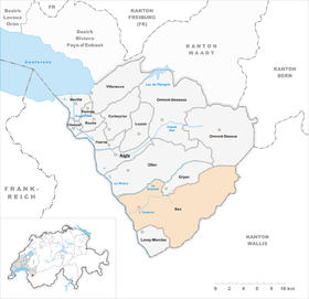
| Location of the municipality | |
  |
|
Bex [ be ] is a municipality in the district of Aigle in the canton of Vaud in Switzerland . The former German name Beis is no longer used today.
geography
Bex is 424 m above sea level. M. , 8 km south-southeast of the district capital Aigle (air line). The former street-line village extends on the eastern edge of the lower Rhône valley, on the alluvial plain that the Avançon river accumulated over time when it exited the Rhone valley, at the southern foot of the Montet forest and vineyard in the Vaud Alps .
The 96.6 km² municipal area covers a section of the lower Rhône valley and the adjacent Alps. The western part of the municipality lies in the Rhône Valley, with the canalized course of the Rhone forming the western border. To the east of the Rhône is a wide valley plain, which in turn is bounded by the hills Le Montet ( 688 m above sea level ) and Chiètres ( 608 m above sea level ). Between these two hilly areas lies the Bex basin, through which the Avançon flows. In the far south the area extends to the narrow point of the Rhône at Saint-Maurice.
The much larger eastern part of the municipality is located in the high relief area of the Vaudois Alps and largely includes the catchment area of the Avançon with its two source streams Avançon de Nant (in the south) and Avançon d'Anzeindaz (in the north). The rocky ridge L'Argentine ( 2422 m above sea level ), made of Schrattenkalk , is located between the valleys of these streams . In the southeast, the border runs over the Dent de Morcles ( 2969 m above sea level ), Dent Favre ( 2916 m above sea level ), Grand Muveran ( 3051 m above sea level ) and Tête, which are geologically part of the Helvetic nappes of the limestone Alps à Pierre Grept ( 2904 m above sea level ). The streams on the northwest flank of this mountain range are fed by several small firn fields (Glacier des Martinets, Plan Névé and Glacier de Paneirosse). In the far east of the municipality of Bex lie the extensive Anzeindaz Alp and the Pas de Cheville mountain pass ( 2038 m above sea level ), which connects the Avançon valley to the Lac de Derborence . On the Sommet des Diablerets to the north of this pass , the summit of the massif of Les Diablerets , at 3210 m above sea level. M. reached the highest point of the municipality. In the north, the border runs partly along the Avançon, partly on the slope of Gryon and along the Gryonne torrent . In 1997, 4% of the municipal area was in settlements, 32% in forests and woodlands, 28% in agriculture and around 36% was unproductive land.
Numerous hamlets, individual farms and Alpine settlements belong to Bex, including:
- L'Allex, 427 m above sea level M. , in the hollow of Bex south of the Avançon
- Cotterd, 413 m above sea level M. , industrial estate near the train station
- Le Glarey, 435 m above sea level M. , to the east of Bex
- Le Châtel, 516 m above sea level M. , in a hollow at the northwest foot of the Dent de Morcles
- Chiètres, single farm settlement on a hill south of Bex
- Le Bévieux, 485 m above sea level M. , at the Avançon
- Les Dévens, 490 m above sea level M. , on the alluvial cone of the Gryonne
- Le Bouillet, 588 m above sea level M. , in the valley of the Gryonne
- La Forêt, 510 m above sea level M. , at the foot of the height of Gryon
- Le Chêne, 580 m above sea level M. , on the western slope of the heights of Gryon
- Fenalet, 710 m above sea level M. , on the western slope of the heights of Gryon
- Les Posses, 953 m above sea level M. , on the southern slope below Gryon
- Frenières-sur-Bex, 865 m above sea level M. , in the valley of the Avançon de Nant
- Les Plans-sur-Bex, 1095 m above sea level M. , in a basin of the Avançon de Nant
- Solalex, 1469 m above sea level M. , Alpine settlement in the Avançon d'Anzeindaz valley
- Anzeindaz , 1876 m above sea level M. , Alpine settlement in the Avançon d'Anzeindaz valley
Neighboring communities of Bex are Ollon , Gryon , Ormont-Dessus and Lavey-Morcles in the canton of Vaud and Saint-Maurice , Massongex , Monthey , Collonges , Fully , Leytron , Chamoson and Conthey in the canton of Valais .
population
With 7771 inhabitants (as of December 31, 2018), Bex is one of the larger municipalities in the canton of Vaud. 83.8% of the residents are French-speaking, 3.9% speak Albanian and 3.4% are German-speaking (as of 2000). The population of Bex was 3091 in 1850 and 4561 in 1900. Then it commuted between 4200 and 4800 residents until 1960. Since then, the population has increased again, especially during the 1980s.
economy


Bex developed thanks to the salt mines known since the 16th century, but only systematically exploited since 1680 . The total length of around 50 km shows the importance of salt mining in the lower Rhône Valley. In Sublin also was temporarily (1800) sulfur mined. Today only the Bévieux saltworks is still in operation; brine is produced for Novartis . Since the beginning of the 20th century, new businesses have settled in Bex and promoted the development of the community into an industrial center.
Today Bex offers around 2,300 jobs. With 15% of the workforce still employed in the primary sector, agriculture still has a certain place in the employment structure of the population. Around 34% of the workforce is employed in the industrial sector, while the service sector accounts for 51% of the workforce (as of 2001).
Agriculture still shows great diversity thanks to the extensive municipal area and the different altitudes. On the southern slopes of the hills of Le Montet and Chiètres as well as in the area of Le Chêne, viticulture is practiced on an area totaling over 100 hectares . In the Rhône Plain, the agricultural areas are used for arable and fruit growing , while chestnut forests thrive on the lower slopes . The higher elevations are used for dairy farming and cattle breeding . In the Alps there are extensive alpine pastures for the summer grazing of the livestock.
The industry has mainly settled in the Rhône plain near the train station. Important companies are a gypsum factory, a paper factory, metal and steel construction, mechanical engineering, construction (including sandblasting and protective cladding), a cable factory and an electroplating company. Some residents also commute to the industrial town of Monthey, which is located on the other side of the Rhône, with a petroleum refinery and chemical industry. At the Avançon there is a power station of the Forces motrices de l'Avançon.
tourism
The use of thermal springs brought about a significant economic boom in the 19th century; numerous hotels were built in Bex. After the heyday at the beginning of the 20th century, however, the hotel industry could no longer keep up with the increased expectations and needs of tourists after the First World War, and as a result experienced a slump. The Hôtel des Salines, which was founded in 1868 and opened in 1871, dates back to this early period. It had to cease operations in 1976, was placed under a preservation order and fell victim to a fire in 1981.
The main tourist attraction today is the Bex salt mine (Musée de la mine du sel). The Sentier du Sel has existed between Salin-sur-Ollon and Bex since 2008 . The municipality also has a national exhibition of contemporary sculpture (Bex et Arts) and a botanical garden in Pont-de-Nant founded in 1891.
traffic
The community is very well developed in terms of transport. It is only a little off the main road 9 , which leads from Lausanne via Sion to the Simplon Pass . The next motorway connection to the A9 (Lausanne – Sion), which opened in 1980 and crosses the municipality, is around 2 km from the town center.
On June 10, 1857, the Villeneuve -Bex section of the railway line from Lausanne to Sion was inaugurated. The continuation from Bex to Saint-Maurice has also been in operation since November 1, 1860. Bex train station is the starting point for the Bex-Gryon-Villars narrow-gauge railway to Villars-sur-Ollon .
Bus routes from Bex to Monthey , to Fenalet and to Les Plans-sur-Bex ensure the fine distribution of public transport . There has been an airfield in the Rhône plain since 1919, where an international airmen's meeting has been held every year since 1974.
history
Bex can look back on a long history of settlement. The earliest evidence of human presence is the Abri Sous Barme, in which traces from the Neolithic were found. A burial ground dates from the Bronze Age and the remains of two manors have been preserved from the Roman period . At that time, a bridge on the trade route from Aventicum (Avenches) to Octodurum (Martigny) crossed the Rhône between Bex and Massongex . Roman names of Bex were Baccae , Baccium and Bactiacum .
The first documentary mention dates back to 574 under the name Baccis villa . At that time, Franconian troops and bands of robbers of Lombard origin who had invaded Valais faced each other near Bex . Later the names Bacium , Baiz , Baz and in 1245 Bez .
The area of Bex came into being in 999 through a donation from the Kingdom of Hochburgund to the Bishop of Sion. From the 12th century it was subordinate to the Counts of Savoy in secular matters. Since that time the noble family de Baiz (or de Bex) is mentioned, whose castle was on the hill area of Chiètres south of the village. Two other castles controlled the valley of Avançon their way across the Saumpass Pas de Cheville. Since the beginning of the 14th century, the Bex rule was split up into numerous fiefs and fiefs.
As early as 1464, Bex was occupied by Bern as a result of punitive action. In 1476 the Upper Valais invaded and set the castle on fire. The community therefore placed itself under the protection of Bern and was incorporated into the Aigle governorate . As a mandement, the municipality had its own court of law. The Reformation was introduced in 1528 . After the collapse of the Ancien Régime , Bex belonged to the canton of Léman from 1798 to 1803 during the Helvetic Republic , which then became part of the canton of Vaud when the mediation constitution came into force . In 1798 it was assigned to the Aigle district. The prosperity of Bex in the 19th and early 20th centuries was closely linked to the salt mines and spa tourism of that time.
coat of arms
Description : In blue a black hoofed silver ram and an eight-pointed gold star above it.
Attractions
The Saint-Clément church, first mentioned in 1193, was rebuilt in the 15th century. As a result of a conflagration in 1813, the choir and the nave were rebuilt in the classical style, while the massive front tower with a late Gothic portal dates back to 1501. In the picturesque center of Bex are the Hôtel de Ville (town hall) from 1747 and some town houses from the 17th to 19th centuries. On the hill south of Bex stands the Tour de Duin round tower, a remnant of the 12th century castle of the Bex rulership, which was destroyed in 1476 during the Burgundian Wars . The Château Grenier was built in 1641 and underwent an extensive restoration in 1850.
photos

Old rectory
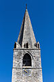
Steeple

Gym

Catholic Church

Parish hall

Rue Centrale at the market square
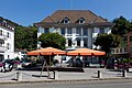
Marketplace with post office

Quai de l'Avançon

Quai de l'Avançon
Mine you bouillet


Town twinning
Bex maintains a town partnership with Tuttlingen in Baden-Württemberg. Every year there is a student exchange in the eighth grade. There has also been a partnership with Draguignan since 2007 .
Personalities
- Henri Pittier (1857–1950), naturalist
- Louis-Emil Eyer (1865–1916), sports educator, founder of the Bulgarian sports movement
- Catherine Mabillard (* 1964), ski mountaineer
Web links
- Official website of the municipality of Bex
- François Berger: Bex (municipality). In: Historical Lexicon of Switzerland .
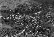
- Aerial views of the village
- Musée historique du Chablais
- Bex Salt Mine website (German)
- Le sentier du sel
- Belle Époque revisited - on the trail of the Grand Hôtel des Salines
Individual evidence
- ↑ Permanent and non-permanent resident population by year, canton, district, municipality, population type and gender (permanent resident population). In: bfs. admin.ch . Federal Statistical Office (FSO), August 31, 2019, accessed on December 22, 2019 .
- ↑ Demandeurs d'emploi, chômeurs et taux de chômage par commune. ( XLS , 115 kB) Statistique Vaud, Département des finances et des relations extérieures (Statistics Vaud, Department of Finance and Foreign Affairs), accessed on June 14, 2015 (French).
Aigle | Bex | Chessel | Corbeyrier | Gryon | Lavey-Morcles | Leysin | Noville | Ollon | Ormont lingerie | Ormont-Dessus | Rennaz | Roche (VD) | Villeneuve (VD) | Yvorne
Former parishes: Lavey | Morcles
Canton of Vaud | Districts of the canton of Vaud | Municipalities of the canton of Vaud