Geography of Cuba
Part of the West Indies
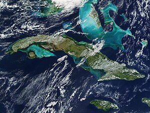
The island nation of Cuba is part of the Greater Antilles . The territory covers, including Isla de la Juventud (also called Isla de Pinos ) and over a thousand small islands on the Cuban shelf , a total area of 109,884 km². The main island of the same name is the largest of the over 1,000 West Indian and Caribbean islands, which include the Greater Antilles , the Lesser Antilles and the Bahamas . This chain of islands connects the two continental blocks of North and South America and, taking into account the relief of the sea floor, forms one of the largest mountain ranges on earth. The maximum difference in altitude between the highest point of the West Indies, the Pico Duarte on Hispaniola (3175 m), and the deepest point of the deep-sea trenches near the islands (distance from the coast often only 30 km) is approx. 12,500 m.
Geographical location
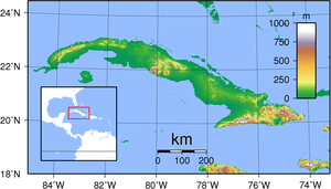
Cuba is located a little south of the tropic between 23 ° 17 'and 19 ° 49' north latitude ( Havana is at a similar latitude to Aswan or Calcutta ) and between 74 ° and 85 ° west longitude . With the exception of the northwest, which borders the Gulf of Mexico , most of the north coast of the main island is on the Atlantic Ocean , the entire south coast is on the Caribbean Sea . The distance to the neighboring Antilles islands of Hispaniola and Jamaica is 77 km and 140 km, respectively. The closest distance to the American mainland is 180 km ( Florida , it is only 140 km to Key West , the southernmost island of the offshore Florida Keys ), 210 km from Cuba's westernmost point is the Yucatán Peninsula, which belongs to Mexico .
Coasts and waters
On Cuba's main island, large areas of the north coast are rocky cliffs, as the island has been rising up out of the sea for millions of years due to tectonic processes . The south coast is rather flat; Sandy beaches, mangrove forests and, above all, the marshes of the Zapata Peninsula , shallow wetlands similar to the Everglades, extend in their course .
The Isla de la Juventud , 50 km from Cuba and the largest of Cuba's secondary islands, has distinct stretches of beach on its coasts, some of which are made of black sand due to their volcanic origin.
There are over 200 rivers in Cuba, none of which are longer than 250 kilometers and since the heavy deforestation and monocultures in large areas of the plains hardly carry any water. The most important rivers of Cuba are: Río Cauto (which was navigable for the first decades after the settlement by the Europeans and is now a sluggish, shallow, hardly flowing body of water), Río Salado, Río Hanábana, Río Caonao, Río Jatibonico del Sur, Río Cojímar. Nowadays, many bodies of water are often affected by heavy pollution or weed growth - the Río Cojímar is now an open sewer in Havana, others, such as the Río Toa, have almost drinking water quality.
Geographical breakdown
General
While the other large islands of the Greater Antilles have a decidedly mountainous character, the surface appearance of Cuba's main island, apart from four larger mountain ranges, is characterized by extensive plains. With an east-west extension of around 1250 km, the distance between the north and south coast varies between 32 and 145 km. In addition, three-quarters of the territory are plains with altitudes between 0 and about 100 meters. These flat landscapes appear very monotonous. If sedimentary rock, as an existing rock, resulted in the formation of good soils, sugar cane is usually grown over a large area . With serpentine as an adjacent rock, sterile soils developed that only allow extensive pasture use . Pastures have been overgrown with the " Marabú " ( Dichrostachys cinerea ) introduced from Africa for several decades .
The highest mountains are located in eastern Cuba in the Sierra Maestra , with the highest point on the island, the 1974 meter high Pico Turquino . To the northeast of it is the Sagua-Baracoa massif . The Escambray and the Sancti-Spiritus mountains rise in central Cuba . The Guaniguanico massif extends in western Cuba .
Eastern Cuba
Eastern Cuba is mountainous. The highest mountains are in the east of Cuba in the Sierra Maestra , with the highest point on the island, the 1974 m high Pico Turquino . Other high mountains are: Pico Cuba (1872 m), Pico Suecia (1730 m), Pico Bayamesa (1730 m), Pico Martí (1722 m), Pico Maceo (1720 m), La Gran Piedra (1214 m) or the Pico Cristal (1214 m) in the Sierra Cristal . Further to the northeast is the Sagua-Baracoa massif , in the local biosphere reserve Cuchillas de Toa, Cuba's most water-rich, 130 km long river, the Río Toa, has its source . There is a tropical rainforest north of the mountain range. The coastal strip south of the mountains and east of Guantánamo Bay is the driest region in Cuba. Large parts of this area are under national protection with the Reserva Ecológica Baitiquirí and the Reserva Ecológica Tacre. The Hatibonico-Baitiquirí-Imías area is internationally recognized as an important bird sanctuary. Further to the east, extensive marine terraces characterize the coastal landscape of the Maisí municipality .
Central Cuba
The Escambray and the Sancti-Spiritus mountains rise in central Cuba . But in central Cuba the landscape is dominated by wide plains. These plains have been completely deforested and are mainly used for sugar cane production.
Western cuba
Western Cuba roughly corresponds to the province of Pinar del Río . The most important landscape is the mountain range. The Guaniguanico massif is divided into two mountain ranges - the Sierra del Rosario and the Sierra de los Organos . The Sierra del Rosario is geologically very diverse, with rocks of different compositions and times of origin. The first chain mentioned has a more variable relief than the second, with the highest elevation in western Cuba, the Pan de Guajaibón (692 m).

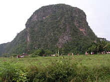
In the Sierra de los Organos you can roughly see three relief levels, flat areas with altitudes between 100 and 130 meters, the hills of the Pizarras , which have been eroded to different degrees, and the summit areas of the Kalksierren with altitudes of 400 to 500 meters. The peak areas of the sierras are radicals of the Miocene hull surface , whose level starting exogenous forces the mogotes have worked out of the surrounding rock (Lehmann, 1960). The highest point of the "Organ Mountains" is stated by Blume and other authors to be the 591 m high Pan de Azúcar, in the latest available map (1991) the Mogote of the same name is only 335 m high. In contrast, the map contains a measuring point with 616 m in the Sierra del Infierno . (Heights given by different authors and in the maps often vary by a few percent).
If you drive from south to north through the province of Pinar del Rio you will see the following landscapes:
- In the south there are initially flat coastal areas with mangrove forests with clear zoning of the mangrove species. The zoning of vegetation depends on the distance to the sea, the resulting frequency of flooding and the resulting different levels of salt content in the soil.
- This is followed by a 10 to 25 km wide area with so-called pine woodland on white sand , the most important tree species in this area is Pinus tropicalis . The originally loose forest has been degraded by grazing . Today the vast areas cover open forms of vegetation such as pine-palm-grassland or palm- savannah .
- This is followed by a hilly landscape known as Pizarras or Lomas. The geological subsurface is the Cayetano Formation with schists and sandstones. A forest of Pinus tropicalis and Pinus caribaeae grows on it .
- This is followed by the Sierra de los Organos with its cone karst mountains and fertile valleys. The most famous valley is the Valle de Viñales .
- To the north there is another area with pizarras and palm savannah. Then a wide mangrove border forms the transition to the sea with offshore small islands ( cayos ).
Isla de la Juventud
The 3050 km² large Isla de la Juventud to the south is largely flat. Only in the northern region around the main town Nueva Gerona there are smaller mountain ranges with elevations up to 280 m. While the north with its fertile soil is used as a cultivation area for fruits, the southern part is criss-crossed by marshland and pine forests, which is why the island was officially called Isla de Pinos (German: Pine Island ) until 1978 . In addition, the island has the largest marble deposits in Cuba.
flora
The official statistics report of Cuba for the year 2015 gives 6509 flowering plants, 5844 fungi and lichens, 557 fern plants, 500 liverworts and 411 mosses. The proportion of endemic species is high, 43.2% on average, 52.5% of the species are endemic among the flowering seeds. The majority (approx. 60%) of the area of Cuba is used for agriculture. Dominating the cultivation of sugar cane and plantations of tobacco , bananas , oranges , cocoa or coffee . The forest consists of coniferous forests in arid areas, the Cuban wet forests and mangrove forests . Particularly dry areas around Guantanamo have vegetation with cactus plants .
fauna
Many animal species in Cuba are considered endemic , such as the bee elf or Cuba's national bird, the Kubatrogon , named after its song tocororo . Other species such as tree rats can also be found on other Caribbean islands.
Endangered species include the Cuban weevil , the Monte Iberia frog (Eleutherodactylus iberia), one of the smallest amphibians in the world, and the Polymita picta . The populations of the Cuban crocodile are stable through breeding programs and consistent protection of the distribution area, the Ciénaga de Zapata . A well-known non-endangered species is the Cuban flamingo , which can be observed in lagoons in Central and South America. Animals such as zebras imported from Africa or Asia live freely on the island of Cayo Saetía .
National parks
The following national parks currently exist in Cuba: Gran Parque Nacional Sierra Maestra ; Parque Nacional Alejandro de Humboldt ; Parque Nacional Ciénaga de Zapata ; Parque Nacional de La Güira; Parque Nacional Desembarco del Granma ; Parque Nacional Viñales ; Pico cristal; Parque Nacional La Mensura; Parque National de Guanahacabibes ; Jardines de la Reina
The government repeatedly enacts laws to protect large areas in different regions of Cuba. However, the anthropogenic changes are already very far advanced in most areas and the poverty of the rural population is largely causing the well-intentioned plans to fail. Pure primary vegetation has therefore been preserved mainly in the total reserve in the northern area of the Sierra Maestra and in the "Alejandro de Humboldt" National Park ( Parque Nacional Alejandro de Humboldt , UNESCO Patrimonio de la Humanidad).
See also
Web links
Individual evidence
- ↑ http://www.protectedplanet.net/search?country=Cuba&designation=Ecological+Reserve&main=country
- ↑ http://www.snap.cu/index.php/ct-menu-item-10/ct-menu-item-13
- ↑ http://www.onei.cu/aec2016/02%20Medio%20Ambiente.pdf
- ↑ http://knoema.de/atlas/Kuba/topics/Landendung/Fl%C3%A4che/Landwirtschaftliche-Nutzfl%C3%A4che-percent-der-Gesamtfl%C3%A4che Koema.de
- ↑ [1] , accessed June 24, 2019


