
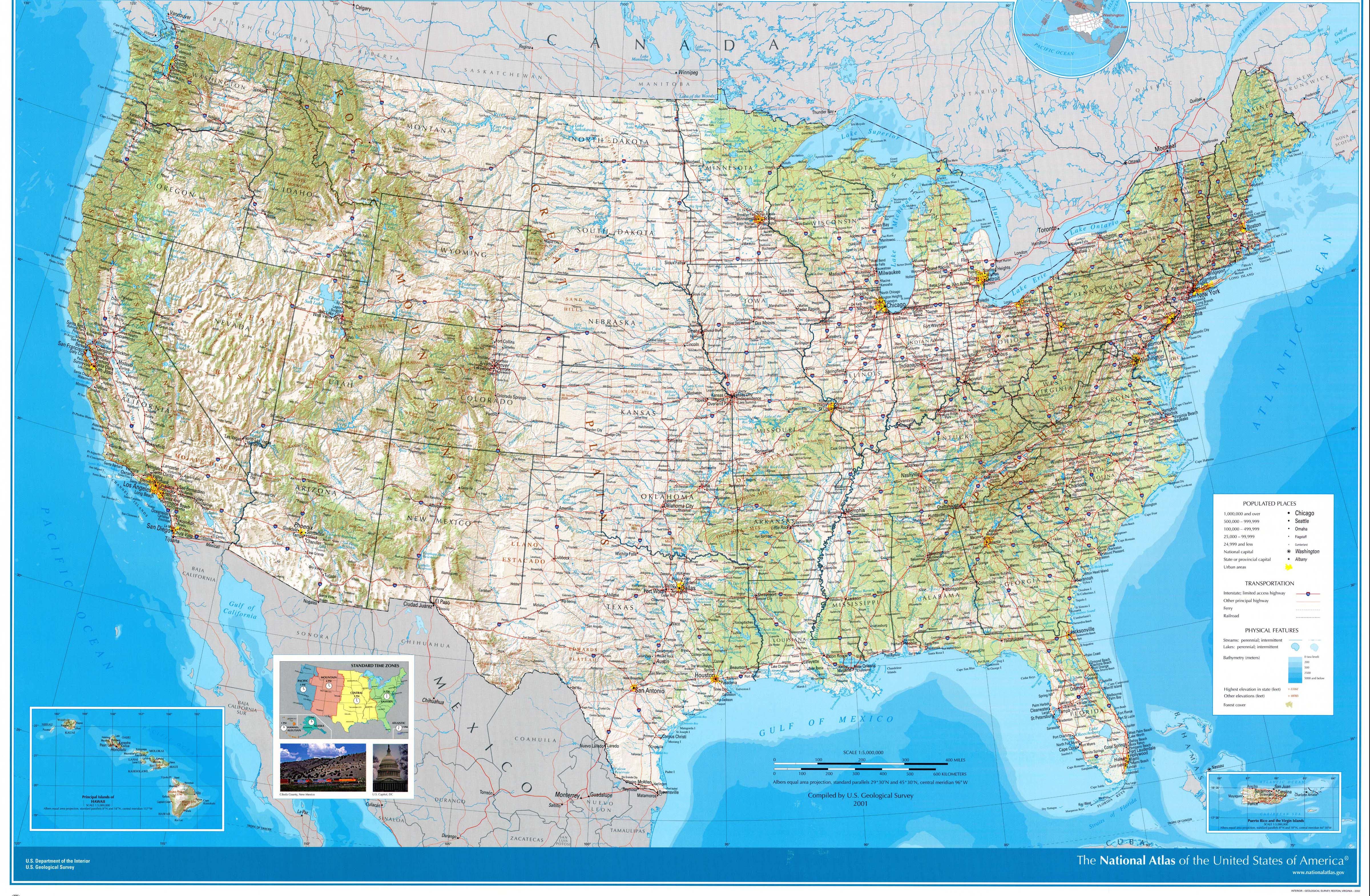
United States geography

Of the 50 US states , all except Hawaii are on the North American continent . Except for Alaska and Hawaii, the remaining 48 states and the District of Columbia lie together within a common border and form the heartland of the United States .
The landscape is very diverse: forest areas and low mountain ranges on the east coast , mangrove forests in subtropical Florida , the river systems of the Mississippi River and Missouri River , the wide plains in the center of the country, the great mountain range of the Rocky Mountains , the dry deserts in the southwest, the temperate ones Rainforests in the northwest and the coastal mountains on the west coast .
Add to this the coming Arctic region of tundra in Alaska and the tropical islands of Hawaii with the 4170 meter high volcano Mauna Loa .
Political Limits

The heartland is located between the 24th and the 49th northern latitude and between the 67th and 125th west longitude and is divided into four time zones divided. Alaska and Hawaii as well as the outer areas politically attached to the United States (for example Puerto Rico and Guam ) are outside this zone. The 49th parallel is only towered north in the Northwest Angle .
The US has political borders with Canada and Mexico . The border with Canada has a length of 8893 kilometers (of which 2477 kilometers between Alaska and Canada), the border with Mexico has a length of 3326 kilometers. The coastline is 19,924 kilometers.
The 48 contiguous states border Canada in the north and Mexico in the south. To the east lies the Atlantic Ocean and to the west the Pacific . The north-south extension is about 2500 kilometers. There is a distance of around 4500 kilometers between the Atlantic and Pacific Oceans.
Hawaii is a chain of islands in the Pacific Ocean. Alaska is northwest of Canada and is separated from Russia by the Bering Strait .
In particular, the following states have borders:
- Canadian border: Alaska, Maine, New Hampshire, Vermont, New York, Pennsylvania ( Lake Erie ), Ohio (Lake Erie), Michigan (Great Lakes), Minnesota, North Dakota, Montana, Idaho, and Washington.
- Mexico border: California, Arizona, New Mexico and Texas.
- Border with Russia: Alaska
- Borders with Cuba and the Bahamas: Florida
surface

The United States is the surface-moderately third largest state of the earth , if you count only the land area of the fourth largest since China has fewer inland waters. The country is a little smaller than Canada, half the size of Russia and 2½ times larger than Western Europe .
- Area of the 50 states (including the District of Columbia): 9,629,101 km²
- Land mass: 9,158,960 km²
- Water surface: 470,141 km²
Natural structure
The United States can be divided into several natural regions . The main regions are as follows:

Atlantic coastal plain
Along the Atlantic coast , around the Florida peninsula and on the Gulf of Mexico there is a flat plain in which there are many large cities: Boston and New York City on the Atlantic, Washington on Chesapeake Bay , and Atlanta , Miami , New Orleans and Houston in the Southern states.
In southern Florida is the tropical marshland of the Everglades and the third largest coral reef on earth. There are numerous wetlands in the Gulf of Mexico .
Appalachian highlands
Inland lies the wooded low mountain range of the Appalachian Mountains . It stretches across several mountain ranges from the Canadian border in Maine to the Great Smoky Mountains and on to Alabama in the south. The highest peak is Mount Mitchell , North Carolina , at 2040 meters .
In the Appalachian Mountains there are natural resources such as coal and ores such as iron. Here is the industrial city of Pittsburgh in the state of Pennsylvania .
Canadian shield (also Laurentian shield)

Only the Superior Upland in the Upper Lake area and the small mountain system of the Adirondacks in the northeast of New York State belong to this natural space unit within the national territory of the USA . The Adirondack Mountains in particular are often assigned to the Appalachians, although their geological structure is more similar to the Laurentine Mountains of Canada and is characterized by the archaic and Proterozoic rocks of the Canadian Shield .
The small-scale areas were nevertheless given economic importance due to their great ore wealth.
Central Plain and Highlands (also Inner Plain)
The Central Plain stretches along the Mississippi River and Missouri River from the Great Lakes in the north, through Illinois and Arkansas to the Gulf of Mexico in Louisiana . For example, the cities of Chicago and Memphis are in the region . To the west of the lowlands is a higher region that extends from North Dakota through the states of Oklahoma and Nebraska to Texas .
The Central Plains and the Highlands are partly part of the Midwest and the Great Plains . The area is characterized by prairie landscapes and large agricultural areas, but also by industrial cities and transport infrastructure (Chicago rail junction, Chicago O'Hare airport ).
Rocky mountains
The mountain range of the Rocky Mountains extends to the west over the entire North American continent in a north-south direction: Depending on the definition, they begin in Alaska or Canada and continue via Idaho , Montana , Wyoming , Colorado and New Mexico to Mexico.
The mountain range is partially 1500 km wide.
The highest point of the Rocky Mountains in the heartland of the United States is the 4,396 meter high Mount Elbert in the state of Colorado . In the area of the Rocky Mountains are the Yellowstone National Park , as well as the cities of Denver and Santa Fe .
Large pool

In the north of endorheic Great Basin (Great Basin) are wide salt flats and the Great Salt Lake in Salt Lake City . In Nevada lies the dry and cool Great Basin Desert . Further south, Las Vegas and the hot Mojave Desert , the Valley of Death (Death Valley) and the Colorado Plateau to the Grand Canyon . The Colorado River runs through the area. To the west, the Great Basin area is bounded by the Sierra Nevada .
In the valley of death, Badwater, the deepest point in North America, lies at an altitude of 85.5 meters below sea level.
Further south, the species-rich Sonoran Desert begins in Arizona with the cities of Phoenix and Tucson .
Pacific coast
The states of Alaska , Washington , Oregon and California border the Pacific from north to south .

The greater Pacific Northwest region in the United States includes the states of Oregon, Washington, and Idaho, with Idaho not bordering the Pacific .
In these states (except Idaho) is the cascade range with the 4,377 meter high Mount Rainier and the volcano Mount St. Helens . Further south, in California , the mountain range continues into the Sierra Nevada . Here is the highest mountain of the 48 contiguous states, Mount Whitney 4418 meters high . There are a number of coastal mountains along the Pacific coast .
The Pacific Northwest is mainly drained by the Columbia River . In Seattle there on the Olympic Peninsula a temperate rainforest . This is the northernmost rainforest in the world.
North of San Francisco and in the Sierra Nevada are areas with sequoias . In the states of the Pacific coast there are numerous national parks (NP) such as Yosemite-NP , Sequoia and Kings Canyon-NP and Redwood-NP (both California), the Olympic-NP , the Mount-Rainier-NP and North-Cascades-NP (each Washington) as well as the Lake-Clark-NP and Kenai-Fjords-NP (each Alaska).
climate

Climatic classification
Because of its size and variety of geographic features, the United States participates in many climates. The climate is temperate in most areas , tropical in Hawaii and southern Florida , (sub-) polar in Alaska , Mediterranean on the coast of California (including the area of Los Angeles and San Diego ) and hot and dry in the Great Basin . While the climates are zonally arranged in the east of the states, orographic influences are noticeable in the climatic structure in the west. Its relatively generous climate partly contributed to the rise of the country to world power, with less severe drought in the major agricultural areas, there is hardly any extensive flooding and a mainly temperate climate that receives adequate rainfall.
Basics of the climate
Due to its location in the middle latitudes, the USA has a predominantly (cool) temperate climate with year-round precipitation, which is followed by the warm temperate subtropical zone in the south. The size of the country and the design of the surface cause a considerable differentiation of the climatic facilities. So complicate the meridional , d. H. in a north-south direction, cordilleras, maritime air masses from the Pacific, the penetration into the interior and weaken fronts of passing cyclones , so that North America has a far more continental influence than Europe. The damming effect on the Cordilleras means that the Pacific coast receives abundant precipitation, but the intramontane basins in the lee side have extremely little precipitation and are therefore desert and semi-desert in character. The Great Plains in the lee of the Rocky Mountains are also characterized by poor rainfall .

On the other hand, the Great Plains and the Central Lowlands allow air mass exchange from north to south and vice versa. Since there are no mountains in zonal (east-west) alignment, arctic air masses can advance far into southern latitudes, but maritime, warm, humid air can still cause heat waves in the north . In the Inner Plains and Great Plains, sudden changes in weather and rapid temperature changes are therefore not uncommon. From the climatic dry line , which runs roughly along the 100th meridian, the humidity increases to the east under the influence of warm, humid air masses from the area of the Gulf of Mexico . Maritime- tropical air influences the coastal plains almost all year round and often brings about thunderstorms and downpours, in the hurricane season also violent tropical cyclones .
Important weather-effective ocean currents on the Atlantic coast are the Florida Current and, in its continuation, the Gulf Stream, which transport warm water along the Atlantic coast far to the north and thus cause higher temperatures and higher humidity . On the other hand, the Labrador Current brings polar water to the coasts of the northeastern United States and provides the New England states with plenty of cool rainy days. In the Pacific waters, the cool California Current causes cold deep water to lift up off the California coast and thus brings many days of fog to the coastal regions , but only little rain .
Pressure conditions and general weather conditions

Most of North America lies all year round in the area of the extra-tropical west wind zone, influenced by the polar front jet stream . Over both oceans there are quasi-stationary subtropical high pressure cells (North Pacific and Bermuda high ) and over more northerly waters the Aleutian Depression and the Icelandic Depression as core zones of the polar low pressure channel. In the winter months, a cold air high forms over the mainland, which, in contrast to the subtropical high pressure cells, is only close to the ground (one to two kilometers in height) and is reduced again with increasing temperatures in the summer half-year.
Weather conditions in winter
In the low pressure core over the Aleutian Islands , cyclones are formed, which, controlled by the polar front jet stream, move eastward to the North American continent. Due to the dynamic instability of this high-altitude flow and the orographic influences (north-south stretching cordillera system), the advances are hindered in such a way that the polar front jet streams strongly meander or even split into individual partial jet streams. The main route of the cyclones is the middle orbit, in which a large part of the jet stream is diverted to the north over the Cordilleras, creating a quasi-stationary Great Basin high over the western states, for example in the area of the Great Basin . In the area of influence of this high altitude wedge, warm extra-tropical air masses can penetrate far towards the poles with the west drift and, together with the warm north Pacific current, thermally favor the west sides compared to the east sides, because there cold polar air is directed south via a high trough and the north-east of the states additionally by the cold Labrador current cooled down. On the middle track, cyclones can travel southeast over the Great Plains and Inner Plains. Over the coastal plains, the cosmic ray current then changes its direction of movement along the Atlantic coast to the northeast.
If the intramontane high pressure area is more pronounced, the maritime Pacific air crosses the Cordilleras further north. This second trajectory (meridional circulation form) directs the cold air over the plains of Canada and the USA far south and causes cold air ingresses (Cold Wave or Texas Norther ), which can be associated with temperature drops of up to 25 Kelvin, freezing rain (sleet) and snowstorms ( blizzard ) . A low profile of the high trough, on the other hand, results in a strong altitude jet flow (zonal form of circulation). The high altitude then occasionally shifts to the west, so that cold but dry air masses flow into the western half of the USA, while relatively warm air masses flow in further to the east due to prevailing south-westerly currents and cyclones migrate from south-west to north-east.

In winter, depending on the course of the high-altitude currents, when the tropical-warm and polar-cold air masses meet with each other with different levels of humidity, cyclones over the continent can regenerate or form, which move from west to east across the continent following the influence of the west wind. Over the Great Lakes , the cyclones can become charged with moisture and drain it off in the form of snow on the lee bank of the lake. This lake effect snow brings, as the lakes represent a large heat and water reservoir, especially in winter, regularly increased amounts of snow (one speaks therefore of the snow belt ).
The rapidly successive cyclonic weather conditions are often replaced by anti- cyclonic conditions . Then there is dry, clear and cold, in the northern areas also icy weather. Especially in winter, the weather in the USA is very changeable and always difficult to predict because of the different meandering train tracks of the west drift.
Weather conditions in summer
While most of North America is also in the summer under the influence of extratropical westerlies, the weather process in the southwest and south of the United States (between 30 ° and 40 ° north latitude) is then of the North Pacific High and passatischen flows on the eastern flank of the Bermuda highs (North - to north-west winds). As a result of the pressure gradient between the air above the sea and the strongly warmed land masses, a monsoonal , i.e. H. northward air movement. As a result, the maritime tropical air reaches far inland and, caused by the strong warming of these unstable air masses over the continent, leads to abundant convective precipitation, which usually comes down in the form of violent thunderstorms in the afternoon (in the southeast of the USA there are 60 to 70 days with thunderstorms on an annual average ). Particularly powerful and far-reaching advances of these marine-tropical air masses can cause heat waves that last several days.

The tropical-maritime air flows inland over the coast of California because of the pressure gradient , but is cooled before it even reaches land due to the low temperatures of the California Current and its upwelling water. This is why there is regular summer fog formation in the coastal area , which, however, does not reach much inland in the valleys of the Coast Ranges , as the air over the warm and dry land warms up quickly. Occasionally, anti-cyclonic pressures move further north across the cordillera system and bring precipitation to the Pacific Northwest. In the interior of the country, a blow-dryer effect is noticeable in that the maritime Pacific air warms up considerably after having overcome the mountains and appears as a hot fall wind , especially on the eastern edge of the Rocky Mountains . During the summer, due to thermal factors, there is low pressure over the intramontaneous basin with the center in the area of the lower Colorado valley ( Yuma low ). With strong sunlight and generally very low humidity, there is great dryness and warmth.
Weather conditions in spring and autumn
Spring and autumn are the seasons of transition, the change from summer to winter weather conditions and vice versa. A special feature here is the Indian Summer , a large -scale weather situation similar to the Central European Indian Summer , which occurs in the north of the national territory in anticyclonic conditions in September and is characterized by calm, no clouds, high daytime warming and strong nighttime cooling.
Thermal and hygric conditions

A climatic division of the USA shows a distinctive dry line parallel to the 100th degree of longitude (area of the Great Plains), which divides the state into a (semi-) arid western side and a humid eastern side. In addition, the United States can roughly along the 40th parallel into a cold to cool temperate north and a warmgemäßigt - subtropical south are divided. The regions west of the dry line are more characterized by hygric seasons , east of it predominantly by thermal seasons . The isotherms (at least in the eastern half) are largely zonal (parallel to the latitude), the relief conditions lead to the formation of climatic altitudes . The annual mean temperatures decrease from about 20 ° C in Florida and the Mississippi Delta to 10 ° C, in places below 5 ° C, on the northern state border, the vegetation period from over 300 days in the south to less than 100 days in the north. The annual temperature amplitudes increase with increasing continentality and in the lee of mountain ranges. Ingress of cold or warm air with a temperature difference of up to 40 Kelvin within 24 hours is not uncommon. In the coastal plains , the Appalachian Mountains and the Inner Plains , there is a summer rainy or autumn rainy climate, which comes down through convection with unstable air layers with thunderstorms and heavy rain. In the continental and montane area, up to five nival months are possible, in the Great Plains, the Lowlands and the Great Lakes one to three nival months. On the Pacific coast there is a winter maximum of the precipitation , also in intramontane basins the precipitation maximum is in winter, then mostly in nival form.The strong north Pacific anticyclones leads to a summer precipitation minimum on the Pacific west coast , on the north Pacific coast there are one to three arid months and in California over six arid months. In the area of the intramontaneous basins and plateaus, the aridity increases to seven to eight months due to windward and leeward effects. Although 50% of the already low precipitation falls in the intramontane areas of the USA in June to September, these months are still arid or semi-arid due to the high temperatures.
Most hours of sunshine can be measured in the southwest of the states, in Arizona for example over 4000 hours per year. In the high altitudes and the northern areas frost can occur for 180 days , in the central lowlands 60 to 120 days, in the Mississippi Delta only a few days a year, only the southern tip of Florida is frost-free. In the climate-favored California Long Valley , the crops only have to survive around 20 days of frost, while in the neighboring Sierra Nevada more than 180 days of frost can be expected.
Climate extremes

- Tornadoes : Extra-tropical storm eddies that are particularly common in the USA in spring and summer. Tornadoes occur as violent eddies in dense cumulonimbus clouds that move in front of a cold front . Since there are no zonal weather divisions such as east-west striking mountains in the USA , dry, cold polar air can meet warm, humid tropical air ( cP and mT ). The enormous temperature difference between the two air masses causes strong storms and thunderstorms and finally a vortex with a funnel that gradually descends to the surface of the earth. The Midwest and Great Plains are hardest hit by tornadoes.
- Hurricanes : tropical cyclones that arise over the warm waters of the Caribbean and West Atlantic , usually between 10 ° and 20 ° north latitude. Tropical cyclones have an almost circular storm center with extremely low air pressure, the so-called eye . They first move westward, but are eventually caught by the west drift and deflected to the northeast, where they quickly degrade due to a lack of heat and moisture supplies. The hurricane season in the North Atlantic is from May to November, with the greatest accumulation in late summer and early autumn. Hurricanes are sometimes accompanied by a storm surge, a sudden rise in water levels. The Galveston hurricane of 1900 is legendary, when the entire city was flooded and 6000 people drowned in the hurricane wave. During Hurricane Katrina 2005, the tropical storm also pushed a flood mountain in front of it, which stood 10 m above sea level above the mainland. Hurricanes can reach wind speeds of over 200 kilometers per hour and are often accompanied by strong thunderstorms and downpours.

- Cold Waves: Winter cold snaps that cause a temperature drop of up to 25 Kelvin within a few hours. In the absence of weather divisions, polar cold air can advance far south. In the southern states, the so-called Norther can cause severe damage to crops and livestock with freezing cold, high wind speeds, snowfall or freezing rain (sleet). In the northern USA and Canada, such cold air inrushes are usually associated with snowstorms, the blizzards .
- Chinook : Foehn-like, dry and warm fall wind in the area of the extra-tropical west drift , which often occurs in the lee of the Rocky Mountains in the winter months. The Chinook brings a temperature increase of up to 20 Kelvin within a few minutes to hours and quickly thaws the thin snow cover on the plains.
- Santa Ana winds : dry and warm winds blowing from the continent to California in late autumn and winter, which are intensified by the effects of a blow-dryer. Their high temperatures and many consecutive rainless days cause and encourage many severe forest fires in California.
Climate diagrams
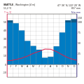
Seattle, Washington

Bismarck, North Dakota

Detroit, Michigan

St. Louis, Missouri
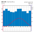
New York City, New York
Los Angeles, California

Salt Lake City, Utah

Phoenix, Arizona
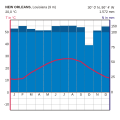
New Orleans, Louisiana

Key West, Florida


Water balance
Electricity systems (rivers)


The national territory is divided into four drainage systems : the Atlantic, the Gulf of Mexico, the Pacific and the Arctic. The Atlantic drainage system is relatively small. Numerous short rivers, including the Hudson and the water-rich Susquehanna , come from the Appalachians towards the Atlantic . The Great Lakes , which are drained by the Saint Lawrence River , are also part of the Atlantic system. The drainage system of the Gulf, which takes up almost half of the contiguous national territory, is much larger. With 3.2 million km² the catchment area of the Mississippi-Missouri is the largest river basin on the North American continent. In addition, the Mississippi, with the Missouri flowing into it, is one of the longest rivers on earth with a length of 6420 km. The Rio Grande (del Norte) with a catchment area of 570,000 km² is also part of the golf-oriented drainage system.
The watershed to the Pacific drainage system, as "Continental Divide" ( Continental Divide hereinafter) extends generally in the Rocky Mountains , but engages in part also into the intramontane areas. The most important rivers flowing into the Pacific are the Columbia and the Colorado . Most of Alaska is drained into the Bering Sea through the Yukon . The runoff of the coastal area in the extreme north feeds the Arctic Ocean , here the Mackenzie is the largest river. The large basin in the intramontaneous area is a drainless basin, the water flows endorheically in the basin and forms still waters with sometimes high salinity .
The amount of annual runoff varies greatly depending on the climatic conditions. In the humid east it is below 500 mm in places, it exceeds 1000 mm in the southern Appalachians and Adirondacks . In the western part of the national territory, the Pacific Northwest has the highest discharge values of more than 2000 mm. In the Great Plains and in the intramontaneous area, on the other hand, the discharge sinks below 5 mm in places, and some subspaces, especially the Great Basin , have no discharge. In the east all rivers are perennial , while some watercourses in the west only carry water periodically or episodically . The large rivers in the arid regions are foreigner rivers that start in the Cordilleras .
| flow | Length (in km) |
Discharge (in m³ / s) |
Catchment area (in km²) |
Mouth in |
|---|---|---|---|---|
| Arkansas | 2364 | 1161 | 416,988 | Mississippi |
| Brazos | 2060 | - | 118.103 | Gulf of Mexico |
| Colorado | 2334 | - | 637.137 | Pacific |
| Columbia | 2010 | 7504 | 668.217 | Pacific |
| Kuskokwim | 1165 | 1897 | 124.319 | Pacific |
| Mississippi | 3778 | 18,000 | 2,978,486 | Gulf of Mexico |
| Missouri | 4088 | 2158 | 1.370.104 | Mississippi |
| Ohio | 1579 | 7957 | 490.570 | Mississippi |
| plate | 1593 | - | 219,890 | Missouri |
| Red River | 2076 | 1586 | 241,387 | Mississippi |
| Rio Grande | 3058 | - | 870.236 | Gulf of Mexico |
| Saint Lawrence | 1197 | 9854 | 1,025,635 | Atlantic |
| Susquehanna | 719 | 1082 | 70,448 | Atlantic |
| Tennessee | 1426 | 1926 | 105.931 | Ohio |
| Yukon | 3187 | 6371 | 849,516 | Pacific |
Runoff is greatest on the Pacific coast in winter, in the southern parts of the Intermontane Area and in Florida in summer, and in the plains and interior plains in early summer. In all rivers that have their source in mountains, floods caused by melting snow occur in spring. The receiving waters of the tributaries have more even water flow than their tributaries. For example, water fluctuations in the Mississippi are less than in its tributaries. The St. Lawrence River has particularly balanced discharge all year round because its water flow is regulated by the natural reservoir of the Great Lakes .
The expansion of the electricity systems is well advanced. Numerous reservoirs exist in both the eastern humid and western drier areas. The resultant regulation of runoff has enabled inland shipping on tributaries of the Mississippi to begin. Of the tributaries of the Mississippi, the Missouri, Tennessee and Ohio play a role in inland shipping . The latter received a channel connection to the back in the 19th century Lake Erie , the Mississippi is on the Illinois Waterway to the Lake Michigan connected. This means that there is a continuous inland waterway route from the Great Lakes to the Gulf of Mexico . The New York State Barge Canal also connects Lake Erie and the Hudson River . The Sankt-Lorenz-Seeweg was completed in 1959, so that the Great Lakes can be reached via the Sankt-Lorenz-Strom for ocean-going shipping . The USA's waterway network is 17,700 km with 192 locks - 18% of the cargo volume is transported via waterways .
Inland lakes

The lakes wealth of the United States is substantial and can be explained by different geological , geomorphological and climatic conditions. The spit coast on the Atlantic and the Gulf of Mexico is not only characterized by lagoon , but also by beach lakes. The numerous lakes in Florida are flooded karst caves . There are also many, all small lakes in the Cordilleras . In the arid area of the Intermontane area, salty end lakes form in the Great Basin , of which the Great Salt Lake and the Salton Sea are the most important. Some lakes only appear as salt flats outside of the precipitation season . In this area, some lakes are remnants of much more extensive Pleistocene lakes; The Great Salt Lake , Utah Lake and Sevier Lake are small relics of the Pluvial- Pleistocene Lake Bonneville .
The area of the Pleistocene glaciation is particularly rich in lakes . Countless lakes can be found in the Adirondack Mountains , the Northern Appalachian Plateau and around the Great Lakes in Wisconsin and Minnesota , the latter state is even called the " Land of ten thousand lakes ". The five Great Lakes themselves also go back to the Pleistocene glaciation; meltwater filled tectonic hollows to form glacial lakes. With 246,480 km² the Great Lakes are the largest contiguous freshwater area on earth, the Upper Lake is the second largest lake after the Caspian Sea . They have brisk shipping traffic and are known as the inland ocean of the USA because of their importance for the transportation of raw materials. Like many other lakes, the Great Lakes are valued tourist and recreational areas .
In addition to natural lakes, there are over 8,000 reservoirs in the United States . In terms of area, Lake Powell in Utah or Arizona is the largest artificial lake. It was created in the 1960s by damming the Colorado on the east side of the Grand Canyon . The Hoover Dam, on the other hand, accumulates the largest volume of water . Since 1936, the water of the Colorado has been gathering downstream of the Grand Canyon to form Lake Mead , which comprises 35 billion m³ and is still a popular destination and an important supplier of electricity for the people of California , Arizona and Nevada .
Coastal waters


On the Atlantic coast there are half-day tides with a tidal range that is 3–3.60 m in New England, 1.20–1.50 m on the central Atlantic and 0.60–0.90 m in Florida. On the other hand, on the Pacific coast and predominantly also on the Gulf of Mexico, mixed half-day tides with a lower tidal range of 1.80–2.10 m in the Pacific and 0.60–0.90 m in the Gulf occur. One consequence of the low tidal range in the Gulf of Mexico is the formation of the Mississippi Delta . Every day more than 1 million t of river cargo is poured into a bird's foot delta, which is currently growing into the Gulf over five river arms.
While New England's coastal waters are 2–3 ° C in winter and 16–19 ° C in summer, water temperatures on the southern Atlantic coast and the Gulf Coast can range between 17 and 23 ° C in winter and 27 to 29 ° C in summer ° C rise. The cool water temperatures on the northern Atlantic coast can be attributed to the Labrador Current. In the south, the warm Florida current coming from the Gulf and, in its continuation, the Gulf Stream cause the high water temperatures. The transition area between water influenced by cold and warm currents is very narrow. The Pacific coastal waters are cooler in the same latitude, the water temperatures increase in winter from 9 ° C on the Juan de Fuca Strait to 16 ° C on the Mexican border. In summer, the temperature along the Pacific coast is around 14 ° C, only in southern California the water temperatures reach 19 ° C. The cold, south-facing California Current and cold upwelling water that comes to the surface in eddies make themselves felt. In winter, the warm Davidson Current switches between the coast and the California Current , moving northward to a maximum of 40 ° north latitude and influencing the coast with warm surface water.
While the currents on the Pacific coast reach speeds of up to 0.4 knots , the currents in the Atlantic and the Gulf are 0.7–1.1 knots. The movement of the Florida Current can even reach top speeds of 3 knots. The strong currents cause a significant beach offset along the coast and are the cause of the formation of the entire Haff - Spit coast .
Both the Atlantic and Pacific coastal waters are characterized by great abundance of fish. In addition to fishing , coastal and sea shipping were also traditional forms of use. There is also an ever increasing amount of recreation and tourism , which, through sport fishing, scuba diving, sailing, water skiing, etc., is pushing the coastal areas more and more into the sphere of influence and action of people. The coastal waters also play a role as suppliers of raw materials, such as in the production of sodium chloride and potassium chloride for the chemical industry . In addition, modern technology has made it possible to exploit the raw materials in the shelf area , so that oil and sulfur are extracted in the coastal waters of Southern California and in the Gulf of Mexico . In places, the coastal waters of the USA suffer severely from intensive mass tourism, structural remodeling of the coasts, sewage discharge and the dumping of industrial waste products. The oil spill as a result of the " Ixtoc I " oil exploration accident in 1979 and the oil spill in the Gulf of Mexico caused by the sinking of the Deepwater Horizon drilling platform in 2010 are two catastrophic examples of the enormous ecological damage to natural coastal waters.
Ecoregions

Potential natural vegetation
The humid east is characterized by woodlands , which are divided zonally according to the climatic conditions . To the west determine approximately from 95 ° W long grass prairies , from 100 degrees west longitude, short grass prairies of the landscape. In contrast to those in the east, the forest lands of the west are more interspersed with conifers and are also restricted to mountain areas. The drought characterizes the vegetation in the western half, which ranges from grasslands in the dry steppes to wooded and succulent landscapes to deserts . In the Pacific coastal area, coniferous forests dominate, in California, in addition to the mixed forests, there are sub-tropical hard-leaved plants , the chaparral . The USA can be assigned to the floral kingdom of the Holarctic .
Forests in the east


The north-east is occupied by boreal coniferous forests, in which balsam firs ( Abies balsamea ), black spruces ( Picea mariana ) and in the Great Lakes area also white spruces ( Picea glauca ) occur. Small-leaved deciduous trees such as birch ( Betula ), alder ( Alnus ) and aspens ( Populus tremola ) are provided on former burn areas, in floodplains and swamp areas . Only they can thrive with a vegetation period of less than 120 days and mean daily temperatures of less than 10 ° C. The conifers have adapted through their leaf shape ( xeromorphic needles ), narrow crowns that reduce the risk of snow breakage, and columnar growth forms that allow light to be used even when the sun is low. The annual growth rate is low, but the conifers can live up to 400 years. The heather ( Calluna vulgaris ) is added to the herb layer in clear places . The coniferous forest, which is relatively poor in species, is also interspersed with swamps , raised bogs and natural meadows in places that are moist all year round . The mean annual production of phytomass is 5.5 t / ha.
The coniferous forest is followed by a transition area of mixed forests ( "Northern hardwoods" ), which is made up of maple ( Acer ), birch ( Betula ), beech ( Fagus ), spruce ( Picea ), white pine ( Pinus strobus ) and hemlock ( Tsuga ) is. Edaphic influences are noticeable insofar as the coniferous forests grow increasingly on acidic, sandy and dry substrates , while the deciduous trees prefer nutrient-rich, loamy-calcareous substrates.
The deciduous deciduous forests of the nemoral zone that adjoin to the south have a vegetation period (daily mean ≥ 10 ° C) of at least 120–180 days, not too long winter frosts and sufficient rainfall during the vegetation period. The individual forest types are arranged in a meridional manner and can be differentiated from east to west as follows: the oak forests ( Quercus ) of the Appalachians ; the mixed mesophytic deciduous forests with horse chestnuts ( Aesculus ), oaks ( Quercus ), linden ( Tillia ) and the tulip tree ( Liviodendron tulpifera ); the beech-maple forests in shady areas; the oak hickory forests ( Quercus-Carya ) in the west. In contrast to the European deciduous deciduous forests, the American deciduous forests are exceptionally rich in species as relics of the pre -cold-age flora of the Pliocene , since refugial areas were still preserved during the ice ages due to the north-south stretching mountains . The autumn colors of the Indian Summer are an expression of this biodiversity. The deciduous forests consist of 1–2 tree layers , a shrub and herb layer . Mosses are usually absent, as they are usually covered by fallen leaves . The shedding of leaves is to be understood as a protective measure against cold stress and frost dryness of the North American cold waves . The annual aboveground wood production in these forests is around 8 t / ha, the primary production including the herbaceous layer around 9.5 t / ha.
In the subtropical south-east of the USA, deciduous deciduous forests are characteristic in the interior of the country; in the Gulf Coast Plain , in north Florida and on the coasts of Georgia and South Carolina , these change into subtropical wet forests (with magnolias ) and south-eastern pine - oak forests. The flood levels ( Flats ) Altwasser -Waldsümpfe ( Hammocks ) and lagoons ( Everglades ) of the Mississippi level of hardwoods and tornado resistant Sumpfzypressen ( distichum Taxodium taken). In tropical southern Florida, epiphyte-rich , relatively large-leaved, evergreen deciduous forests thrive with tropical tree species such as evergreen oaks, magnolias and palm trees . In addition, there are swamp forests, swamp meadows and mangroves on the coasts and show the penetration of tropical and extra-tropical elements.
Grasslands (prairie)

Transitional character between forest communities in the east and prairies in the west, the meridional forest-steppe strip with local changes between oak- hickory groves and prairie has a park-like character ( “Parkland Belt” ). The forest occupies the depressions and river valleys with favorable soil and groundwater ratios. Big Bluestem ( Andropogon gerardii ) dominates the tall grasses .
Long grasses determine the appearance of the natural vegetation from about 95 ° west longitude. The American prairie differs from the European steppes in that tropical grass clans of southern origin, which bloom late in summer (e.g. Andropogon species), appear next to the other clans that bloom in early summer. Depending on the soil moisture, the prairie on plateaus (with 30–40 cm high leaves and 50–100 cm high inflorescences ), the low prairie (with 50–100 cm high leaves and 150–200 cm high inflorescences) and in the prairie of the wet Differentiate between depressions and river valleys (with leaves over 2 m high and inflorescences up to 3 m). Typical representatives of the long grass prairie are almost exclusively cryptophytes or hemicryptophytes , including bearded grass ( Andropogon scoparius ), American feather grass ( Stipa sparta ) and perennials such as the yarrow ( Achillea ), the sunflower ( Helianthus ), the goldenrod ( Solidago ) and the aster ( aster ). It is also rich in herbs .
.jpg)
With decreasing soil moisture, the mixed grass prairie connects to the west, which merges into the short grass prairie from 100 ° west longitude. Because of the drought, the grasses grow lower and often do not form a closed scar . Grasses and herbs die as early as June, leaving only 60 days for growth. In the short grass prairie there are hard grasses such as buffalo grass ( Bouteloua gracilis ) and Indian millet ( Buchloe dactyloides ). There are only a few herbs left, occasionally hardy opuntia appear as representatives of the cactus vegetation of the adjacent semi-desert. The net production in the short grass prairie is around 2 t / ha annually (stand approx. 65 cm high), in the mixed grass steppe 3 t / ha and in the long grass steppe (stand over 160 cm high) 5 t / ha. However, the aboveground phytomass in the prairie fluctuates between approx. 4500 to 6250 kg / ha in wet and 700 to 2500 kg / ha in dry years.
Between 40 ° north latitude and the Canadian state border, the belt of the long grass prairie is wider. Spring grasses such as needle grass are added to the herbaceous bluestem prairie . The short-grass prairie at their Missouriplateau one of the Great Plains, which in the east of couch grass as imported from Asia Wheat grass ( Agropyron ,) in the west of low Gramagras ( Bouteloua is covered). In the south, the prairies of the subtropical, summer-humid climate are set in shrub savannas , e.g. B. the Mesquite Savannah. The southern prairies are special in that they contain mixed grassland and woody formations. The bearded grass ( Andropogon ), the millet ( Setaria ), the thorny mesquite tree ( Prosopis glandulosa ) and acacias are typically found here. From the Mexican border to the mouth of the Mississippi, the coast is accompanied by a belt of marshland with silt grass ( Spartina alterniflora ) and further inland a prairie belt with coastal prairie grass ( Schizachyrium littorale ).
Forests to the west


In the western national territory, the forest areas are almost entirely coniferous forests and essentially limited to the mountain elevations, which, however, consist of a large number of coniferous forest types due to the large north-south extension of the mountains. First, a distinction can be made between wet and dry forests, whereby the dense wet-coniferous forests are limited to the Pacific Northwest . These tall forests, which are up to 1000 years old, are among the economically most valuable trees in North America. In the northern part, hemlock ( Tsuga heterophylla ), sitka spruce ( Picea sitchensis ), Douglas fir ( Pseudotsuga taxifolia ), arborvitae (thuja) and the Nootka cypress ( Chamaecyparis nootkaensis ) dominate. In their original state, the populations of these coniferous forests are characterized by a rich undergrowth of evergreen hardwoods and ferns . Further to the south, the vegetation of the northern California coastal strip and the mountains (in the Sierra Nevada from 900 to 2000 m) is formed by coniferous forests of redwood ( Sequoia sempervirens ), Douglas fir, fir , spruce and pine . The giant sequoia trees ( Sequoia gigantea ), which can reach a height of over 120 m, a trunk diameter of 11 m and an age of 500 to 3000 years, are remarkable .
Inland, on the eastern slope of the Cascade Mountains , the dry coniferous forest formations set in in the area with less precipitation. In the north occur in the middle layers of the clear, uniform from Pinus ponderosa formed yellow pine forests , woods and Douglas fir White pine forests to prevail at higher altitudes montane coniferous forests with fir and the high-growing lean before Engelmann spruce. In the middle elevations of the southern Rocky Mountains, dry coniferous forests are found, in which yellow pines and Douglas firs are associated, in higher elevations pine and spruce forests. For dry coniferous forests, the upper tree line , the altitude limit (Cold Timber Line), is 45 ° north at an altitude of 3000 m. There is also a lower tree line, the dry timber line, at an altitude of 1500 m. Also noteworthy is the pine tree , which is favored by fire and, as a pioneer tree , conquers the area freed from competitors after forest fires . The cones , which are sealed with resin in many trees, are of great importance for colonization , as these only open when exposed to heat and release the seeds .
Woods and (semi) deserts
The eumediterranean areas in the southern Coast Ranges and in the Californian long valley are characterized by hard deciduous trees of the chaparral (Spanish: “bush-shaped, evergreen oak”), a natural vegetation in contrast to the European maquis . Evergreen woody plants are developed as low trees or shrubs. The leaves are small, often narrow or needle-shaped, and xeromorphic . The roots have to penetrate deep into the soil, which dries out on the surface in summer. The plant tries to limit its transpiration by secreting aromatic substances or hair on the leaves . Characteristic is the large number of mostly evergreen and 1.50–2 m high shrub species, such as. B. bush-shaped oaks ( Quercus dumosa ), the strawberry trees ( Arbutus ) or shrub-like rose plants ( Adenostoma ), shrub- shaped poppies ( Dendromecon ) and herbaceous yucca species. The plants of the chaparral are adapted to intermittent fires thanks to their thick bark and quickly germinating seeds. Trees are missing due to the low annual rainfall of less than 500 mm.


Despite the predominance of dry climates, the intramontane basins and plateaus show a strong differentiation in their vegetation cover depending on width, relief and exposure. Semi-desert vegetation predominates, only the higher mountains are forested on their windward side . The Sagebrush steppe is most widespread north of latitude 37 ° north. The Sagebrush ( Sagebrush or Artemisia tridentata ) is a 1.20 to 1.50 m high shrub with a long taproot and soft, hairy and aromatic smelling leaves. It preferably occupies deeper parts of the relief ( playas and depressions) with clay-rich soils. Lower pine stands ( Pinus edulis ) and tree-shaped juniper species ( Juniperus ), the so-called pinyon stage, thrive on elevations with stony soils .
South of 37 °, the sagebrush is replaced by the creosote bush semi-desert ( Larrea tridentata or "Greasewood" ), which dominates large parts of the Great Basin . The proportion of succulents in vegetation increases southwards. The semi-desert turns into dry deserts in the Valley of Death , the Mojave Desert or the Sonora Desert . Here, the small shrub occur White Bursage ( Ambrosia dumosa ), the Paloverdestrauch that Yucca brevifolia ( "Joshua Tree" ) and cylindrical or flat Opuntias on. The woody formations in the southwest of the USA get their characteristic shape from the cacti such as the columnar, up to 10 m high saguaro cactus ( Carnegiea gigantea ). The Ruthenian brine ( Salsola tragus or "Tumbleweed" ) became famous through western films by scrolling through the picture as a symbol of silence, loneliness and despair. This steppe roller uses the wind to spread its seeds ( Chamaechorie ), but almost the entire dried out plant can be taken away by the wind. When rolling, the seeds are distributed on the ground and in a damp place the plant can sprout again. The halomorphic soils are occupied by halophytes and halophilic grasses, the most saline soils of the salt plains , especially in the area around the Great Salt Lake , completely without vegetation.
Real vegetation
Under anthropogenic influences, the actual vegetation differs considerably from the potential natural vegetation. The boreal forests and tundra in Alaska have so far been little influenced . In the mat region above the tree line and in the woodlands of the intermontane area, the changes caused by humans are rather minor. In contrast, forests in the United States have been considerably reduced by extensive deforestation , altered by predatory farming in the past, and forestry in the present.
As early as the pre-Columbian phase, some areas of the eastern forests fell victim to Indian agriculture and wood procurement. Woodland was deliberately burned down for hunting in the border to the prairie. In addition, the aborigines influenced the floral composition by favoring edible, fruit-bearing species. The European settlers also used the slash and burn method to gain arable land. However, the extent of this was still small compared to the overexploitation , which was ruthlessly pursued in the forests during the high industrialization at the end of the 19th century. The deciduous and mixed forests of North America, apart from steep mountain areas and small remaining islands, have been almost completely displaced by agricultural, industrial or other areas of use. For example, in the boreal pine forests west of the Great Lakes, large areas were cleared and the remains of wood were removed by fire. Sometimes the forest fires got completely out of control and destroyed huge areas of forest. The "Great Fire" of 1910 caused such smoke to develop from 19 to 25 August 1910 that artificial lighting was necessary during the day from the northern Intermontane area to the St. Lawrence Valley. These "Dark Days" were not isolated occurrences.

Lightning strikes are a frequent cause of forest fires , especially in the dry coniferous forests in the Cordilleras area . The more fire-resistant Douglas fir as well as the rotary pine with their cones that open after extreme heat could therefore expand at the expense of the fir-spruce forests. To this day, large areas of forest are still affected by fires caused by lightning strikes, negligence or arson. The areas devastated by deforestation and fire were partially reforested as secondary forests and their floristic composition was greatly changed. In many other cases, however, the areas are no longer capable of reforestation and are covered by bracken thickets ( pteridium in the so-called "brackish grassland" ). Modern forestry , which plays an important role in the Pacific Northwest and Southeast in particular, has a decisive influence on the composition and physiognomy of forests through its preference for certain tree species. The forests of the tree farms of large timber companies in the northwest represent a new landscape element.

The long grass prairie was turned into a mixed grass prairie through grazing and this in turn was degraded to a short grass prairie or completely disappeared through arable farming. Although the dampness of the soil would certainly allow foresting of the prairie, the forest cannot gain a foothold in the area of the long grass prairie either. Because of the intensive grazing by huge bison herds and natural and artificial fires, grass growth was always encouraged. The competition of young trees and grasses for both light and water as well as periodically occurring long periods of drought (e.g. between 1934 and 1941) also prevented the forests from reclaiming the land. The situation is similar with the Californian hardwood forests, which today have only been thinned by burning down and degraded to chaparral . The evergreen species of oak , maple and horse chestnut were growing there . In the outskirts of the longest valley in California, the chaparral was again displaced by Artemisia - dwarf shrub heather ( Garigue ) in the area of the dry line . Most of California's natural vegetation (chaparral, steppe, redwood forests ) have been replaced by artificially irrigated agricultural areas.
fauna


The wildlife in the United States is very numerous and diverse because of the diverse biotopes . The North American mammals , among which the bison ( bison ), a representative of the ungulates , are the most famous and at the same time the largest. Around 50 million specimens lived between the Rocky Mountains and the Appalachians and were important for the Indians as the main meat supplier. In addition, the animals grazed the long prairie grasses and thus always rejuvenated the steppe. Other ungulates are the American reindeer (caribou or Rangifer tarandus ), as in the US elk ( Cervus canadensis Rothirsche designated), elk ( Alces alces ), fork brackets ( Antilocapra americana ), chamois ( Rupicapra rupicapra ), Dick horn sheep ( Ovis canadensis ) or Musk ox ( Ovibos moschatus ).
The predators are also numerous. Among the canids are gray wolves ( Canis lupus ), North American coyotes (coyotes or Canis latrans ), red fox ( Vulpes vulpes ), Kitfüchse ( Vulpes velox ) and gray foxes ( Urocyon cinereoargenteus ) native to the United States, with the bears are black bears ( Ursus americanus ) and the American brown bear subspecies, the grizzly bear ( Ursus arctos horribilis ). The Kodiak bear ( Ursus arctos middendorffi ) living in Alaska , another subspecies of the brown bear, which can reach a weight of 1000 kg, is next to the polar bear ( Ursus maritimus ), which lives in northern Alaska, the largest land predator on earth. Smaller dogs are also common, such as the skunks native to North America (Skunks or Mephitidae) and the raccoon ( Procyon lotor ), which belongs to the group of small bears . In addition, numerous species of marten are native: Mouse weasels ( Mustela nivalis ), ermines ( Mustela erminea ), wolverines ( Gulo gulo ), real marten ( Martes ), sable ( Martes zibellina ) and small remnants of American mink ( Minks or Neovison vison ), as well the widespread silver badger ( Taxidea taxus ) and New World otter ( Lontra ). Feline predators are represented by mountain lions (pumas or puma concolor ), ocelots ( Leopardus pardalis ), bobcats ( Lynx rufus ) and Canadian lynxes ( Lynx canadensis ).
Small mammals are far more numerous than hoofed animals and predators . Five species of bat (Microchiroptera), smooth-nosed bat ( Vespertilionidae) and bulldog bat species ( Molossidae), are widespread. Among the Squirrel (Sciuridae) there are squirrels ( Sciurus ), mountain beaver ( Aplodontia rufa ), prairie dogs ( Cynomys ) and red squirrels ( Tamiasciurus ) and flying squirrel (Pteromyini) to chipmunks ( Chipmunks or Tamias ) and ground squirrels ( Spermophilus ). Several marmots ( Marmota ), such as the long-tailed woodchucks ( Woodchucks or Marmota monax ), the Alaska marmots ( Marmota broweri ) and the Olympic marmots ( Marmota olympus ) are not uncommon. Native are also many Peromyscus ( Peromyscus ), reithrodontomys ( Reithrodontomys ), bush rats ( Neotoma ), kangaroo rat ( Dipodomys ), gerbils (Dipodidae) and voles (Arvicolinae), including Lemminge ( Lemmus ), voles ( Microtus ) Rötelmäuse ( Myodes ) and Muskrats ( Ondatra zibethicus ). The Canadian beaver ( Castor canadensis ), which was once widespread from the Canadian border to the Gulf Coast, has been heavily hunted and almost exterminated because of its fur. Today, thanks to protective measures, the population is increasing again. Lagomorphs , d. H. Dwarf rabbits ( Brachylagus idahoensis ), cottontail rabbits ( Sylvilagus ), real hares (Leporidae) and pigeon hares (Ochotonidae) are widespread from Alaska to Mexico. Rabbit species of the genus Sylvilagus live in swamps, can swim and even dive in case of danger. Mole species (Talpidae), such as B. the star mole ( Condylura cristata ), and shrews (Soricidae) are known insectivores .


Annual and migratory birds are abundant in the United States. Loons ( Gavia ), wild ducks ( Anas platyrhynchos ) and wild geese ( Anser anser ) live near lakes; Terns (Sternidae), gulls (Laridae), sandpipers (Scolopacidae) or herons (Ardeidae) can be found along the coast. Numerous wrens (Troglodytidae) True chokes ( Turdus ), owls (Strigiformes), hummingbirds (Trochilidae), sparrows (Passeridae), Woodpeckers (Picidae), swallows (Hirundinidae), titmice (Paridae), vireos (Vireonidae), warblers ( Sylvia ) and finches (Fringillidae) are also native to the national territory, such as robins ( Erithacus rubecula ), ravens and crows ( Corvus ), red cardinals ( Cardinalis cardinalis ), Baltimore trupiale ( Icterus ), larkbirds ( Sturnella ) and blackbirds ( Turdus merula ). Turkeys ( Meleagris ), collar grouse ( Bonasa umbellus ) and the pheasants ( Phasianus ) imported from Europe are well-known wild birds. Typical birds of prey are the peregrine falcon ( Falco peregrinus ), the California condor ( Gymnogyps californianus ) or the bald eagle ( Haliaeetus leucocephalus ).
The waters are inhabited by trout ( Salmo trutta ), perch ( Perca fluviatilis ), muscles ( Esox masquinongy ), carp ( Cyprinus carpio ), catfish (Siluridae) and pike ( Esox ). In the coastal waters there are cod ( Gadus morhua ), red snapper ( Lutjanus campechanus ), sea bass (Moronidae) and flounder ( Platichthys flesus ), along with shellfish such as American lobster ( Homarus americanus ) and mussels such as oysters (Ostreidae) and blue mussels ( Mytilus ). Among the snakes, the adders with garter snakes ( Thamnophis ), chain snakes ( Lampropeltis getula ) and triangular snakes ( Lampropeltis triangulum ) are often represented. Among the four venomous snake species , the rattlesnakes ( Crotalus ) are probably the best known. Pike alligators ( Alligator mississippiensis ) live in the brackish waters around the Gulf of Mexico, while the Gila crustacean ( Heloderma suspectum ) is native to the southwest.
Humans have decisively influenced the fauna in the USA over the past centuries. The animals were hunted or their habitats and food sources were destroyed. The red list of endangered species is getting longer: In 1996 there were 751 species, in 2003 the number rose to 987 and in 2010 is now 1231 species. The heraldic animal of the USA, the bald eagle , was massively threatened until the 1950s and 1960s and could only be increased again through tough protective measures and hunting bans. The same happened to the Californian condors , which were hunted for their majestic flight except for 27 specimens in 1987 and only thanks to great efforts in rearing and reintroduction measures back to almost 200 individuals living in the wild .
Floors

The soils in the USA are largely determined by the climate, the vegetation cover and the parent rock. In the eastern half and on the Pacific coast mainly pedalfere , i.e. H. Soils formed under humid conditions, while in the arid or semi-arid mountains as well as the intermontane areas and the prairies of the plains, pedocal soils dominate.
Pedalfere floors
The boreal zone is characterized by relatively high amounts of precipitation and low annual mean temperatures , coniferous forests that provide raw humus and low-base, water-permeable parent rock . Podsols (according to the classification of the US Department of Agriculture : Spodosols ) form on sandy , nutrient-poor substrate under the spruce stand . Boulder clay and sand under meadows and grass interspersed forests were podzolic soils Rasenpodsole, arise with Gleypodsolen, gleys and bogs (USDA Histosols are associated). In the adjacent mixed forests, brown pod sols occur on sandy substrates and pale earths (USDA: Luvisols ) on loamy substrates.

The parabroun earths and brown earths (USDA: Alfisole ) are characteristic of the temperate deciduous forest region . Brown earths form on silicate-rich and lime-poor substrates, while parabroun earths take on silicate-rich rocks with a medium lime content. The at pH values running from 5-7 Lessivierung is intensified with increasing drought, increased temperatures (tearing of shrinkage cracks), and the cultivation. In the Appalachian Mountains, rendzines (USDA: Inceptisole ) are associated with the parabrown earths.
The red and yellow podsolic soils (USDA: Ultisole and Udults) are characteristic of the subtropical forests . In contrast to the Alfisolen , they remained free from glacial overprinting and occupy a transition position to tropical soils. In addition to kaolinite and free oxides, they contain more weatherable material and three-layer clay minerals such as illites and montmorillonites . The ultisols usually arise on silicate rock and are often subject to strong lessivation .
In the wetlands of Florida, bog soils (USDA: Histosols ) occur due to the low level of plant material degradation , which contain a large proportion of undecomposed organic material. In the coastal areas and floodplains of the lower Mississippi one finds alluvial soils (USDA: Vertisole ), very clay-rich soils in the initial stage, which develop shrinkage cracks during drought and are subject to a high degree of hydroturbation .
In the mountain ranges of the Cordilleras , the soil cover is differentiated by altitude and exposure . Characteristic soil types are at higher elevations ranker (USDA: Entisole or Orthents ), so poorly developed, low powerful soils with Ah / C profile . On the more precipitation-rich western sides of the mountain ranges, podsolic soils (USDA: Spodosols ) are formed. Podsols and brown podsols are found in the more humid coniferous forests in the Pacific Northwest .
Soils typical for zones in the Mediterranean area in the west of the USA are the Mediterranean brown soils, the buroseme (USDA: Xerolls ), namely light-colored, low-humus, mostly sandy brown soils that are inhibited in their chemical weathering. They are characterized by good moisture penetration in winter and a dry phase in the summer months. They are joined by deep, mostly sandy-loamy alluvial soils in the area of the longest valley in California .
Pedocale floors
The soils of the prairies are black earth or Chernozeme and Kastanozeme (USDA: Mollisole ). In the transition area of the forest steppes there are prairie soils, brown soils with an Ah / Bsv / C profile, the Bruniseme , which still show a slight shift in clay and thus convey from the parabrown earths in the east to the Chernosemes in the west due to the decreasing humidity . In the long grass prairies , black soils dominate (USDA: Udolls or Udic Borolls), whereas the northern black soils with 6–10% humus content in the topsoil are to be distinguished from the more southerly, nutrient- poorer black soils . What they have in common is the weak leaching of calcium carbonate , the lack of relocation of humus, clay or nutrients as well as the strong humification of the dead organic matter, which creates a powerful Ah horizon over compacted, preferably lime-rich sediments (e.g. boulder clay in glacial and loess) in periglacial areas ) in the subsoil . In the mixed grass prairie , the annual production of phytomass is somewhat weaker and humification takes place more slowly, so that the thickness and the humus content of the A horizons decrease.
In the short grass prairie, the lighter, chestnut-colored soils, the Kastanozeme or Chestnut Soils (USDA: Ustolls ) are represented. They are characterized by leaching of carbonates and easily soluble salts as well as browning (formation of goethite ) and rubefication (formation of hematite ).
According to the climatic conditions, northern gray and southern reddish-brown semi-desert soils (USDA: aridosols ) dominate the arid regions in the western United States . However, the ground cover is very diverse, depending on the relief and parent rock. The soils are extremely poor in organic matter, and there is little or no horizon differentiation. Depending on the soil water balance, lime accumulations can also occur on the surface, which, if they cover the surface as a lime crust like armor, lead to the sterility of the otherwise relatively nutrient-rich soils. The risk of flooding Playas coated with a sodium-crust Takyre and have to fine-sandy-silty brown loams and clays, Solontschake (USDA: Salids ) formed.
Anthropogenic influence on soils

Diverse anthropogenic interventions interrupt or change the independent development of the soils. Interventions in vegetation, the soil water balance and the soil structure can be traced in many places. Large areas of the natural vegetation have been removed or degraded . Above all, brown earth and black earth offer a high yield potential and have mostly been converted into agriculturally used areas. The soils are intensively cultivated and regularly plowed. The podsol-rich soils in the southeastern USA have varying yield potential and therefore require intensive fertilizer application . The semi-desert soils, on the other hand, have a high content of plant-available nutrients, but artificial irrigation is necessary for good yields, but this harbors the risk of soil salinization . In addition, decades of amelioration measures have led to the leaching of the soil. To date, the loss of biodiversity in the soil, as well as soil compaction and soil sealing for infrastructure, commercial and residential buildings, are major problems.
If there is no vegetation cover, the extent of soil erosion increases rapidly. On the one hand, sharp winds on the topsoil can cause major deflation damage. So were in the 1930s, the northern Plains called "dust bowl" ( " Dust Bowl " ) because devastating dust storms as a result of severe drought destroyed entire harvests. On the other hand, water erosion also increases; during heavy rain events , entire fields are affected by slope denudation . As a result of agriculture and soil compaction, erosion channels , so-called gullies , can arise as rainwater increasingly runs off the surface and has an erosive effect. If this washout is not counteracted, badlands can arise in extreme cases . For this reason, countermeasures have been taken in the past few decades, especially in agriculture, to prevent or at least reduce soil erosion. For example, hedges are planted, stubble is left in the fields as wind brakes and crops are cultivated across the slope. Likewise, the arable land is divided into smaller strip-like fields ( strip farming ), so that fruit-bearing fields lie closer to fallow fields (with soil-retaining plants).
photos

The Grand Canyon from Moran Point
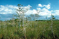
The Everglades in Florida

The Teton Range in Wyoming

The Monument Valley in Utah
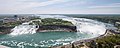
Niagara Falls from the Skylon Tower seen

Columbia River (in Oregon)


See also
Individual evidence
- ↑ www.usgs.gov The largest rivers in the USA. Accessed August 28, 2010.
- ↑ www.foresthistory.org ( Memento of the original from December 27, 2012 in the Internet Archive ) Info: The archive link was inserted automatically and has not yet been checked. Please check the original and archive link according to the instructions and then remove this notice. The 1910 story of the Great Fire on the US Forest History Society site.
- ↑ www.fs.fed.us (PDF; 2.9 MB) Basic report on the relationship between forest structure and forest fire by the US Department of Agriculture, April 2004.
- ↑ www.fws.gov List of endangered and threatened species published by the US Fish and Wildlife Service.
Web links
- USGS: Geographical provinces of the United States (English)
- Topographic map of the USA (JPEG, 4.5 MB)
23 North American member states of the United Nations :
Antigua and Barbuda |
Bahamas |
Barbados |
Belize |
Costa Rica |
Dominica |
Dominican Republic |
El Salvador |
Grenada |
Guatemala |
Haiti |
Honduras |
Jamaica |
Canada |
Cuba |
Mexico |
Nicaragua |
Panama |
St. Kitts and Nevis |
St. Lucia |
St. Vincent and the Grenadines |
Trinidad and Tobago |
United States
Dependent Areas:
US Virgin Islands |
Anguilla |
Aruba |
Bermuda |
British Virgin Islands |
Greenland |
Guadeloupe |
Cayman Islands |
Martinique |
Montserrat |
Navassa |
Netherlands Antilles |
Puerto Rico |
Saint Barthélemy |
Saint-Martins |
Saint-Pierre and Miquelon |
Turks and Caicos Islands
Geography of the States of:
Africa |
Asia |
Europe |
Oceania |
South America