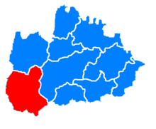
Gmina Andrychów
| Gmina Andrychów | ||
|---|---|---|

|
|
|
| Basic data | ||
| State : | Poland | |
| Voivodeship : | Lesser Poland | |
| Powiat : | Wadowicki | |
| Geographic location : | 49 ° 52 ′ N , 19 ° 20 ′ E | |
| Residents : | s. Gmina | |
| Postal code : | 34-120 | |
| Telephone code : | (+48) 33 | |
| License plate : | KWA | |
| Economy and Transport | ||
| Street : | Krakow - Bielsko-Biala | |
| Rail route : | Bielitz-Biala - Kalwaria Zebrzydowska | |
| Next international airport : | Krakow | |
| Gmina | ||
| Gminatype: | Urban-and-rural parish | |
| Gmina structure: | 7 school offices | |
| Surface: | 100.60 km² | |
| Residents: | 43,575 (Jun. 30, 2019) |
|
| Population density : | 433 inhabitants / km² | |
| Community number ( GUS ): | 1218013 | |
| Administration (as of 2015) | ||
| Mayor : | Tomasz Żak | |
| Address: | Rynek 15 34-120 Andrychów |
|
| Website : | www.um.andrychow.pl | |
The Gmina Andrychów is an urban-and-rural municipality in the powiat Wadowicki of the Lesser Poland Voivodeship in Poland . Its seat is the city of the same name with around 20,700 inhabitants.
history
Partner communities
- Isny im Allgäu , Baden-Württemberg, since 1998
- Břeclav in South Moravia, Czech Republic, since 2005
- Landgraaf in the Limburg province of the Netherlands, since 2008
- Priverno in Lazio, Italy, since 2008.
structure
The urban and rural community consists of the eponymous city and the following villages:
economy
Tourism is an important industry in the municipality. The nature reserve ( Rezerwat przyrody Madohora ) and the Little Beskids offer a delightful environment. There are separate slopes and 400 km of cycle paths for mountain bikes and cyclists.
Web links
Commons : Gmina Andrychów - collection of images, videos and audio files
- City and municipality web presence (Polish, German and English)
Individual evidence
- ↑ population. Size and Structure by Territorial Division. As of June 30, 2019. Główny Urząd Statystyczny (GUS) (PDF files; 0.99 MiB), accessed December 24, 2019 .
- ↑ The city's website, Urząd Miejski w Andrychowie , accessed on February 7, 2015

