
Hörnli (mountain)
| Hörnli | ||
|---|---|---|
 Hörnli |
||
| height | 1133 m above sea level M. | |
| location | Canton of Zurich , Switzerland | |
| Dominance | 3.55 km → Roten | |
| Notch height | 178 m ↓ at Älpli | |
| Coordinates | 713 525 / 247771 | |
|
||

The Hörnli ( 1133 m above sea level ) is a mountain in the municipality of Fischenthal in the east of the canton of Zurich in Switzerland . The popular panoramic mountain in the Zurich Oberland lies entirely within the canton.
Neighboring mountains
Immediately north of the Hörnli (415 m as the crow flies) lies the Chlihörnli ( 1073 m above sea level ), on the summit of which the Zurich communities Fischenthal and Bauma meet. Also north of the Hörnli (570 m as the crow flies) and northeast of the Chlihörnli (260 m as the crow flies), lies at 992 m above sea level. M. the three-country stone between the cantons of Zurich, St. Gallen and Thurgau .
meteorology
Despite the relatively low altitude of 1133 m above sea level. M. can occur at the Hörnli West foehn , which can be observed especially in the lower Toggenburg with temperature increases of up to 5 degrees Celsius. The Hörnliföhn occurs about five times a year. It is difficult to forecast, the wind must be blowing from the west.
Land survey
On the Hörnlikuppe there is a measuring point of the first order country triangulation. Until 1950 this consisted of an observation pillar, which was towered over by a pyramid signal. The subterranean center of the actual TP 1st order still exists, the pyramid was renewed in 2000 and provided with an explanation board. The Hohentwiel , Hersberg (near Immenstaad), Säntis , Scheye , Rigi and Lägern stations were observed from the Hörnli station .
Telecommunications tower
Swisscom operates a telecommunications tower on the Hörnli. ARTG's HB9AK amateur radio relay for shortwave radio (operating modes Pactor 1–4, Robust Packet) and 2m radio data transmission ( Packet Radio AX.25) is also located on the system. The operating frequencies are 144.875 MHz in the 2-meter band and 28.311 MHz in the 10-meter band .
Climate table
| Hörnli, 1981-2010 | ||||||||||||||||||||||||||||||||||||||||||||||||
|---|---|---|---|---|---|---|---|---|---|---|---|---|---|---|---|---|---|---|---|---|---|---|---|---|---|---|---|---|---|---|---|---|---|---|---|---|---|---|---|---|---|---|---|---|---|---|---|---|
| Climate diagram | ||||||||||||||||||||||||||||||||||||||||||||||||
| ||||||||||||||||||||||||||||||||||||||||||||||||
|
Average monthly temperatures for Hörnli, 1981–2010
Source:
|
||||||||||||||||||||||||||||||||||||||||||||||||||||||||||||||||||||||||||||||||||||||||||||||||||||||||||||||||||||||||
The maximum value for the average temperature in January was reached in 2020 with 2.3 ° C. This broke the previous record of 2018 (2.2 ° C). The maximum value for the average duration of sunshine in January was also reached in 2020 with 148.0 hours. This broke the previous record of 1996 (137.8 hours).
tourism
In the Middle Ages and the early modern times, the Schwabenweg passed the Hörnli as part of the Jakobsweg , and since 2008 the path has been signposted as national hiking route 4 ViaJacobi (Kreuzlingen branch), Fischingen - Rapperswil stage from Wanderland Schweiz .
The Hörnli can be reached from Steg in about two hours of walking, from Allenwind in 45 minutes.
To the west, a little below the Hörnlikuppe is the Berggasthaus Hörnli . The anticipated panoramic view of the Hörnli is somewhat blocked by the trees that have grown tall on the north side in recent decades.

View from near Bachtel from

Berggasthaus Hörnli
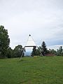
Survey signal pyramid

Explanation board

Dreiländerstein

View from Rütiwis below Schnebelhorn


Web links
- Berggasthaus Hörnli
- Description of the ViaJacobi on Wanderland Schweiz
- Hörnli tour reports and photos
- Photos and view from the Hörnli
Individual evidence
- ↑ Urban Rechsteiner: The peculiar winds of the east . Westföhn am Hörnli. In: St. Galler Tagblatt . December 22, 2016, p. 15 .
- ↑ SWISS_ARTG: Hörnli. Retrieved July 21, 2019 .
- ↑ Climate table. (PDF) (No longer available online.) In: meteoschweiz.admin.ch. meteoschweiz, formerly in the original ; Retrieved April 8, 2017 . ( Page no longer available , search in web archives ) Info: The link was automatically marked as defective. Please check the link according to the instructions and then remove this notice.
- ↑ Felix Blumer: Records in January - records for temperature and sunshine duration. In: srf.ch . February 1, 2020, accessed February 4, 2020 .
← Previous location: Au TG | Hörnli (mountain) | Next town: Fischenthal →