Hausberg (Taunus)
| Local mountain | ||
|---|---|---|
|
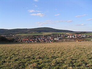
The local mountain from the south with the village of Münster in the foreground |
||
| height | 485.7 m above sea level NHN | |
| location | at Hoch-Weisel ; Wetteraukreis , Hessen ( Germany ) | |
| Mountains | Taunus | |
| Dominance | 2.75 km → rearmost head | |
| Notch height | 53 m | |
| Coordinates | 50 ° 24 ′ 41 " N , 8 ° 36 ′ 55" E | |
|
|
||
| particularities | Hausberg Tower ( AT ) | |
The local mountain near Hoch-Weisel in the Hessian Wetteraukreis is 485.7 m above sea level. NHN high elevation in the Taunus . Its peripheral location to the Wetterau, which is around 200 m lower, makes it a striking mountain figure for Butzbach and the surrounding area.
Geographical location
The local mountain is located in the north of the eastern Hintertaunus on the border of the Taunus and Wetterau . In the Taunus Nature Park , it is located about 1.7 km northwest of Hoch-Weisel, a south-western district of Butzbach . To the north-west of the mountain lies Espa (to Langgöns), to the north Hausen-Oes and south of Münster (both to Butzbach). Its eastern foothills are called Kleiner Hausberg , to the southwest the landscape leads over to the Bruler Berg ( 424.2 m ).
Natural spatial allocation and fauna-flora habitat
The local mountain belongs to the natural spatial main unit group Taunus (No. 30), in the main unit Eastern Hintertaunus (302) to the natural area Bodenroder Kuppen (302.2), with the main unit Wetterau (234) with the sub-unit northwestern Wetterau (234.2) and the natural areas to the east Connect the Butzbach basin (234.20) and Mörlener Bucht (234.21).
On the south -eastern flank of the mountain lies the fauna-flora-habitat area Wacholderheide and orchards near Hoch-Weisel (FFH no. 5517-302; 13 hectares ).
Ring wall, Limes and fort
Remains of Celtic ramparts from the La Tène period exist on the local mountain and the neighboring Brül mountain , the archaeological investigation of which began in 1911. The Upper German-Raetian Limes ran in the vicinity of the local mountain . The remains of the small Roman fort Hunnenkirchhof are at the foot of the Kleiner Hausberg .
Hausberg Tower
The first observation tower was built on the local mountain as early as 1873 . This was badly damaged by a hurricane in 1875, repaired again in 1876 and then remained in place until 1941 when it was demolished due to dilapidation. On June 1, 2007, the Hausbergturm e. V started the construction of a new tower, which was inaugurated on May 31, 2008 as the Hausberg tower . The tower is 23.25 m high and has a covered viewing platform at 19 m height, which is accessible via 98 metal steps of the staircase arranged diagonally in the tower. Panorama orientation boards are attached to the parapets of the platform.
From the observation deck of the tower, the eye is not only down to Butzbach , but it also offers a 360-degree panoramic view overlooking among others to the south, west and north-west over the Taunus with the High Taunus and the Eastern Hintertaunus , to Wetterau (northeast, east and southeast), to the Westerwald (northwest), to the Siegerland (northwest), to the Rothaargebirge (northwest), to the Wittgensteiner Land (northwest), to the Burgwald (north), to the Gladenbacher Bergland (north), to Gießen ( North), to the Kellerwald (northeast), to the Knüllgebirge (northeast), to the Vogelsberg (northeast and east), to the Rhön (east), to the Spessart (southeast) and over the lower Taunushauptkamm at the Saalburgpass to the Odenwald (south).
Since 2015, the wooden struts on the south and west sides of the tower have been protected against weathering with zinc sheet covers.
Traffic and walking
The state road 3053 ( Espa - Hausen - Butzbach ) leads north past the Hausberg , south the L 3353 ( Bodenrod - Münster - Fauerbach vor der Höhe ), southeast the district road 15 (Münster- Hoch-Weisel ) and east the L 3056 (Hoch- Weisel-Butzbach). For example, starting at these roads, you can get to the summit on forest trails and paths. The European long-distance hiking trail E3 leads north past the mountain through Hausen .
Panoramic photo
literature
- Fritz-Rudolf Herrmann : The ring walls on the local mountain near Butzbach. In: Find reports from Hessen Supplement 1 - Festschrift W. Dehn , Bonn 1969 pp. 58-68 (also in: Wetterauer Geschichtsblätter 19, 1970, pp. 1-9).
- New view of the old ramparts. A lookout tower for the local mountain near Butzbach ( memento from November 5, 2010 in the Internet Archive ) - copy of an article from the FAZ from May 26, 2008 (p. 50; PDF file; 19 kB), accessed in the Internet archive on 27 January 2016
- Local mountain . In: Heinrich August Pierer , Julius Löbe (Hrsg.): Universal Lexicon of the Present and the Past . 4th edition. tape 8 . Altenburg 1859, p. 97-98 ( zeno.org ).
See also
Web links
Individual evidence
- ↑ a b c Map services of the Federal Agency for Nature Conservation ( information )
- ↑ The Hausbergturm on hausbergturm.de


