
Heidenschanze near Dresden
| Heidenschanze | ||
|---|---|---|
 Rocks at the Heidenschanze in Dresden-Coschütz, June 2014 |
||
| Alternative name (s): | Buistrizi; Coschütz Castle Hill; Coschützer Burgberg; Vineyard; the Heidenschanze near Dresden, near Coschütz, in the Plauschen Grund | |
| Creation time : | Bronze Age to Early Iron Age, Slavic, early German reuse | |
| Castle type : | Spur attachment with section wall | |
| Conservation status: | Wall remains | |
| Standing position : | Burgward | |
| Construction: | Wooden box construction | |
| Geographical location | 51 ° 1 '12.8 " N , 13 ° 41' 16.7" E | |
|
||

The Heidenschanze is a prehistoric and early historical fortification at Coschütz am Plauenschen Grund between the cities of Dresden and Freital .
Location and description
The plant is situated on a Monzonite - Felssporn (coordinates 51.020223 N, O 13.687977 ) on the right side about 90 meters above Plauenschen base ( 220.8 m above sea level. Northwest of the village Coschuetz above) Weißeritz . It was secured by a section wall up to eleven meters high with a defensive moat in front . Selected finds from the Heidenschanze near Dresden are exhibited in the State Museum of Archeology in Chemnitz . They illustrate the topic of metallurgy .
The Heidenschanze is considered to be the most important prehistoric ground monument near Dresden and is seen as the center of a settlement center between the Elbe valley and Tharandt .
The federal highway 17 passes under the system in the Coschützer tunnel .
history
In the immediate vicinity is the former " sandstone quarry at the Heidenschanze" of Alt-Coschütz, the oldest layers of which belong to the Calycoceras naviculare - zone of the lower upper cenomanium . From the time of the band ceramics around 5000 BC. A deposit has come down to us that shows that the imposing rock was of particular importance in this early period. The oldest archaeological evidence of human settlement is dated to the late Central European Bronze Age around 1300 BC. The excavation results indicate that the wall was built between 1200 and 500 BC. Existed. By Reinhard Spehr that would castle two hundred years older: The first fortification was apparently created in the Middle Bronze Age (around 1400 BC..). The plant's decline may be related to changing trade in copper , tin, and bronze . A connection with the abrupt end of the Lusatian culture as a result of strong incursions by Scythians who invaded the area would also be possible. Especially in the first half of the 1st millennium BC, the castle was the most important settlement in the Dresden Elbe valley basin . Around the year 1000 BC The complex was on fire, and the sandstone turned reddish in color under the heat of the fire. Around 800 BC The only unprotected access was closed by an approx. 70 meter long wall. In addition to the main rampart, there is at least one more rampart in front of the current buildings at Coschütz, which protected a much larger outer bailey.
After a fire , the plant was rebuilt, but then fell victim to another devastating conflagration, which developed such heat that it caked the earth and slagged stones . The wall was built from a row of wooden boxes filled with earth and stones and was originally thought to have been up to 20 meters high. Access is not documented and is likely to have fallen victim to quarrying . Contrary to this assumption, the wall on the Freiberg Meilenblatt from 1780 shows a similar appearance as on maps and illustrations at the end of the 19th century. Today's access runs diagonally southwest along the wall and makes a slight ascent. While the wall steadily decreases in height, the access on the side facing away from the wall is flanked by an increasing steep slope . The course will thus have favored the defense of the access.
The structures of the castle are evidence of extensive construction activities. The rock surfaces were elaborately terraced at various points in order to create even surfaces. Presumably the entire inner area was closely built up. The cultural layers , which are up to 7 meters thick, suggest enormous structural dynamics . The craftsmen's metal melting furnaces were concentrated on the slope, probably to protect the wall and the inside of the castle from flying sparks. In addition to domestic animals such as cattle and pigs , bone finds also show a high proportion of wild animals , which can be explained by the proximity to the uninhabited and forested foothills of the Ore Mountains . Remnants of human bones can be related to a cruel sacrificial rite or war trophies , as in contemporary castles in Bohemia . 4 Bronze Age depot finds are known on the castle grounds . The ceramic remains , bone work, ovens and metal finds that were found indicate the wealth of the inhabitants of Heidenschanze. The location of the castle on a path from the Elbe over the mountain ranges between the then impassable Weißeritz and the Kaitzbach to Bohemia was favorable. In the late Bronze and Early Iron Ages , Heidenschanze was probably the most important castle in the Dresden Elbe Valley. According to Judith Oexle , the complex is more likely to have resembled a medieval settlement, making it a prehistoric predecessor of Dresden.
.jpg)
After a settlement gap of around 1400 years (500 BC - 900 AD), the place was reoccupied by Slavs since the 9th century, at the latest since the expansion of the Great Moravian Empire at the end of the century . As on the Burgberg in Niederwartha , typical Hungarian arrowheads were found on the Heidenschanze, which are related to the incursions of the equestrian nomads between 905 and 933.
According to a more classical view of German history, the settlement could have been conquered by Heinrich I during the German expansion to the east during his journey from Daleminzia to Bohemia. It is not even certain that this campaign led through Nisan, let alone specifically to Heidenschanze. In modern research, however, the prevailing opinion is that Meißen Castle was probably lost again immediately after the Saxon army withdrew, since there is no information about Meissen from the period from 929 to 968. Under these circumstances, there can be no question of a permanent East Franconian conquest of the Slavic Heidenschanze at the time.
In the Ottonian times , the castle was given the function of Burgward within the constitution of the German Empire . In the 10th century, a port and trading center on the Elbe , which was named Nisani , was built in the Burgward district 5 km north of the Heidenschanze . The city of Dresden developed from it at the end of the 12th century . In a donation from King Heinrich IV to the church of Meißen on October 28, 1068, the ski jump "burchwardo Bvistrizi" (1206 as "flumen (German: river) Bistrice") was listed and was thus named after the water that washes around the castle rock, the Weißeritz , named. Together (discovered in 1995) with a further, smaller and younger Ringwallanlage above Plauen (coordinates 51.025445N | 13.702575O) retained the castle until well into the 12th century, the military and political major function of the central part Gau Nisan. With main and outer bailey of the castle had a total area from 21,000 to 25,500 m² and was an important präurbanen forerunner of later developing city of Dresden After the Viscount of. Dohna of the 12th century end the Burgbauverpflichtung of the residents of the district Nisan of the city walls and the bridge of Dresden has concentrated, the Coschützer Burgward is abandoned . Only the round village of Coschütz, which was legally assigned and topographically connected to the castle, remained in existence .
In memory of the pagan prehistoric times of the facility and owing to the fact that prehistoric finds were repeatedly brought to light during plowing work inside the facility, it was given the popular name "Heidenschanze" over time. The facility was once called Coschützer Burgberg or Coschützer Schanze, while the name Heidenschanze was established in the course of the 19th century. On the Freiberg Meilenblatt from 1780, a kind of path construct to lower terraces is depicted at the northeastern end of the hill. Despite the increasing number of finds in the fields of what was then known as the vineyard since the end of the 18th century, the first archaeological excavations of the Heidenschanze did not begin until 1851 when the quarry was operating at the same time . The quarry made one flank of the mountain spur even more inaccessible, but changed the appearance and size in the south-west and north of the complex a lot. The aim of the former quarrying activity was the Monzonit des Plauenscher Grund, formerly known as the Syenit Plauenscher Grund . Large quantities of the pavement for the Dresden region come from the Plauen reason and were extracted in a large number of other quarries. On top of the monzonite are thin Cretaceous layers in the form of planes , which are covered with Quaternary layers. To the east of the main castle, a quarry was also operated to promote Pläner. In 1864 the ISIS scientific society identified the area as a fortification. In 1865, an event took place on the grounds of the 1st German Singers ' Association. In 1870, the Dresden court pharmacist Caro and the Coschütz landowner Körner made a puncture through the castle wall. In the second half of the 19th century it is reported that the highest point of the wall used to be reached by seven different, step-like sandstone slabs, which alternated with gravel and mud. Between 1871 and 1874 and 1896 the facility was examined several times by Rudolf Virchow .
Although smaller excavations were carried out, many areas of the ongoing quarry were excavated without prior investigation. In 1933 another wall cross-section was made. Another excavation campaign took place in the winter of 1940/41 by Hermann Dengler. By 1945 almost 15% of the inner area had been dismantled. After the war, Werner Coblenz carried out emergency excavations when the quarry was resumed , until the quarry was closed in 1963.

Heidenschanze (I) and Wall in Plauen (II), Freiberger Meilenblatt, 1780

Heidenschanze, topographic map, 1850

Heidenschanze (I) and Wall in Plauen (II), measuring table sheet, 1881

Heidenschanze and the copper hammer (powder mill, garrison mill), pen in black, watercolors, around 1800

Copper hammer (powder mill, garrison mill) in front of Heidenschanze, colored etching, around 1850

Heidenschanze, watercolor, 1890

Two views of the Coschützer Heidenschanze, lithograph, around 1891

Heidenschanze from the southwest towards the city center, aerial photo, 1933


Popular tradition
According to the residents of the area, a knight's castle is said to have stood in the area, which was destroyed by fire. There are said to be seven silver coffins in the cellars of the castle. This story led the owner to make a cut through the wall, which is known as the vineyard. However, only stones, earth, ashes, coals, bones and shards came to light. A more detailed tradition is said to contain the mortal remains of wealthy residents in the seven silver coffins. A settlement with the name “Küchendorf”, which cannot be proven historically, is also associated with the wall.
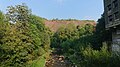
View northeast over the Weißeritz to Heidenschanze, September 2018
Today's access to Heidenschanze, September 2018
Remains of the rampart of the Heidenschanze, September 2018
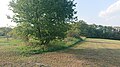
Another (outer) wall of the Heidenschanze, September 2018

View southwest to today's access to the Heidenschanze, the wall on the right, September 2018

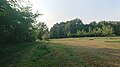
View southwest from the wall into the Heidenschanze, September 2018

View southwest from Heidenschanze to Freital, September 2018

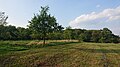
View northeast into the Heidenschanze, in the background the Wall, September 2018

View north to the Wall in Plauen (the trees in the back left in the picture), in the background the Plauen district, September 2018


literature
- C. Ambros: Animal remains from the Heidenschanze in Dresden Coschütz, publication Museum Ur- und Frühgeschichte 20, Potsdam 1986, 175–186.
- Georg Bierbaum: From Schanze to Schanze, a prehistoric hike in the south of Dresden, Geschichtliche Wanderfahrten 24, Dresden 1931, 14–34.
- Werner Coblenz: On the Bronze Age metal finds from the Heidenschanze in Dresden-Coschütz and their role in the temporal and functional significance of the castles of the Lausitz culture, work and research report sächsische Bodendenkmalpflege 16/17, 1967, 179–211.
- Werner Coblenz: The Heidenschanze in Dresden-Coschütz, In: H.-J. Vogt (Ed.), Archeologische Feldforschungen in Sachsen, Berlin 1988, 117–122.
- H. Dengler: Bone arrow tips from the Heidenschanze of Dresden-Coschütz, Sachsens Vorzeit 5, 1941 (1942), 51-69.
- Konstanze Jünger, Judith Schachtmann: The Coschützer Heidenschanze in Dresden. Early explorers and collectors. In: Archæo - Archeology in Saxony. Issue 8, 2011, 44–49. ( List of contents of the booklet PDF file; 264 kB )
- Harald Qietzsch and Heinz Jacob: The protected ground monuments in the Dresden district, Small writings of the State Museum for Prehistory Dresden, Issue 2, Dresden 1982, ISSN 0232-5446 , p. 30
- City Lexicon Dresden AZ. Verlag der Kunst Dresden 1995, ISBN 3-364-00300-9
Footnotes
- ↑ a b c d e f Judith Oexle (ed.), State Office for Archeology Saxony : Dresden 8000 , Dresden 2006, pp. 42–50
- ↑ H. Walther, P. Suhr: Proximal Tempestite from the deeper Obercenoman (naviculare zone) by Dresden-Coschütz. In: Freiberger Forschungshefte , Akademie-Verlag, Freiberg 1997, C468 (5): 305-317
- ↑ a b c d Reinhard Spehr , Herbert Boswank: Dresden, City Foundation in the Darkness of History, Dresden 2000, pp. 27–28
- ↑ Jost Grunert: The ski jumps of Upper Lusatia. In: Oberlausitzer Handbuch 2014, Bautzen 2014, pp. 145–148; see. Walter Frenzel : Picture handbook on the prehistory of Upper Lusatia. Bautzen 1929
- ↑ This is Dresden's oldest city wall. The Heidenschanze was laid out over 2,000 years before the city was founded. How the Nazis wanted to benefit from it and what's left of it. In: Sächsische Zeitung from October 19, 2019, with photos and video (accessed December 22, 2019).
- ↑ a b c d e Heidenschanze. In: Dresdner-Stadtteile.de. Lars Herrmann, accessed on September 20, 2018 .
- ↑ See e.g. B. Slavonic castle wall Dresden-Coschütz on slawenburgen.hpage.com (accessed on December 22, 2019).
- ↑ among others with Gertraud Eva Schrage: On the settlement policy of the Ottonians. Studies on the integration of the areas east of the Saale in the 10th century. In: sheets for German national history. Vol. 135, 1999, pp. 189-268, here: p. 204.
- ↑ Document book of the Margraves of Meissen and Landgraves of Thuringia (948–1234), ed. Otto Posse , Volume 1, Leipzig 1882, No. 136, p. 331
- ↑ Document book of the Hochstift Meißen, Ernst Gotthelf Gersdorf : Volume 1, Leipzig 1864, No. 29, p. 33
- ↑ a b c C. Ed. Fischer: About the Heidenschanze at Koschütz, in: Meeting reports and treatises of the Natural Science Society Isis, Dresden 1871, p. 58
Web links
- Heidenschanze on Dresdner-Stadtteile.de
- Geology & palaeontology of the former sandstone quarry at Heidenschanze
- 3D laser surface scans of the Heidenschanze area on the Saxony geoportal