Hohenhorst farmers
|
Hohenhorster peasantry (HB)
Isernhagen municipality
|
||
|---|---|---|
| Coordinates: 52 ° 28 ′ 53 ″ N , 9 ° 48 ′ 3 ″ E | ||
| Height : | 48 m above sea level NHN | |
| Area : | 12.48 km² | |
| Residents : | 4179 (December 31, 2018) | |
| Population density : | 335 inhabitants / km² | |
| Incorporation : | March 1, 1974 | |
| Incorporated into: | Warmbüchen | |
| Postal code : | 30916 | |
| Area code : | 0511 | |
|
Location of Hohenhorster Bauerschaft (HB) in Lower Saxony |
||
|
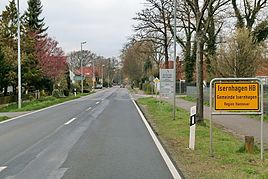
Entrance to Isernhagen HB from the direction of BAB 7
|
||
The Hohenhorster Bauerschaft (HB) is a district of the municipality Isernhagen in the Hanover region in Lower Saxony .
geography
The district is bordered by the Niedernhägener Bauerschaft to the south . To the west is the city of Langenhagen , to the north the municipality of Wedemark , to the northeast the city of Burgwedel and to the east other districts of the municipality. The seat of the municipality Isernhagen is with the town hall in the district Altwarmbüchen .
In contrast to the three other old villages of today's municipality of Isernhagen, the Hohenhorster farmers are not located on the elongated hill, but about 25 m deeper in the Wietzetal plain . It forms the north-western end of the horseshoe, as the old villages of Isernhagen are called due to their geographical location.
history
The Hohenhorst peasantry is a place that was laid out as an elongated Hagenhufendorf as early as the Middle Ages . The designation as a peasantry is based on the economic form of Burschap (peasantry) that is common in Low German areas . The name Hohenhorst is derived from the words hoch and Horst as well as high Horst . It describes a forest with tall trees, often oaks . The place is listed for the first time in 1445 in the register of the Celler Burgvogtei as "Honhorst". The street name “Branderiede” in HB indicates that early forest smiths melted iron from the lawn iron ore here .
On March 1, 1974, the community of Isernhagen, Hohenhorster peasantry was incorporated into the new community of Warmbüchen. This was officially renamed Isernhagen on June 1, 1975 .
politics
Local council
The local council consists of two councilors and five councilors. The local council also has two advisory members (SPD, FDP) .
(Status: local election September 11, 2016)
Local mayor
The local mayor of the Hohenhorst peasantry is Simon Müller (CDU). His deputy is Claus Hogrefe (FDP).
coat of arms
The draft emblem of Hohenhorster peasantry comes from the in Isernhagen born and later in Hannover living heraldry and crest painter peoples Gustav , who is also the emblem of Großburgwedel , Melle village , Wunstorf has designed and many other towns in the region Hanover. The coat of arms was awarded on November 22, 1954 by the Lower Saxony Minister of the Interior .
| Blazon : “A blue , right sloping beam in silver , covered with four upright, mutually covering, silver horseshoes . In the upper corner a sloping, green oak leaf to symbolize the typical Lower Saxon character of the village. " | |
| Founding of the coat of arms: The name Isernhagen is evidence of iron ore deposits that were proven to have been exploited here as early as around the year 900. This is what the horseshoes indicate. They should also remind you that horse breeding has been practiced successfully in Isernhagen for a long time. The number of four horseshoes was chosen to show the close ties between the independent political communities that make up a parish and a settlement unit. The blue, right sloping bar is supposed to symbolize the river Wietze . The coats of arms of the four municipalities must be viewed together, especially since the municipalities tried very hard to give themselves a uniform coat of arms. At the request of the Lower Saxony Minister of the Interior, however, each municipality had to include a distinctive symbol in its coat of arms. |
Culture and sights
Buildings
The townscape is characterized by a large number of very old, well-kept half-timbered houses and farms, which are often listed.
Architectural monuments
→ See: List of architectural monuments in Hohenhorster peasantry
Club life
- TSV Isernhagen from 1947 e. V.
- Isernhagen HB volunteer fire brigade from 1889
- Soldiers comradeship Isernhagen HB from 1882 e. V.
- Schützengesellschaft Isernhagen HB from 1954 e. V.
- Friends of the Friedrich-Dierks-Schule e. V.
Photo gallery
Fire station from 1950 in HB
Economy and Infrastructure
Companies
In the Hohenhorster peasantry there is a small town center with numerous shops to meet daily needs.
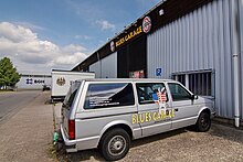
At its northern entrance to the town there is also an event center for rock and blues music, the Blues Garage .
Some well-known and international companies have their headquarters in Isernhagen HB, such as Heinz von Heiden Massivhäuser and Saaten-Union .
traffic
The district is conveniently located in terms of traffic. The state road 381, which runs through it, connects it directly to the federal motorway 7 in the north, and there is a close connection to the federal motorway 2 in the south .
The Hanover – Celle – Hamburg line is connected to the local train station. The metronome railway company operates there . Two bus lines of the Greater Hanover transport serve the internal development and the connection with other Isernhagener districts as well as with neighboring communities.
Hannover- Langenhagen Airport is in the immediate vicinity .
literature
- Claudia Kempf-Oldenburg, Jes Tüxen: Isernhagen Chronicle. Volume 1. Ed .: Isernhagen municipality, December 1990
- Claudia Kempf-Oldenburg, Jes Tüxen: Isernhagen Chronicle. Volume 2. Ed .: Municipality of Isernhagen, December 1992
- Heinz Koberg : Our Isernhagen. Ed .: Isernhagen municipality, March 1984
Web links
Individual evidence
- ↑ a b Facts and Figures. In: Website of the community Isernhagen. December 31, 2018, accessed April 17, 2019 .
- ^ Federal Statistical Office (ed.): Historical municipality directory for the Federal Republic of Germany. Name, border and key number changes in municipalities, counties and administrative districts from May 27, 1970 to December 31, 1982 . W. Kohlhammer, Stuttgart / Mainz 1983, ISBN 3-17-003263-1 , p. 222 .
- ^ Federal Statistical Office (ed.): Historical municipality directory for the Federal Republic of Germany. Name, border and key number changes in municipalities, counties and administrative districts from May 27, 1970 to December 31, 1982 . W. Kohlhammer, Stuttgart / Mainz 1983, ISBN 3-17-003263-1 , p. 197 .
- ^ A b Local council of the Hohenhorst peasantry. In: Website of the community Isernhagen. Retrieved August 14, 2017.
- ^ A b Landkreis Hannover (ed.): Wappenbuch Landkreis Hannover . Self-published, Hanover 1985, p. 200-201 .


