
Köttingen (Erftstadt)
Köttingen is a northeastern part of Erftstadt in the Rhein-Erft district . The place is between Liblar and Kierdorf . He was best known for the May works located there.

history
Prehistoric time
Research into the first settlement of the area around Köttingen leads back to the Latène period . The findings of several burial mounds , carried out by an excavation team of the Cologne archaeologist Peter Anton Tholen , showed that they could be assigned to this time and thus proved a settlement between Köttingen and Kierdorf .
Roman and Frankish times
In Roman times an army road ran between the forts Vicus Bonnensis and Novaesium (Neuss), along the course of which Köttingen was founded in Franconian times. The name Köttingen, which occurs frequently in western Germany, cannot be clearly explained. The place names with the ending –ingen originated at the same time as the place names ending with –heim. The name researcher Heinrich Dittmaier assumes that the name, which is not related to a person, denoted the inhabitants of a place.
middle Ages
First mentions
The place was first mentioned in a document in 1166, when the abbess of the Dietkirchen monastery near Bonn bought back tithe rights that had been alienated.
The first residents mentioned in a document were the "free" Heinrich, Albert and Adelheid and their relative Heinrich, who gave up their freedom in 1239 and became wax interest from the St. Kunibert monastery in Cologne.
Clergy and noble property
In the 15th century, the Dietkirchen Abbey had several feudal courts in Köttingen, all of which provided a court jury for the Fronhof in Liblar and whose duties were compulsory for the electorate . In 1598 this Fronhof in Liblar belonged to four feudal farms in Köttingen. Two of them were given to aristocrats , the third, called the “Wedemhof”, was held by the Liblar pastor and the fourth by the abbot of the St. Pantaleon Monastery in Cologne. As early as the 13th century, the St. Pantaleon Monastery had acquired property and income in Köttingen and, in 1463, the Dietkirchener Lehnshof from the "von Linzenich" couple. In later times, some fiefdoms consisted only of lands such as the fiefdom that was given to the owners of the Blessem Castle and the court of the Lords of Horst, which fell to Wolff-Metternich .
Modern times
Living conditions of the villagers

Köttingen was on the medieval military road Bonn- Swisterberg- Liblar-Kierdorf- Brüggen - Blatzheim - Aachen . The village belonged to the Honschaft and parish Liblar in the Amte Lechenich , after 1630 to the subordinate Liblar. In 1660 Köttingen consisted of twelve farmhouses and farms. In a census in 1770, 24 families in the village who were compulsory for the Gracht family were recorded. A few had up to 15 acres of arable land, most cultivated a few quarters to a few acres of land, of which they paid the basic rent and delivered the tithe to Dietkirchen Abbey.
Broichrechte
Originally, pastures and communal areas were the general property of the Kötting villagers. With the Broichrechte, in which the Dietkirchen fiefs also owned shares, the use for deforestation for personal use and later for turf reclamation was connected. In the course of time, shares in the Gemeindebroich came into the possession of the individual Köttinger families and were split up in the 16th century by dividing inheritance . The families often sold their Broich shares out of economic hardship, so that around 1770 the Köttinger Broich was almost entirely owned by Count Wolff Metternich. However, the residents were allowed to collect wood in the Ville on specified days .
Wars and fires
Köttingen was one of the places that were set on fire during the siege of Lechenich in 1642 . In 1672 Köttingen was set on fire again during the Dutch War .
Use of brown coal in the 17th and 18th centuries
Already at the beginning of the 17th century, the lignite mining began in small quantities, because in 1630 a "Klautentrettersche" ( Klüttentreterin ) from Köttingen was called. In the 18th century and at the beginning of the 19th century, the owners of small "Klüttenkaulen" let them be exploited by workers. The workers were day laborers who earned their livelihood in the squares when they could find no other employment. As a sideline, they cultivated small agricultural areas. When, according to the Mining Act of 1810/1812, lignite could only be mined with a state license , the small private quarries disappeared and many Köttinger worked in the licensed pits.
French time
When a new administration and judiciary was created on behalf of the French government in 1798, Köttingen belonged to the municipality of Liblar. After the introduction of the Mairien under Napoleon , Köttingen remained with the municipality and Mairie Liblar in the canton of Lechenich .
According to the population lists drawn up by the French administration, Köttingen had around 119 inhabitants in 1799, including 27 children in 36 households. Three of the heads of households were farmers, and working-class families lived in 23 households .
The ecclesiastical farms were expropriated in the secularization of 1802 and sold in the following years.
Prussian time

Anna chapel around 1840

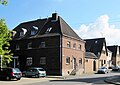
Square courtyard around 1867

Elementary school from 1889

Preserved half-timbering in the townscape


During the Prussian period, Köttingen still belonged to the municipality of Liblar and was administered from there.
The membership of the Catholic parish in the Liblar parish continued in the 19th century. From 1840 to 1841 the St. Anna chapel was built in place of the former court chapel of a Dietkirchen feudal courtyard, in which the Liblar pastor occasionally celebrated mass.
In 1889 Köttingen had its own school building on Heerstraße (today Peter-May-Straße) so that the children could be taught on site and no longer in the elementary school in Liblar, as was previously the case.
At the end of the 19th century, Köttingen's transport connections also improved. The place received a stop of the Mödrath-Liblar-Brühler railway . In 1911 the place received a water pipe and in 1913 it was connected to the regional electricity network.
At that time, the houses in the village were located on Heerstraße, as they have always been, with a modest center around the Anna chapel, the school and several restaurants. The Kyrionshof, which was expanded into a large square courtyard in 1867, was located on Bahnhofstrasse (today Waldstrasse).
For the industrial mining of lignite after 1897 and its further processing into the coveted fuel briquette , additional workers were required who settled in Köttingen. So the place grew to about 400 inhabitants by the First World War. It was also the time when the first briquette presses were constructed, which increased production and on the one hand saved jobs, but also created new jobs with an expansion such as in the Rhenish lignite mining area .
Weimar period

former consumer shop built in 1923

former elementary school built in 1923
Houses in the miners' settlement around 1921

House of the miners' settlement built in 1921


RWE's lignite needs, which had grown to become the largest electricity producer in the region, also needed miners after the First World War . These were recruited in economically weak areas such as the Eifel , the Palatinate and the Bavarian Forest to settle in Köttingen.
In the years from 1921 to 1923, the "Housing Association for the Rhenish Brown Coal District" created a large, contiguous settlement that was built especially for the miners. The center of the new settlement was the new church square in the east of the village, with a church, school, teacher's apartments and a general store, Konsum . Around this center, 190 houses were built in seven rows of streets, designed as single-family or semi-detached houses with attached laundry rooms. The houses had a small front garden and at their backs had small stables for keeping cattle and a kitchen garden. Small arched passages between the houses led from the street to the gardens. The settlement was connected to the electricity and water supply network, but there was initially no sewer system. There was a kindergarten for the younger children, which was followed by a gym.
The new residents of Köttingen mainly worked in the lignite mining of the Roddergrube , but they also found work in Zieselsmaar , Liblar and Knapsack . They lived without close contact with the long-established Köttingians and founded their own clubs such as the Bayernverein, the theater club, and music and sports clubs. It was not until after the end of the Second World War that the mutual reservations between the locals and the new citizens settled and the mutual distrust was broken.
The new four-class school for all Köttinger children, built in 1923, was located in the new settlement near the church. It replaced the old elementary school, which did not offer enough space due to the increased number of students. In 1922 the foundation stone was laid for their own church in the new settlement, the construction of which was delayed during the inflationary period and could only be completed in 1924. The church with a simple main nave and choir as well as a side aisle was built according to plans by the Cologne government master builder Johann Mertzenich.
The time of the global economic crisis also hit the people of Köttingen. At times there were more unemployed than employed people, but garden yields and keeping pets could alleviate the greatest need.
The residents of the settlement were politically “left-wing”, the other residents traditionally chose the center . In the 1933 elections, the SPD's share of the vote was 26.5%. The KPD accounted for 22.9%. The NSDAP had hardly any supporters in Köttingen, even in the election in March 1933 it only achieved 5%.
time of the nationalsocialism

After 1933 the parties under the new rulers were subjected to reprisals until they were banned . Workers who were politically active outside the NSDAP were threatened with dismissal. Also founded in 1923 by members of the SPD SSV Köttingen had difficulties could be resolved only when the sports club into line was and the West Germans had joined Game Association.
During the Second World War , the church was hit by fire bombs during an air raid in 1942 and burned down.
After the Second World War
After the Second World War, the Liblar community made efforts to accommodate refugees . In Köttingen over 200 displaced persons were taken in, to whom the municipality made building land available. Another urgency was to repair the war damage to the buildings and to develop the streets and sewers. When the streets were widened and the sidewalks were laid, the small front gardens disappeared.
There were also changes in the church and school sector. The burnt-out church could be restored by 1948. In 1952 Köttingen was separated from the Liblar parish and became its own parish, which today is part of a larger pastoral care area.
The Köttinger elementary school was dissolved in 1968 as part of the school reform and the secondary school students were assigned to the secondary school in Liblar. The primary school students could initially continue to use their rooms, but were subordinate to the Oberliblar primary school. After another change, the reorganization of the school districts in 1978, the school-age children attend the St. Barbara-Concordia primary school in Kierdorf.
Until June 30, 1969, Köttingen belonged to the municipality of Liblar.
Today's townscape

Köttingen extends on both sides of the town's main artery, Peter-May-Straße. From the old center of the village, the St. Anna Chapel , which was completely restored after a fire in 1978 in the following years up to 1982, has been preserved on this street , as well as the old school building, while the two inns no longer exist. To the west of the road are the May works and a large new building area called "Längsbusch", east of the road is the other part of Köttingen on a slight slope. There is the parish church on the church square, on which most of the streets of the former workers' settlement already lead. From this square, which is still the center of the village today, you can take Franz-Lehnen-Straße to the newly created Rheinflottenplatz, a park-like green space on which a briquette press from the year on Franz-Lehnen-Straße is a reminder of the mining era Founded in 1915.
The Peter-May-Halle, completed in 1997, the former kindergarten, the current clubhouse of the Rose Theater Association, the adjoining gym and the clubhouse of the "Rheinflotte" as well as the parish home and the municipal family center with daycare center are grouped around Rheinflottenplatz .
Furthermore, the residential buildings that have been newly built in recent decades, some of which were built as company apartments, are located here, as well as a fairly uniformly designed settlement "Hubert-Rüttger-Straße", a project implemented by Bauverein Erftstadt with 240 rental apartments Years have been restored.
The buildings surrounding the church have undergone major changes in their use over the past few decades, only the rectory next to the church fulfills its old function. The town's youngest school became the city of Erftstadt's children's, youth and community center, which also houses a private day-care center. Apartments were set up in the former teacher's house and the adjoining "Konsum" store.
After the housing association had sold properties and houses to the residents in 1954, they now invested in their renovation as owners. With the increasing motorization and the introduction of corresponding household appliances, laundry rooms that were no longer needed were converted into garages.
The houses in the former workers' settlement have been adapted to today's living comfort, but many details of the old structures have been preserved. In many cases the narrow house widths, the low gable heights or the staircases that start directly on the sidewalk are reminiscent of the past.

In the vicinity of the Anna Chapel, the small Annengartenplatz with a memorial, a work by Erftstadt artist Hannelore Goetz, was built in place of the earlier gardens. The three pillars commemorate the destruction, reconstruction and memory of the dead of the two world wars.
Köttingen grew from 1700 inhabitants in 1930 to 2300 inhabitants in 1969. Today Köttingen has 3641 inhabitants (as of March 31, 2018). Alfred Zimmermann has been the local mayor since 1979 (as of April 2018).
In Köttingen, doctors and pharmacies are on site. The place also has a fire station . A small inn is still on site, as well as a bakery and a bank branch. The nearby shops in Liblar and in the EKZ offer shopping opportunities for daily needs. Several medium-sized companies have settled in the newly created industrial park between Liblar and Köttingen.

Madonna above the portal of St. Joseph

Annagartenplatz, memorial for those who died during the two world wars.

Peter May Halle built in 1997

Briquette press Ville I from the Knapsack briquette factory from 1915


All associations are represented in the Köttinger village community. Cultural events of the associations, including the carnival celebrations, take place in the Peter May Hall, which was built in 1997. For this municipal facility, the village community concluded a usage contract with the city of Erftstadt in which they were given the management of the hall. In 2003 the village community published a small illustrated book on the subject of "Köttingen in old pictures".
The heavily frequented Peter-May-Straße running through Köttingen, the former Heerstraße, connects Köttingen with Liblar and Kierdorf. The bus routes 955 Liblar Bahnhof, Türnich, Horrem and the bus route 977 Liblar Bahnhof, Türnich, Frechen, which connect Köttingen to local traffic, also pass through it. The next motorway junctions are Erftstadt and Erftstadt-Gymnich of A 61 or A 1 / 61 .
Maywerke

Today, the townscape is strongly characterized by the May-Werke facilities to the west of Peter-May-Straße, which developed into the largest employer in Erftstadt.
Company founder Peter May started a grocery store in 1922, which he expanded in 1924 in Köttingen into a wholesale company in this branch. In 1955, May Werke was founded, initially producing canned condensed milk. This specialized range of production was expanded in the 1980s to include other dairy products, including coffee and spray cream in various dosage sizes. In 1995 the company was reorganized. In May-Werke GmbH & Co. KG, several independent companies merged under the leadership of May Holding GmbH & Co. KG. Among the companies that relocated one of their headquarters to Köttingen are Hochwald Nahrungsmittel-Werke , whose dairy products are packaged there. Another resident company, the metal packaging manufacturer Impress Group, was acquired by the Ardagh Group . One focus of the SDI group of companies is the manufacture and sale of soft drinks and mineral water. A mineral water spring was developed on the company premises at a depth of 300 meters, the water of which has been processed by the SDI group in Köttingen since 2006 and filled into plastic bottles. The mineral water is marketed by some discounters under the name “Fiorelino”. The company's own long-distance trucks deliver and transport the Köttinger products.
Attractions
The place has some objects that have been placed under monument protection. These include the Anna Chapel, a brick building from the 19th century, and the old square courtyard (brick and half-timbered) from 1867, but also the church and its rectory, both of which and a former school show the architectural style of the early 20th century . Some of the residential buildings and a commercial building from the Köttingen lignite era built on Kirchplatz are also subject to monument protection. A relic of industrialization also reminds of this, a disused briquette press from 1915, which was set up on one of the local green spaces.
Köttinger See
The Köttinger Lake is located north of the town and how the rest of Ville lakes in the conservation area . Hiking trails lead through a mixed deciduous forest around the lake, whose fish stocks are managed by AIG Ville eV Köttingen.
literature
- Cornelius Bormann : Köttingen, the place with two faces and one family. In: Yearbook of the City of Erftstadt 2003.
- Hans-Paul Müller: 50 years of St. Josef Köttingen . Liblar 1974.
- Gabriele Rünger: Who voted for the NSDAP? In: History in the Euskirchen district. 1987.
- Peter Simons : Liblar . Liblar 1956.
- Karl and Hanna Stommel: Sources on the history of the city of Erftstadt . Vol. I-V. Erftstadt 1900–1998.
- Karl Stommel : The population lists from Erftstadt 1798–1801 . Erftstadt 1988.
- Otto Straznicky: The miners' settlement in Köttingen. In: Yearbook of the city of Erftstadt 1996.
- Hans-Paul Müller: Köttingen. Insight into the history of a village. (Period 1166 to the end of the 17th century, Sabine Doering-Manteufel, Angela Schlenkrich eds.) Helios-Verlag, Aachen 2008.
Individual evidence
- ↑ a b Peter Simons: Liblar. Liblar 1956 pp. 7, 65.
- ^ Heinrich Dittmaier: settlement names and settlement history of the Bergisches Land. Neustadt an der Aisch 1956, pp. 233–244.
- ↑ Landesarchiv NRW Düsseldorf inventory Dietkirchen certificate no. 6, published in: Karl and Hanna Stommel: Sources for the history of the city of Erftstadt. Volume 1 No. 17.
- ↑ Historical archive of the city of Cologne Holdings Kunibert certificate no. 1/48, published in: Karl and Hanna Stommel: Sources for the history of the city of Erftstadt. Volume 1 No. 69.
- ^ Landesarchiv NRW Düsseldorf inventory Dietkirchen files 35C Bl. 181-183.
- ^ Historical archive of the city of Cologne Stock Pantaleon certificate no. 3/398, published in: Karl and Hanna Stommel: Sources for the history of the city of Erftstadt. Volume 2, No. 1174.
- ^ Landesarchiv NRW holdings Kurköln II 1257 Bl. 5-55.
- ^ Archive Schloss Gracht files 85, therein residents' lists.
- ^ Archives Schloss Gracht files 553, 554, 556; Peter Simons: The community of Kierdorf. Liblar 1940, pp. 44-45.
- ^ Sarburg / Walram, Defense and triumph of the castle and the city of Lechenich against Hessian, French and Weimar troops in 1642. Cologne 1643
- ^ Karl Stommel: The Franciscans in Lechenich. In: Monasteries and monasteries in the Erftkreis. Pulheim 1988, pp. 266-268
- ^ Landesarchiv NRW Düsseldorf stock Kurköln XIII 166 (Court Liblar) Bl. 1-36
- ↑ Fritz Wündisch: From Klütten and Briquettes. Pp. 53-54.
- ^ Karl Stommel: The population lists from Erftstadt 1798-1801. Erftstadt 1988, pp. 286-291.
- ↑ W. Schieder (ed.): Secularization and mediatization in the four Rhenish departments, Canton Lechenich. P. 481.
- ↑ a b c d e Hans-Paul Müller: 50 years of St. Josef Köttingen. Liblar 1974.
- ↑ a b c Otto Straznicky: The miners' settlement in Köttingen. In: Erftstadt City Yearbook 1996. pp. 23–30.
- ^ City archive Erftstadt leaflet, inserted in the school chronicle with information on water disposal and the construction of a main collector for the municipality of Liblar
- ^ Willy Weyres: The church building in the Archdiocese of Cologne 1920-1931. In: Art gift of the Association for Christian Art in the Archdiocese of Cologne and Diocese of Aachen. 1932. page 30
- ↑ Gabriele Rünger: Who voted for the NSDAP? In: History in the Euskirchen district. 1987. pp. 128, 143.
- ^ Lechenich 700 years of the city. Catalog for the historical exhibition, compiled by Karl Stommel. Pp. 68-69.
- ↑ City Archives Erftstadt A04-012
- ^ City archive Erftstadt school chronicle Liblar
- ^ Parish of St. Josef Köttingen: 75 years of Köttingen. 1924-1999. Köttingen 1999
- ↑ https://www.erftstadt.de/web/infos-zu-erftstadt/die-stadt-in-zahlen
- ↑ https://www.erftstadt.de/web/rathaus-in-erftstadt/rat-und-ausschuesse/ortsbuergermeister
- ↑ Cornelius Bormann: Köttingen, the place with two faces and one family. In: Erftstadt City Yearbook 2003. pp. 5–13.
Web links
- History of Köttingen with photos (accessed April 10, 2016)
Coordinates: 50 ° 50 ′ N , 6 ° 48 ′ E

Ahrem | Blessem with Frauenthal | Bliesheim | Borr / Scheuren | Dirmerzheim | Erp | Friesheim | Gymnich with Mellerhöfe | Gorgeous | Kierdorf | Köttingen | Lechenich with Konradsheim | Liblar | Niederberg