
Erp (Erftstadt)
Erp is a district of Erftstadt in the Rhein-Erft district with 2564 inhabitants (as of February 29, 2020). It is located about 25 kilometers southwest of Cologne .

Geographical conditions
Erp lies at an average altitude of 125 m above sea level. NHN amid the wide Börden landscape of the Zülpicher Börde . The almost circular demarcation covers around 1630 ha. The arable land consists of good to very good loess soils . Almost the entire area outside the built-up area is used for agriculture.
A fault line runs through the boundary approximately in a north-south direction , which shows itself as a visible height difference of 10 to 15 m between the eastern and western part of the boundary. It finds its most striking expression in the village near the church, which, as it were, towers over the surroundings while standing on a pedestal. Under Erp is a part of the huge Isweiler field that km³ with almost 1.4 one of the largest lignite - deposits of the Rhenish mining area is that has not been receptive.
The Erpa flows through the village , a small stream that rises near Weiler in the plain and flows into the Lechenicher Mühlengraben, a branch of the Rotbach , on the edge of the neighboring village of Ahrem . The Erpa water finally flows into the Rhine via Rotbach and the Erft .
history
Prehistory and Roman times

Traces of settlement can be found in the Erper district from prehistoric times. The ceramic shards found near Erp , a funeral urn with a corpse fire as well as circular graves discovered in aerial photographs could be assigned to the La Tène period after archaeological investigations were carried out.
Numerous finds from Roman times , such as roof tiles at several excavation sites , graves with grave goods such as: vessels, coins, an ore vessel with depictions from Roman mythology , a Corinthian acanthus leaf capital made of sandstone and the fragment of a cult stone of the god of healing Apollo Grannus reveal a larger one Close settlement. Nails and iron slag are evidence of a metal processing company, probably that of a nail smith .
A relic from this era that can still be seen today is the dead straight old Roman road Cologne-Trier , now called Agrippa-Straße Cologne-Trier , whose route is still used as a dirt road.
Middle Ages and Modern Times
A Franconian burial ground was discovered north of the village, evidence of the continuity of the settlement.
From the first written mention of the place Erp as Erlipen in 1140 can be seen on a colony near ERL apa , on a Erlenbach, close.
Manors

In the Middle Ages, Erp belonged to the Electoral Cologne Office and judicial district of Lechenich . The lords of Schleiden had in Erp a basic rule that the since 1402 Archbishop of Cologne to feud went. The focal point of the manor was the Fronhof , called Schleidenhof, and the Laurentius chapel , which belonged to the manor.
In addition to the Lords of Schleiden, the Cathedral Monastery and the St. Andreas Monastery in Cologne also had manorial rights to individual courts.
By the middle of the 13th century at the latest, there was a vestry of the cathedral chapter in Erp. When in the 18th century the estates of the courtiers had been split up due to many inheritance divisions, the few that could still be recorded were counted as the Ahremer Fronhof of the cathedral chapter.
The court court of the St. Andreas Abbey still met in the 18th century at the Hahnenhof, but only part of its property belonged to the Abbey
Subordination Erp
In the 16th century there were repeated disputes between the successors of the Lords of Schleiden, (from 1453) the Counts of Manderscheid-Blankenheim on the one hand and the Archbishops of Cologne on the other. The disputes were settled when, in 1592, Archbishop Ernst of Cologne enfeoffed Count Hermann von Manderscheid-Blankenheim with Erp and transferred all legal matters that had previously been negotiated before the Lechenich court to the Erper court and also granted the count the high court . As the sovereign, the elector retained the right to drive the country roads and the sovereign taxes. Despite violent disputes between the Erpe residents and Count Hermann, who had curtailed their neighborly rights of self-government, as recorded in a peasant book, and the concerns of coadjutor Ferdinand , Elector Ernst enfeoffed his successor Count Arnold von Manderscheid and Blankenheim in 1609. Since that time Erp was a subordinate in the Lechenich district, whose court seat was the Schleidenhof.

Castles and large courtyards
In Erp there were four moated castles on the brook, which were given to fiefdoms by Counts of Manderscheid and Blankenheim. Their moats were drained and leveled before 1800 with the exception of a few preserved ponds.
Old castle
The family seat of the Wolter von Erp family was a feudal castle of the Archbishop of Cologne in the 14th century. It was destroyed during the feuds . As a castle ruin, it came into the possession of the Counts of Manderscheid and Blankenheim after 1420, who awarded them as fiefs with ponds, dams, tree gardens, vineyards and lands. The last tenant of Saffenberg exchanged the "Old Castle" with the Count of Manderscheid and Blankenheim for the Scheppstattshof. The count sold the castle, which had been ransomed from the leasehold, in 1700 to the Horrichem and Krewel families in Erp.
Courtyard
In the 16th century the lords of Schlenderhan and then the lords of Reuschenberg owned the castle , who in 1608 sold the "Burghoff" with house and courtyard buildings, ponds, gardens and farmland to the Abbot of Siegburg.
Velbrück Castle
The castle, also called Velbrücker Hof, came through marriage to the von Velbrück, after whom it was named in the 16th century. After several changes of ownership, the widow Engelberg from Cologne acquired the knight's seat, which was surrounded by moats, in 1724 and bought the "Roechhof" from its leasehold. The farm remained with the descendants, of whom it was bequeathed to the Cologne orphanage in 1819 and then taken over by the Cologne poor administration.
Zweiffelsburg
The Scherffgenshof was named Zweiffelsburg after the owners at the time in the 16th century. Of the castle, which was surrounded by moats in 1571 and whose buildings were cremated in 1586 and 1642, only the foundations remained in 1737. The castle had been ransomed from the leasehold and sold.
Schleidenhof
The most important of the Erper Höfe was the Schleidenhof. In the 16th century, the Counts of Manderscheid and Blankenheim combined three Fronhöfe, which belonged to the Schleiden rulership, to form the Schleidenhof. These were the Schleidenhof and two farms acquired by Johann von Schleiden in 1373 from the noblemen of Gladbach.
Most of Erper's residents were obliged to attend the Schleidenhof court because they were working on arable land that was subject to a land lease for the Count of Manderscheid and Blankenheim. But taxes and possibly a Kurmut were also to be paid to other gentlemen . At the Schleidenhof, disputed legal cases were judged, penalties were imposed, sales, inheritance and reallocation of land were certified by sworn court jury members. After 1592 a bailiff exercised jurisdiction as the Count's representative, together with the mayor and lay judges . The farm, the size of which was given as 300 acres of arable land when surveyed in 1660, was leased like the other aristocratic farms.
Changes in ownership
In the course of time aristocratic estates were divided and new farms were built. Noblemen and monasteries bought farms; on the other hand, former aristocratic estates came into peasant or church property, such as the Gürtzgensgut, which was sold as Scheppstattshof with the Oleshöfchen in 1780 to the St. Georg monastery in Cologne, and the "Obere Pützhof", which went to the Carmelites in Kupfergasse in 1755 .
The court court of the St. Andreas Abbey still met in the 18th century at the Hahnenhof, but only part of its property belonged to the Abbey.
living conditions
Like other villages in the Middle Ages, Erp was surrounded by a moat and a village hedge. The ditch was leveled as early as 1600 and there were gaps in the village hedge. The "falder" (gates) were destroyed in the war and not rebuilt. To protect against attacks, the residents set up night watch.
Agriculture
At that time, the village was dominated by agriculture. Up until the middle of the 16th century, wine was even grown in vineyards near Erp. When the coadjutor Ferdinand ordered it to be recorded in 1602, 62 farmhouses, eight cottages and 18 large farms were recorded, most of which were again subject to taxes on other farms. In 1660, by order of the elector, the property was measured and recorded for tax purposes in 1666. 16 large farms, mostly owned by the nobility or clergy, were recorded. There were also four larger estates without courtyards. The noble and ecclesiastical owners, who as a rule did not live in Erp, had the farms run by tenants, known as " Halfen ". Furthermore, parceled land was leased to the residents. The legal situation was quite complicated and not always clear even for contemporaries.
Burdens from wars and fires
Over the centuries Erp had repeatedly suffered great damage in armed conflicts and fires, for example in 1586 in the Truchsessisch / Dutch war. In 1642 Erp was set on fire again during the siege of Lechenich by Hessian, Weimar and French mercenaries, during which the church burned out and the bells melted. When the French allies of Cologne Elector Max Heinrich Erp attacked and set fire to houses, the villagers paid a total of 90 Reichstaler when the French withdrew in 1689 to prevent further arson.
The inhabitants of the subordinate Erp were not spared from billeting, manual and clamping services, forage services, contributions and services.
French time

French troops marched into Erp on October 14, 1794. Erp was quickly incorporated into the French administrative system. In 1798 the canton of Lechenich was established , in 1800 the mayor's office ("mairie") Erp, which also included Dorweiler and Pingsheim . In addition to the administration, the legal system was redesigned according to the French model.
With the Treaty of Lunéville in February 1801, Erp, like the entire left bank of the Rhine , was incorporated into France under constitutional law, a state that would last until 1814.
In 1801 the place had 765 inhabitants, including four Jewish families with 18 people.
The " French period " had profound and lasting effects on the conditions in the village. The rule of the Manderscheider disappeared as well as that of the Archbishop and Elector of Cologne. The ecclesiastical possessions were expropriated during the secularization of 1802, auctioned off in the following years and thus came into private ownership. In Erp, seven large ecclesiastical farms and lands of several monasteries were affected. The Schleidenhof was expropriated as imperial property. In 1807 it was bought by a Count Wickenberg, called Stechinelli, from Vienna, who sold the farm on.
19th and 20th centuries
The French were followed by the Prussians , who acquired the Rhineland at the Congress of Vienna in 1815 . From then on Erp belonged to the newly created Rhine Province . The legal and administrative system introduced by the French was largely adopted by the Prussians. Erp remained the mayor's office in the Lechenich district , which was renamed the Euskirchen district in 1827 . This administrative structure was to remain largely unchanged for nearly 150 years.
In the last quarter of the 19th century industrialization began to change life in Erp. Open-cast lignite mines were opened in Ville, just 10 km away, and in nearby Zülpich . Erper found more and more job opportunities outside the village and outside of agriculture. In 1894 Erp was connected to the rail network: The Euskirchen district railways connected Erp with the district town of Euskirchen and the Liblar train station with a connection to Cologne. The rail connection made it possible for the first time to transport and sell agricultural products in large quantities beyond the local area. The sugar beet until today mainstay of Erper agriculture, then began.
On November 30, 1944 Erp was the target of a bomb attack, which had devastating effects. In early March 1945 Erp was captured by American troops and some time later became part of the British zone of occupation . In August 1946 Erp came to the newly established state of North Rhine-Westphalia .
On July 1, 1969, Erp became a "district" of the newly created city of Erftstadt , an amalgamation of larger and smaller towns to the right and left of the Erft. In 1975 Erftstadt was ceded by the Euskirchen district to the new Erftkreis , which in 2003 was renamed "Rhein-Erft-Kreis".
Economic development
The agriculture was for centuries the dominant economic factor in. The majority of the population either worked directly on farms or in their vicinity. At the beginning of the 20th century there were still around 70 farms in Erp. This has now changed completely. Agriculture is still intensively practiced in the district and almost every area outside the village is used for agriculture, but the number of farms has fallen drastically and agriculture hardly plays a role as an employer for the local population. There are only a dozen full-time businesses left and a number of part-time businesses , and the transitions are fluid. There are no longer any full-time external workers in Erper Landwirtschaft. The work is done by the operations manager himself with ever larger machines. Work peaks are handled by family workers or seasonal workers . Agricultural suppliers and buyers have also gradually disappeared. Where there was previously an agricultural goods dealer, there is now a drinks market. The agricultural machinery dealer's workshop was converted into apartments. The beet loading station on the outskirts, next to which high sugar beet mountains once piled up in autumn , has long been dismantled. All of these functional areas have disappeared from the site and are perceived by larger units beyond the local area.
The vast majority of Erpers now work as commuters outside of town, mainly in the nearby city of Cologne or in its periphery . Nevertheless, Erp is not a purely residential area: the largest employer today is a gravel and recycling company; In addition, a number of shops , service providers and small craft businesses created some jobs on site.
Parish Church of St. Pantaleon

The parish church is located together with its rectory and the buildings of a kindergarten on an elevated area protected by a wall. A two-story guardhouse from 1752 is integrated into this ensemble below the church.
In the course of its history, the church had to be completely or partially rebuilt several times. Starting with the destruction in the Truchsessian War through the fire on the occasion of the siege of Lechenich in 1642, another fire in 1736 with a new building from 1753 and the extensions from 1872 to the considerable damage during an air raid in World War II (November 1944), which only occurred between 1949 and 1953 could be restored.
The interior decoration includes a crucifixion group from the 14th / 15th centuries hanging in the choir arch. Century and the altarpiece from the former Laurentiuskapelle. The picture, a painting from the 17th century, hangs in the chancel. The Klais organ from 1901 was restored by Hugo Mayer Orgelbau in 2011 and adjusted to the original sound.
The result of this eventful history is a church of considerable size with a (essentially late Gothic) tower from 1753 and a hall building, the nave of which has retained its baroque character despite the extension.
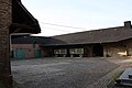
Today's townscape

Inner courtyard and residential building

Gateway to the store

2008 harvest
Square courtyard


The center of the place is the church of St. Pantaleon with its stately white tower, which towers high above the village and is a widely visible sign of Erps.
In addition, a large number of large and smaller farms characterize the townscape to this day, although only some of these farms are used for agriculture. Many stables, barns and sheds have now been converted into houses and apartments. The courtyard buildings usually date from the 18th or 19th century and were typically built with field fire bricks . A nice example of this is the Schleidenhof, a classic square courtyard in the middle of the village not far from the church , whose house dates back to 1746. Another example is the successor to the Velbrücker Hof, the Christinenhof, the oldest part of which was built in 1748.
Where the Raiffeisenbank building is today, the Laurentius Chapel used to stand right next to the Schleidenhof. It was demolished in 1838 because it was in disrepair and a school building was built in its place according to plans by the Schubert building council. In some rooms a preparatory was set up in the second half of the 19th century .
To the right and left of the Erpa, a green band of meadows and gardens runs through the town. The two oldest streets in town run parallel to Erpa, namely Luxemburger Straße (formerly Marktstraße) and Hochstraße (formerly Hundsstraße).
As in almost all places in the area, numerous new buildings - usually detached single-family houses - were built on the outskirts from the 1960s . The quite large old town center is still formative for the village.
Customs and clubs
Procession to Zülpich
The oldest written procession in Erftstadt, which has existed for over 500 years, is the procession from Erp to Zülpich that takes place every seven years.
Almost two decades after the Zülpich Marienbruderschaft founded in 1469, the first procession moved from Erp to Zülpich in 1488 to worship the painful Mother of God in the Marienkirche. The initiator was the vicar of the Laurentiuskapelle, Martin Raett, a co-founder of the Zülpich Marienbruderschaft. The procession started from the Laurentiuskapelle, called the "Klus". In that year the count's waiter gave a pair of "tortyssen" (wax torches) to the "Klus" for the first time for the procession, as was to happen every seven years from now on. In 1698 the procession was reorganized and new order of the procession was drawn up.
After the Laurentius Chapel was demolished, the procession moved from the parish church in Erp to Zülpich to the painful Mother of God, whose picture is now in St. Peter's Church in Zülpich.
Lately, due to the high volume of traffic on the public road on the way there, the procession was accompanied by the police; the return journey to Erp was made by bus.
Club life
Carnival , which was already extensively documented in the 19th century, is an integral part of life in Erp . The Carnival Society KG 111 organizes the "Session" every year with numerous events and the Rose Monday procession as the highlight. Another pillar of the Erper club system is the soccer club VfL (Verein für Leibesübungen) Erp from 1927/32, which took part in the main round of the DFB Cup in 1985 . In addition, there are numerous other clubs and groups such as the motorsport club, which has been active since 1976, the horticulture and beautification club, the St. Pantaleon church choir, the children's choir, car building associations, RSC (cycling club) Südwind Erp, etc. The Erftstadt model building association is also based in Erp the dance sport club Erftstadt. The traditional St. Sebastianus Shooting Brotherhood disbanded in 2016 due to a lack of young talent.
Erper dialect
A special feature is the Erper dialect with its rolling "R", which has been researched by Bonn University over a number of years and is the subject of an empirical study.

Architectural monuments
- The valuable Romanesque Erper Cross was acquired by Provincial Curator Paul Clemen and is now kept in the Diocesan Museum.
- Today only seven gravestones are left in the Jewish cemetery at Landstrasse 162. The Jewish burial ground in Erp has been owned by the Jewish Trust Corporation since 1952 .
Infrastructure
Erp has won several prizes in the competition Our village has a future (until 1997: Our village should be more beautiful) and has thus laid the foundation for a local, modest tourism.
traffic
Erp is on the B 265 , which connects it to Cologne via Lechenich and Liblar and to Trier via Zülpich. The location is served by a REVG bus line and a collective call taxi system in local public transport . The next connection points are Erftstadt at the A 1 / 61 and since 2011 Weilerswist West on the A1 . They are each 7 kilometers from the village.
education

Erp has a kindergarten , the St. Pantaleon day care center, with 75 places as well as a primary school , the Janusz Korczak School, which is attended by around 320 pupils from Erp, Friesheim, Niederberg and Borr. Secondary schools in Lechenich, Zülpich and Weilerswist can be reached by school bus. The parish has a library in the parish center.
politics
Cornelia Hütten ( CDU ) has been the local mayor since April 2020 .
In the last local election to the City Council of Erftstadt (2014), the following was elected in Erp:
| Political party | Number of votes |
|---|---|
| CDU | 536 |
| SPD | 293 |
| FDP | 96 |
| GREEN | 83 |
| FW | 37 |
Personalities
On the basis of the exchange contract of 1539, canons from the Steinfeld monastery worked as pastors in Erp for almost 300 years . Their work repeatedly prompted young men from Erp to enter the Steinfeld monastery. Two of them have gained importance far beyond the monastery:
- Johannes Horrichem was born in Erp in 1598. From 1631 he headed the Steinfeld Monastery as Abbot Norbert. As a close confidante of the then nuncio Fabio Chigi , who later became Pope Alexander VII , he advanced to become an influential church diplomat who, among other things, participated in the negotiations for the Peace of Westphalia .
- Stephan Horrichem , John's younger brother, was first canon of Steinfeld Abbey and then from 1635 to 1637 rector of the College of the Premonstratensian Order in Cologne. He then became prior of the Reichenstein monastery near Monschau , which he found in very poor condition and in which he brought religious life to a new bloom. During the Thirty Years' War he was helpful and tireless at the side of many persecuted people in the Monschau region. He died on August 12, 1686 and is revered as the "Apostle of the Venn " to this day. In his memory, the 6 meter high "Cross in the Fens" was erected near Monschau in 1890.
literature
- Albert Esser: The history of the village of Erp . 1969.
- Everhard Ismar: History of the parish and church St. Pantaleon Erp . Erp 1994
- Bernhard Schreiber: Archaeological finds and monuments of the urban area . Erftstadt 1999
- Karl Stommel : The French population lists from Erftstadt . City of Erftstadt 1989
- Karl and Hanna Stommel: Sources on the history of the city of Erftstadt Vol. 1–5. Erftstadt 1990–1998
- Hans Welters: Erp, an old village map tells . In: Home calendar of the Euskirchen district . 1955.
Web links
- District Erp. official website of the city of Erftstadt; Retrieved April 10, 2016
- Information about Erftstadt-Erp
Individual evidence
- ↑ erftstadt.de
- ↑ The future of lignite in selected areas, Neue Tagebaue:…, Erp-Irresheim, Environmental Policy Research Center of the Free University of Berlin, April 2008, p.1 ( page no longer available , search in web archives ) Info: The link was automatically marked as defective . Please check the link according to the instructions and then remove this notice. (PDF) 147 kB, accessed on March 26, 2010
- ↑ a b c Bernhard Schreiber: Archaeological finds and monuments of the Erftstadt area. Erftstadt 1999, pp. 130-132.
- ↑ a b c d e f Albert Esser: Erp. P. 12 ff
- ↑ HSTAD (Hauptstaatsarchiv Dusseldorf, today Landesarchiv NRW) stock Siegburg certificate no. 39; E. Wisplinghoff, Siegburg Document Book Volume I No. 50.
- ↑ HSTAD holdings Kurköln Lehen Spezialia 57, Certificate No. 1, and Norbert Andernach: Regesten der Archbishop von Köln im Mittelalter Volume XI Düsseldorf 1992 No. 498
- ↑ HSTAD inventory of Kurköln II 1916 pp. 10–12
- ↑ HSTAD inventory Kurköln II 1916, published in Stommel, Quellen Volume I No. 683
- ↑ HASTK (Historical Archive of the City of Cologne) Inventory Andreas certificate 1/251, published in Stommel, sources Volume I no. 682
- ↑ HASTK inventory Domstift files 15, published in Stommel, sources Volume V no. 2856
- ↑ a b HAStK inventory of St. Andreas files 22
- ↑ HSTAD inventory Kurköln II 1917 sheet 56, Kurköln II 1916 sheet 35–36 and Kurköln II 1915 sheet 3–5, published in Stommel, Quellen Volume III No. 1786, No. 1789, No. 1981, No. 2016
- ↑ HSTAD holdings Kurköln Lehen Spezialia 57, certificate No. 8
- ↑ HSTAD inventory Kurköln II 1921, published in Stommel Quellen Volume IV No. 2144
- ↑ HSTAD Lehen Spezialia 57 acts / 1 sheet 1-37, published in Stommel, sources Band IV no. 2192
- ↑ HSTAD inventory Kurköln Lehen Spezialia 57, certificate No. 9
- ↑ Herzoglich Croy'sches Archiv Dülmen Department 2 Erp files 2a
- ^ Archives Dülmen, Department 2 Erp, files 2a
- ↑ Dülmen archive department 2 Erp, certificate in files 2b and HSTAD inventory Kurköln II 1152
- ↑ Dülmen archive department 2 Erp files 2c
- ↑ a b HSTAD inventory Herrschaft Manderscheid 137, published in Stommel, Sources Volume IV No. 2847
- ↑ Dülmen archive department 2 Erp files 2d
- ↑ HSTAD deposit Cologne files 216, published in Stommel, sources Volume II 1085
- ↑ HSTAD inventory rule Manderscheid 137, published in Stommel, sources Volume III no. 570 (Supplement)
- ↑ HSTAD inventory Electorate of Cologne II in 1916, published in Stommel, sources Volume III no. 1865
- ↑ HSTAD inventory Kurköln II 1918, sheet 3–38, published in Stommel, Quellen Volume IV No. 2173
- ↑ HSTAD inventory rule Manderscheid 137 and inventory Electorate of Cologne XIII 157-159, published in Stommel, sources Volume IV no. 2553 and Volume V no. 2841
- ↑ Dülmen archive, department 2 Erp files 2b and HAStK inventory St. Georg files 16, published in Stommel, sources volume V No. 2883
- ↑ HAStK inventory of the Carmelites in Kupfergasse files 7 and 8
- ↑ HSTAD inventory Electorate of Cologne II in 1921, published in Stommel, sources Volume IV no. 2144
- ↑ Dülmen archive department 2 Erp files 2a, 2d, 2e and HSTAD inventory Herrschaft Manderscheid 137, published in Stommel, sources II No. 964a
- ↑ HSTAD inventory of Kurköln II 1918
- ↑ HSTAD inventory Kurköln II 1152
- ↑ HSTAD inventory of Kloster Hoven Akten 3, published in Stommel, Quellen Volume III No. 1810
- ↑ Dülmen archive, department 2 Erp files 2d, published in Stommel, sources Volume IV No. 2049
- ↑ HSTAD inventory rule Manderscheid 136
- ↑ HSTAD inventory Kurköln IV 2499
- ^ Dülmen archive, department 2 Erp files 2d and archive Schloss Gracht files 51, files 23 and 24 (troop marches), published in Stommel, sources vol. V no. 2675 and no. 2679
- ^ Karl Stommel: The French population lists from Erftstadt . Erftstadt 1989, pp. 111–152
- ↑ W. Schieder (Ed.): Secularization and Mediatization in the four Rhenish departments, Canton Lechenich , pp. 468-470
- ↑ Martin Bünermann: The communities of the first reorganization program in North Rhine-Westphalia . Deutscher Gemeindeverlag, Cologne 1970, p. 86 .
- ↑ to Ismar
- ↑ to Ismar
- ↑ to the Mayer website
- ↑ to Ismar
- ↑ Dieter Kastner, Parish Archives St. Peter Zülpich No. 19
- ↑ HSTAD Herrschaft Manderscheid 137, therein waiter's bill from 1488
- ↑ Erp gets bronze ( page no longer available , search in web archives ) Info: The link was automatically marked as defective. Please check the link according to the instructions and then remove this notice. KSTA.de, created: September 15, 2009
Coordinates: 50 ° 46 ' N , 6 ° 43' E

Ahrem | Blessem with Frauenthal | Bliesheim | Borr / Scheuren | Dirmerzheim | Erp | Friesheim | Gymnich with Mellerhöfe | Gorgeous | Kierdorf | Köttingen | Lechenich with Konradsheim | Liblar | Niederberg