
Lahnsattel (municipality of St. Aegyd)
|
Lahnsattel ( Rotte ) village |
|||
|---|---|---|---|
|
|||
| Basic data | |||
| Pole. District , state | Lilienfeld (LF), Lower Austria | ||
| Judicial district | Lily field | ||
| Pole. local community | St. Aegyd am Neuwalde ( KG rule reasons ) | ||
| Coordinates | 47 ° 46 '21 " N , 15 ° 30' 26" E | ||
| height | 938 m above sea level A. | ||
| Residents of the village | 65 (January 1, 2020) | ||
| Building status | 83 (2001) | ||
| Post Code | 8694 Frein an der Mürz | ||
| Statistical identification | |||
| Locality code | 04445 | ||
| Counting district / district | St.Aegyd area (31411 001) | ||
| Place i. e. P. 23 Adr. (2015); Address range 38 Adr. (2015) Source: STAT : Local directory ; BEV : GEONAM ; NÖGIS |
|||

Lahnsattel is a place in the Mürz Valley in Lower Austria as well as a locality and cadastral community of the municipality of St. Aegyd am Neuwalde in the Lilienfeld district .
geography
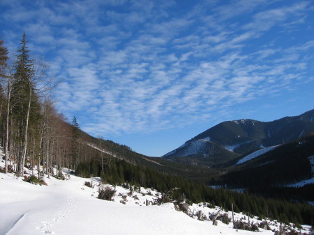
The location is 27½ kilometers southwest of Lilienfeld and 23 kilometers northwest of Mürzzuschlag . It is located on the Lahnsattel ( 1006 m above sea level ), the pass between the uppermost Mürz Valley near Frein an der Mürz and the uppermost Salzatal near Mariazell - Halltal , at the southern foot of the Göller ( 1766 m above sea level ). South rises the 1523 m above sea level. A. high Wildalpe . Both mountains belong to the Mürzsteg Alps , respectively the Göller to the Lower Austrian Limestone Alps and the Wildalpe to the Hochschwab group of the Upper Styrian Limestone and Slate Alps .
Place and village Lahnsattel
The Rotte Lahnsattel is about a kilometer east of the pass at about 940 m above sea level. A. on the Mürz Valley side of the saddle, directly on the Styrian border. The place comprises almost 25 buildings along Lahnsattel Straße (B23).
The location in the broader sense (address area) also includes the Rotte Donaudörfl below, out of the valley the house near Kaltwagl , and also the abandoned location Gscheidl on the Gscheidlhöhe to Schwarzau east, together around 40 addresses.
The village of Lahnsattel also includes the Rotte Neuwald Mürzalauswärts, as well as the village of Terz on the other side of the Lahnsattel an der Salza (of which houses also belong to Mariazell), as well as the Göllerhaus . That is a total of 80 buildings with a little over 100 inhabitants.
The place Lahnsattel is about 50 meters above the Kriegskoglbach , in the south of the place the terrain is flat, in the north and east some ditches run down from the south flank of the Göller, the Lahngraben and at Donaudörfl Hintereck- and Saugraben . The latter goes up to the Waldhütsattel ( 1266 m above sea level ) between Göller and Gippel massif ( 1699 m above sea level ), where it then goes left to the Göllerhaus, on the other side down to Kernhof . Stille Mürz (von Gscheidl) and Kalte Mürz zur Mürz come together between Kaltwagl and Neuwald .
Lahnsattel forms an orographic exclave to the main town of St. Aegyd , 10 kilometers northwest of the Göller-Gippel-Zug , which can only be reached via the two passes Kernhofer Gscheid (Salza area) - Lahnsattel (Mürz area) around the Göller, a good 20 kilometers by road. The borders to the Styrian localities arise from the fact that the state border and thus also the St. Aegyder municipality border runs along the brooks. Due to its remote location, the place also has a Styrian postcode (8 ...).
Neighboring towns and cities

|
Ulreichsberg (O)
Gscheid ∗
|
Göller |
Kernhof (O) |
|
Terz (Gem. St. Aegyd aNu Mariazell ) |
.svg)
|
|
| (both districts Bruck-Mürzzuschlag , Styria ) | Frein an der Mürz (O, Gem. Mürzsteg ) |
- ∗ Gscheid still belongs to the village of Kernhof
History and sights
The reasons for rule were an old sovereign hunting ban , one of the largest Dominical possessions in Austria at the time. From the fact that it was a forest management, the course of the administrative boundaries in the valleys comes from.
Woodwork began here in 1783, before that the area was completely uninhabited and there was only one house in Terz . The first houses on Lahnsattel were built in the 1780s. The cleaning master Georg Huebmer (Hubmer) , the "Raxkönig", had started at that time to sell wood on a large scale to the Innerberg Main Union and then to Vienna in Hoyos 's Schwarzau . When the forests of the Naßwald area were exhausted, Huebmer had to move to more and more distant forests in the Mürz catchment area. In the 1810s, he received imperial permission to flog here in the ruling forest.
The timber entrepreneur, who was born in Gosau am Dachstein, in the Salzkammergut , then brought a closed group of lumberjacks from his hometown to him and settled them in Lahnsattel and Ulreichsberg . At the end of this settlement the place comprised 25 chaste and 130 inhabitants. The Gosauers had long been secret Protestants who were only able to move freely thanks to the Josephine Tolerance Patent of 1781, and were then sought after as good forest workers. The Salzkammergut people settled on the Lahnsattel, while later Catholic people, including those from the Danube valley who were damaged by the floods in 1830 , founded the Donaudörfl . Also on the Gscheidlhöhe, where Huebmer had a flood tunnel blown into the Schwarzau region and built a wooden elevator, a small village, Gscheidl , with a school and an inn was built at the time .
The cultural differences between the two places persisted for a long time. The Protestant Holzknecht families only addressed each other by their baptismal name as a sign of togetherness, the Donaudörflers were addressed by their family name. The small, secluded local cemetery of the Lahnsattler is still worth seeing, while the Donaudörfler and Neuwalder were parish off to Frein .
In the late 19th century, Emperor Franz Joseph promoted pilgrimages to Mariazell , and the Alpine Association marked the Zellersteig Gscheidlhöhe - Lahnsattel in 1893 , but at that time it was still strictly forbidden to leave the path. Today, the eastern branch of the Austrian long-distance hiking trail 06, the Mariazellerweg , leads over Lahnsattel .
The end of the forest work came after the First World War, at that time the village of Gscheidl was gradually abandoned, and the village around the Lahnsattel has since been affected by strong emigration: In 1910 more than 370 people lived here, the population fell below 200 in the 1960s , and is now only around 100. In the last 20 years it has lost almost a fifth of its population.
Only a remnant remains of the former primeval forest on the Gscheidl, the Neuwald , known as the Lahnsattler primeval forest . Otherwise the area on the Silent Mürz is today forest without any special features.
The Lahngraben, and with it the saddle and place, got its name from the frequent avalanche tracks ( Lahn in dialect ). The Lahnsattel bears its name not without good reason, the region has snowy winters and the location is often affected by avalanches. On January 17, 1844, a dust avalanche buried two houses with a total of eleven people. After three days a woman was found alive. On January 18, 1878, a 150-meter-wide avalanche fell from the Göller, killing 13 people and causing the Höchbauernhaus restaurant on the saddle to disappear without a trace. To this day, Lahnsattelstrasse is often closed due to the danger of avalanches.
The place is a good starting point for climbing the Göller, on which a number of different levels of difficulty are possible.
The Kaltenbachloch , a spring cave, is right next to the village .
Personalities
The Fasching family Maria, Mitzi and Fritz Fasching were recognized as Righteous Among the Nations in 1991 by the Yad Vashem Holocaust Memorial
| EHzgt. Austrian |
Krld. Austrian udEnns ( Austria- Ugrn. ) |
Bld. Lower Austria ( 1st / 2nd Rep. Austria ) |
|||||||||||
| 1751 | 1869 | 1880 | 1890 | 1900 | 1910 | 1923 | 1951 | 1961 | 1971 | 1981 | 1991 | 2001 | 2011 |
|---|---|---|---|---|---|---|---|---|---|---|---|---|---|
| - | 385 | 342 | 311 | 290 | 376 | 347 | 252 | 210 | 176 | 163 | 123 | 105 | |
| 1 | 59 | 53 | 50 | 49 | 55 | 56 | 62 | 62 | 72 | 78 | 79 | 83 | 86 |
Web links
- 31411 - St. Aegyd am Neuwalde. Community data, Statistics Austria .
Individual evidence
- ↑ a b The only house in Gscheidl has the addresses Kernhof; the settlement is not to be confused with the location Gscheid on the Kernhofer Gscheid northwest.
- ↑ Heiner Eichner, Otto Back, Peter Ernst, Sergios Katsikas: Language standardization and language planning. Festschrift for Otto Back on his 70th birthday; with articles from the fields of graphematics, orthography, onomatology, Austrian German, language standardization and planned language studies, 2nd edition, Verlag Edition Praesens, 1996, p. 161 f.
-
↑ a b c Kurt Klein (edit.): Historical local dictionary . Statistical documentation on population and settlement history. Ed .: Vienna Institute of Demography [VID] d. Austrian Academy of Sciences . Lower Austria Part 2, St. Aegyd am Neuwalde: Lahnsattel
, p.
122 ( online document , explanations . Suppl . ; both PDF - oD [updated]). Special references: 1751: Theresian versions . Lower Austrian Provincial Archives (NÖLA), State Archives . Information based on the Weigl estate in the NÖLA. • 1869: Statistische Central-Commission (Hrsg.): Local repertories of the kingdoms and countries represented in the Austrian Imperial Council . (1871 ff.). • 1880, 1890: Statistical Central Commission: Special local repertories of the kingdoms and countries represented in the Austrian Imperial Council . 1883 resp. 1892 ff. • 1900: Central Statistical Commission: Community lexicon of the kingdoms and countries represented in the Imperial Council . 1903 ff. • 1910: Statistical Central Commission: Special Repertories . 1915 ff. • 1923 and later: Federal Statistical Office / Austrian Central Statistical Office / Statistics Austria (ed.): Directory of places . (Results of the census).
- ↑ a b Fritz v. Neuman (arrangement), Kurt Bellak (ed.): Local history of the Lilienfeld district. Volume 4. 2nd edition. Bezirksheimatmuseum Lilienfeld, Lilienfeld 2002, p. 32. According to Klein, p. 122
- ^ Fritz Lange: From Dachstein to Rax - In the footsteps of Georg Hubmer. Sutton Verlag, 2007, ISBN 978-3-86680-184-4 ( limited preview in Google book search).
- ↑ a b story. staegyd.at.
- ↑ Lange, 2007, photo p. 96, and p. 101.
- ^ Franz F. Seidl: Mürzsteg in the course of time. Verlag der Gemeinde, 1995, Ortschaft Neuwald , p. 623 ff., Donaudörfl , p. 625.
- ↑ Mitteilungen des Deutschen und Oesterreichischen Alpenverein , Volume 19, 1893, p. 154, column 2 ( limited preview in the Google book search).
- ↑ The Neuwald is different from the Rothwald (which had a similar orographic exclave location) because it is freely accessible, not a real primeval forest in the sense of a nature reserve. In detail in K. Zukrigl, G. Eckhart, J. Nather: Locational and silvicultural investigations in primeval forest remnants of the Lower Austrian Limestone Alps. = Notices from the Federal Forest Research Institute Mariabrunn 62, 1963, p. 9
- ↑ See photo, Martin Nessl, 2009, for the tour description, martinnessl.info
- ^ [1] Yad Vashem.

Cadastral communities: Gscheid | Reasons for rule | Keeramt | Mitterbachamt | St. Aegyd am Neuwalde | Wrong Traisen | Weißenbachamt
Locations: Kernhof | Lahnsattel | Mitterbach | St. Aegyd am Neuwalde | Ulreichsberg
Market place: St. Aegyd am Neuwalde | Villages: Eisenwerk • Kernhof | Weiler: Tobiasl • In the Walk | Rotten: Donaudörfl • Fadental • Gscheidl • Lahnsattel • Neuwald • Obermitterbach • Terz • Ulreichsberg • Untermitterbach | Settlements: Croatian village • Parish settlement | Scattered houses: Gscheid • Mitterbach • Rotenbach • Rubesfang • Seebach • Unrechttraisen • Wällischgraben • Weißenbach | Other local materials: On the main Traisen • Göller House • Gscheid inn • Hoyossiedlung • Kaltwagl • Krumbach • Mitterbach Office • Oberkeer • Upper Knoll neck • Michelbühel • Sattelhof • On Seebach • Under Knoll neck • Unrechttraisen Office • Walkmühle • Zdarskyhütte
Counting district: St.Aegyd central area | St.Aegyd area