
Langendonker Mill (Geldern)
| Langendonker Mill (Geldern)
|
||
|---|---|---|
 Castle ruins of Haus Langendonk |
||
| Location and history | ||
|
||
| Coordinates | 51 ° 31 '47 " N , 6 ° 23' 24" E | |
| Location | Germany | |
| Waters | Issumer Fleuth | |
| Built | before 1442 | |
| Shut down | 2nd half of the 19th century | |
| technology | ||
| use | Flour mill | |
| Grinder | 1 grind | |
| drive | Watermill | |
| water wheel | undershot | |

The Langendonker Mühle was a watermill located on the Issumer Fleuth in the city of Geldern with an undershot water wheel .
geography
The Langendonker Mühle was located on Issumer Fleuth, Aengenesch Langendonker Weg, in the Kapellen district , in the city of Geldern, in the Kleve district , in North Rhine-Westphalia .
The Issumer Fleuth has a height of approx. 22 m above sea level here . The care and maintenance of the water is the responsibility of the Niersverband , which is based in Viersen .
history
The Langendonk mill belonged to the Langendonk House, first mentioned in 1391 . In 1442 the mill was the subject of a declaration by Heinrich von Alpen, who confessed that he had received it as a fief from Count Friedrich IV von Moers . It is known from 1828 that the grain mill was operated with only one grinding cycle and, like all mills on the Fleuth, was without work in summer due to lack of water. This was then taken over by windmills . In the second half of the 19th century, the mill probably went under for the reasons mentioned above.
gallery

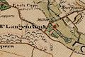
Langendonker Mühle on the new record in 1892
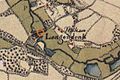
Langendonker Mühle on the original cadastral map 1844
Langendonker Mühle on the 1802 tranchot card


literature
- Hans Vogt: Lower Rhine water mill guide. 2nd Edition. Niederrhein Association, Krefeld 1998, ISBN 3-00-002906-0 .
- Susanne Sommer: Mills on the Lower Rhine . Rheinland Verlag, Cologne 1991, ISBN 3-7927-1113-3 .
Web links
Individual evidence
On the Niers :
old oil mill Geldern |
Old Wylick Mill |
Aspermühle |
Bimmen mill |
Castle mill Geldern |
Höster mill |
Holtheyder Oil Mill |
Goch grain mill |
Corn mill house Caen |
Corn mill Wachtendonk |
Lohmühle Goch |
Lohmühle Wachtendonk |
Mill on the Fleuth |
Mills from Haus Gesselen |
Neumühle |
Niersmühle Weeze |
Oil mill Goch |
Oil mill house Caen |
Wachtendonk oil mill |
Oil mill knowledge |
Ponter Mill |
Sawmill knowledge |
Castle mill knowledge |
Schravelsche Mühle |
Susmühle |
Vlassrather grain and oil mill |
Viller Mill |
Fulling Mill Goch |
Fulling Mill House Caen |
Fulling Mill Knowledge |
Fulling mill and oil mill Geldern |
Willick's Mill |
Windvonderer Mühle
An der Nette :
Kovermühle |
Nettmühle |
Vorster Mühle
Am Leitgraben / Mühlengraben :
Vennmühle Straelen |
Paesmühle |
Maesemühle
An der Gelderner Fleuth :
Pletzmühle |
Wyemühle
An der Issumer Fleuth :
Langendonker Mühle |
Kapellener Mill |
Honselaerer Mühle
At the Kervenheimer Mühlenfleuth :
Fallmühle |
Kervenheimer Mühle
An der Kendel :
Yshövelsche Mühle |
Mill to garbage