Lopatino (Pensa, Lopatinski)
| Village
Lopatino
Lopatino
|
||||||||||||||||||||||||||||||||||||
|
||||||||||||||||||||||||||||||||||||
|
||||||||||||||||||||||||||||||||||||
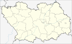
Lopatino ( Russian Лопа́тино ) is a village (selo) in the Penza Oblast in Russia with 4,392 inhabitants (as of October 14, 2010).
geography
The place is located on the Volga plateau a good 80 km as the crow flies southeast of the administrative center of Penza . It is located on the left bank of the Sura left tributary, Usa .
Lopatino is the administrative center of Lopatinski Rajon and the seat of the rural community (selskoje posselenije) Lopatinski selsowet, which also includes the six villages Bolshaya Bagrejewka, Budjonnowka, Dym-Tschardym (respectively 9, 14 and 12 km west), Generalschtschino, Jelschanka and Nikolajewka (corresponding to 11 , 4 and 3 km southeast) as well as the three settlements (possjolok) Borez (north then on the other bank of the river), Mayak (4 km northeast) and Wladimirski (9 km west) belong.
history
The village was founded around 1717/1718 and was already listed as an important town on a map of the region in 1730. An early alternative name as Novo-Lopatino ("New Lopatino") suggests that it was founded by resettlers from one of the larger number of other villages of this name, probably from Lopatino near Gorodishche, about 50 km north . Until the end of the 19th century, Nikolskoje, after the name of the village church, was used as a further name .
From 1780 Lopatino belonged to the Ujesd Petrowsk of the Saratov governorate, from December 1796 to March 1797 briefly to the then temporarily disbanded Penza Governorate and then to the Saratov Governorate . In the 1870s it became the seat of a Volost. On July 23, 1928, Lopatino became the administrative seat of a Rajons newly created from the enlarged Volost. This was in the meantime dissolved from 1963 to 1965, and its territory was annexed to the Shemyscheiski rajon.
Population development
| year | Residents |
|---|---|
| 1897 | 2398 |
| 1939 | 2431 |
| 1959 | 2230 |
| 1970 | 2222 |
| 1979 | 3441 |
| 1989 | 4759 |
| 2002 | 4376 |
| 2010 | 4392 |
Note: census data
traffic
By Lopatino the regional road leads (on their part in Lopatinski rayon called 58K-160), the 50-km to the north in Nischnjaja Jeljusan on the federal highway M5 Ural begins by the north-east of neighboring Rajonverwaltungszentrum Russki Kameschkir and on to Petrowsk in Saratov Oblast leads where it reaches federal highway R158 from Nizhny Novgorod - Saransk - Penza - Saratov . In a north-westerly direction there is a connection to the Penza Oblast center (in the Rajon as 58K-342) via the neighboring district center of Shemysheika ; to the west the 58N-158 also leads to the R158 and further as 58К-181 to the neighboring district center of Malaja Serdoba .
The nearest train station is a good 40 km southwest in Petrovsk on the Atkarsk - Sennaya line .
Web links
Individual evidence
- ↑ a b Itogi Vserossijskoj perepisi naselenija 2010 goda. Tom 1. Čislennostʹ i razmeščenie naselenija (Results of the All-Russian Census 2010. Volume 1. Number and distribution of the population). Tables 5 , pp. 12-209; 11 , pp. 312–979 (download from the website of the Federal Service for State Statistics of the Russian Federation)


