Shemysheika
| Urban-type settlement
Shemysheika
ыемышейка
|
||||||||||||||||||||||||||||||||||
|
||||||||||||||||||||||||||||||||||
|
||||||||||||||||||||||||||||||||||
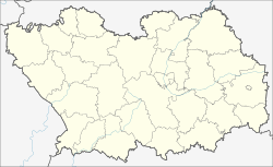
Schemysheika ( Russian Шемыше́йка ) is an urban-type settlement in the Penza Oblast in Russia with 6512 inhabitants (as of October 14, 2010).
geography
The place is about 40 km in a straight line to the southeast of Oblastverwaltungszentrums Pensa on the left Sura creek Usa , the few kilometers to the northwest in the Sura Reservoir (Surskoje wodochranilischtsche) opens.
Schemyscheika is the administrative center of the Rajons Schemyscheiski and seat of the municipality (gorodskoje posselenije) Rabotchi possjolok Schemyscheika, also (6 km east) belong to the village Mordowskaja Norka (6 km southeast) and the settlement Lesnoi.
history
The place was first mentioned in a document in 1705 as a newly built village Nikolskaja (Schemischeika) with 15 courtyards. From 1780 it belonged to the Ujesd Kuznetsk governorship, later Saratov governorate . The name Nikolskoje, after the patron saint of the village church, was used as an alternative designation until the early 20th century.
On February 10, 1932, the administrative headquarters of the Naskaftymski rajon, founded on July 16, 1928, with its seat in the village of Naskaftym , located just under 20 km northeast, was relocated to Shemysheika and the raion was renamed accordingly. In the 1980s, the place received the status of an urban-type settlement.
Population development
| year | Residents |
|---|---|
| 1795 | 760 |
| 1859 | 2553 |
| 1897 | 3059 |
| 1939 | 2737 |
| 1959 | 2569 |
| 1970 | 2914 |
| 1979 | 5532 |
| 1989 | 6806 |
| 2002 | 6708 |
| 2010 | 6512 |
Note: from 1897 census data
traffic
Regional road 56K-161 runs through Schemyscheika from Penza to the neighboring district of Lopatino in the southeast . To the west, the 56K-276 branches off to the village of Kondol, about 25 km away , on the federal highway R158 Nizhny Novgorod - Penza - Saratov . In the northeast 56K 59 proceeds according Gorodishtche , via which the approximately 30 km away from the nearest station Kanajewka (near Sursk ) at the track Ryazhsk - Pensa - Sysran is achievable.
Web links
Individual evidence
- ↑ a b Itogi Vserossijskoj perepisi naselenija 2010 goda. Tom 1. Čislennostʹ i razmeščenie naselenija (Results of the All-Russian Census 2010. Volume 1. Number and distribution of the population). Tables 5 , pp. 12-209; 11 , pp. 312–979 (download from the website of the Federal Service for State Statistics of the Russian Federation)


