Patschelma
| Urban-type settlement
Patschelma
Пачелма
|
||||||||||||||||||||||||||||||||||
|
||||||||||||||||||||||||||||||||||
|
||||||||||||||||||||||||||||||||||
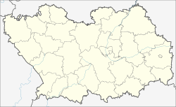
Patschelma ( Russian Па́челма ) is an urban-type settlement in the Penza Oblast in Russia with 8053 inhabitants (as of October 14, 2010).
geography
The place is good 110 km in a straight line to the west of Oblastverwaltungszentrums Penza , near the river Patschelma, a right tributary of the upper reaches of Worona .
Patschelma is the administrative center of Patschelmski Rajon and the seat and only locality of the municipality (gorodskoje posselenije) Rabotschi possjolok Patschelma.
history
The settlement was established in 1874 in connection with the opening of the Morshansk - Pensa - Syzran railway around a station named after the river there.
On July 16, 1928, Patschelma became the administrative seat of a newly created Rajons named after him. In 1948 the place received the status of an urban-type settlement.
Population development
| year | Residents |
|---|---|
| 1897 | 536 |
| 1926 | 4.025 |
| 1939 | 5,787 |
| 1959 | 10,928 |
| 1970 | 8.233 |
| 1979 | 9.113 |
| 1989 | 9,466 |
| 2002 | 8,735 |
| 2010 | 8,053 |
Note: census data
traffic
Patschelma has a train station at kilometer 565 of the railway line ( Moscow -) Ryashsk - Penza - Syzran, opened in 1874 .
The settlement is located on the regional road 58K-360, which leads from Nizhny Lomow, 30 km to the northeast, on the M5 Ural Moscow - Chelyabinsk to the neighboring district of Bashmakowo to the southwest . In a south-easterly direction there is the 58K-296 connection to the city of Kamenka, 50 km south-east, on the federal trunk road R208 Tambow - Belinski - Pensa.
Web links
Individual evidence
- ↑ a b Itogi Vserossijskoj perepisi naselenija 2010 goda. Tom 1. Čislennostʹ i razmeščenie naselenija (Results of the All-Russian Census 2010. Volume 1. Number and distribution of the population). Tables 5 , pp. 12-209; 11 , pp. 312–979 (download from the website of the Federal Service for State Statistics of the Russian Federation)


