
Mareuil (Dordogne)
| Mareuil | ||
|---|---|---|
.svg)
|
|
|
| local community | Mareuil en Périgord | |
| region | Nouvelle-Aquitaine | |
| Department | Dordogne | |
| Arrondissement | Nontron | |
| Coordinates | 45 ° 27 ' N , 0 ° 27' E | |
| Post Code | 24340 | |
| Former INSEE code | 24253 | |
| Incorporation | January 1, 2017 | |
| status | Commune déléguée | |
.JPG) Château de Mareuil from the 16th century |
||

Mareuil , or Mareuil-sur-Belle ( Occitan Maruelh ) is a town and commune Déléguée in the French commune of Mareuil en Périgord with 961 inhabitants (as of January 1 2017) of the North West department Dordogne in the region Nouvelle-Aquitaine . The area of the Commune déléguée is part of the Périgord-Limousin Regional Nature Park .
geography
Mareuil is located in the Périgord , halfway between Périgueux and Angoulême , about 35 kilometers from the two major cities. Mareuil was surrounded by the following parishes:
- Puyrenier in the north.
- Saint-Sulpice-de-Mareuil in the northeast.
- Vieux-Mareuil to the east and south-east.
- La Chapelle-Montabourlet in the south.
- Gout-Rossignol in the southwest.
- Sainte-Croix-de-Mareuil to the west and north-west.
The municipality of Mareuil had the most inhabitants in the canton of Mareuil, and it had the highest population density. The following localities, castles, hamlets and farms belong to the relatively large area of the Commune déléguée:
Beauclaveau , Beaugarie , Champeyroux , Château de Beaulieu , Château de Beauregard , Chez Buisson , Chez Ciermont , Chez Gayet , Chez Maillé , Chez Marot , Chez Prougnac , Colombières , Font-Grand , Gabardeau , L'Âge , L'Epéronias , La Becquerie , La Bregère , La Gare , La Gauterie , La Grange du Moreau , La Maurelie , La Picherie , La Valade , Le Breuil , Le Chavan , Le Maine Rangé , Le Mandagat , Le Petit Breuil , Le Repaire , Le Thévou , Les Maines , Les Plagnes , Lespinasse , Malignac , Montbreton , Pareillas , Piovit , Ringaud , Rocfiat , Saint-Laurent , Saint-Pardoux , Saint-Priest , Tivoli and Villard .
The area of the Commune déléguée is traversed by the Belle , a left tributary of the Lizonne , in a NW-SE direction, drainage is to the northwest.
The topographically lowest point at 105 meters above sea level is located in the northwest on the Belle, near the hamlet of Chez Maillé . The highest point at 207 meters is in the extreme northeast near the D 708. At le Chavan in the southwest, 194 meters are reached. Mareuil is therefore in a lowland between a ridge running in the northeast and a ridge in the southwest.
geology

The geological underground of Mareuil is completely formed by sediments from the northern Aquitaine Basin . The area of the Commune déléguée lies on the southeast flank of the NW-SE-trending Mareuil anticline , a slightly asymmetrical, northeast-verging bulge in the sedimentary cover of the Aquitaine Basin. The oldest exposed rocks are cryptocrystalline limestone of the Kimmeridgian in the extreme northeast. A long hiatus is followed by a transgressive cenomanium on which Mareuil was built. The cenomanium consists of gray-green, oyster- bearing marls and sandy alveoline limestones . Above it is concordant Turonium with the Ligérien and Angoumien ( Rudistenkalke ). In contrast to the more or less flat formations, it shows some slight tilts caused by tectonics . The Turonium is followed by the Coniacium , which consists of quite hard fossil limestone . The sequence of layers is completed by chalky, partly glauconite-containing santonium , which has only survived on the north-eastern ridge. Another tectonic peculiarity is a NW-SE trending fault , running parallel to the anticline ( Mareuil fault ), which extends from La Rochebeaucourt to north of Brantôme and is in direct genetic connection with the movements at the anticline. This is a postponement with an offset of around 30 meters, with the southwest half being raised. The chalk formations are then covered in the extreme northeast by Young Pleistocene colluvium, consisting of Alterites of the Santons.
history
The oldest historical evidence in Mareuil goes back to the Middle Ages . The nobleman Guillaume I von Mareuil was first mentioned in a document in 1099. The oldest buildings in the municipality of Mareuil are the Romanesque churches of Saint-Pardoux , of Saint-Priest (12th century) and the church of Saint-Laurent of Mareuil, also from the 12th century. The two châteaus (Beaulieu and Beauregard) date back to the 15th century. The Château de Mareuil was built in the 16th century.
In 1827, the formerly independent municipalities of Saint-Pardoux-de-Mareuil and Saint-Priest-de-Mareuil merged with Mareuil.
The municipality of Mareuil became with effect from January 1, 2017 with the municipalities of Champeaux-et-la-Chapelle-Pommier , Les Graulges , Léguillac-de-Cercles , Beaussac , Monsec , Puyrenier , Saint-Sulpice-de-Mareuil and Vieux-Mareuil merged to form the Commune nouvelle Mareuil en Périgord and has since had the status of a Commune déléguée there. It was the capital of the canton of Mareuil until its dissolution in March 2015 and then belonged to the canton of Brantôme
administration
The mayor of Mareuil had been Alain Ouiste, a non-party member since 2005.
Population development of the former
| Population development in Mareuil | ||||
|---|---|---|---|---|
| year | Residents |

|
||
| 1962 | 1137 | |||
| 1968 | 1103 | |||
| 1975 | 1209 | |||
| 1982 | 1210 | |||
| 1990 | 1194 | |||
| 1999 | 1113 | |||
| 2007 | 1130 | |||
| 2016 | 1002 | |||
Source: INSEE
The population statistics for Mareuil go back to 1793. The absolute high point in the population was the year 1851 with 1837 inhabitants. A second maximum was in 1886 with 1616 inhabitants. At the turn of the 20th century, there was a sharp decline. The population development was relatively stable again from the 1960s. The strong age-bias and the predominance of the female population are striking; For example, those over 60 make up 38.4% of the total population of Mareuil and 54.8% of the total population are female.
Attractions
.JPG)
The following attractions are located in the municipality of Mareuil:
- Château de Beaulieu from the 15th and 18th centuries, registered as a monument historique .
- Château de Beauregard , 15th, 16th and 17th centuries, also a monument historique.
- Château de Mareuil from the 16th century, monument historique.
- Romanesque church of Saint-Pardoux , monument historique.
- Church ruins of Saint-Priest from the 12th century, monument historique.
- Saint-Laurent church in Mareuil from the 12th century. The Gothic style church was expanded in the 15th and 16th centuries. The entrance portal is from the Renaissance .
Transport links
In addition to the main traffic artery D 939, Mareuil is crossed in NE-SW direction by the D 708 coming from Nontron to Ribérac , and in the NS direction the D 99 from Les Graulges to La Tour-Blanche crosses .
Mareuil used to have a train station and could be reached from Ribérac by rail. The line has been shut down for a long time. The line then continued via La Rochebeaucourt and Rougnac towards Angoulême.
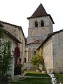
The church of
Saint-Pardoux
Sarcophagi carved from Angoumia in Saint-Pardoux
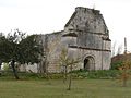
The ruined church of
Saint-Priest
The
Château de Beaulieu


.JPG)