
Martinsturm (Klingenmünster)
| Martinsturm | ||
|---|---|---|
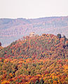
 The Martinsturm on the Treutelsberg |
||
| Data | ||
| place | Klingenmünster | |
| builder | Peter Meisel | |
| architect | Ing.Heinrich Kling | |
| Client | Klingenmünster District Insane Asylum | |
| Construction year | 1886 | |
| height | 14 m | |
| Floor space | 9.62 m² | |
| Coordinates | 49 ° 9 '8.4 " N , 7 ° 59' 21.4" E | |
|
||
| particularities | ||
| Observation tower; comprehensive panoramic view | ||

The Martinsturm is a 14 m high observation tower near the Palatinate municipality of Klingenmünster ( Rhineland-Palatinate ). The tower on the 503.7 m above sea level. NHN high Treutelsberg was from 1886 sandstone built and extensively renovated in the 1990s. It is a listed building and is one of the cultural monuments of Klingenmünster . Previously, he also served as the forest fire protection, today he alone tourist importance. With good visibility, the panorama extends to the Odenwald , the Black Forest and the Vosges .
Geographical location
The Martinsturm is located about 2.5 km northwest of the wine-growing community of Klingenmünster. The Treutelsberg, a tripartite cone ridge mountain , carries the observation tower on its highest summit, which is also called Treutelskopf . The mountain is part of the eastern edge of the Palatinate Forest , which separates the mountains from the Rhine plain . At the same time it belongs to the Wasgau , a low mountain range that crosses the German- French border and is formed by the southern Palatinate Forest and the northern Vosges . Striking geographical boundaries of the area are the Rhine plain in the east and the valleys of the Kling and Kaiserbach in the south and north . In contrast, to the west of the Treutelsberg there is a rather gradual transition to the leveled areas around the local communities of Völkersweiler and Gossersweiler-Stein .
Building history
The information on the planning and construction of the tower differs slightly in various sources.
In the early summer of 1886, the director Ferdinand Karrer of the Klingenmünster District Insane Asylum and the Royal Forestry Office in Annweiler discussed the plan to build a "beautification tower" on the Treutelsberg. In August 1886 the building contractor Peter Meisel from Klingenmünster received the contract for the construction, which was carried out within three months under the supervision of the engineer and architect Heinrich Kling from Landau . The two wealthy brothers of a patient named Martin Waldthausen, who was treated for a long time in the mental hospital and lived there, took over the financing of the construction costs of 800 marks. The inauguration of the tower took place on November 11, 1886, the patient's name day . For the inauguration ceremony, the Waldthausen family donated another 200 marks, which were used for a party in the institute's garden with fireworks and a banquet. With these donations, the family documented their thanks and appreciation for the clinic and the work done in it. The new building was named "Martinsturm" after the patient's first name .
Today the tower is owned by the Palatinate Clinic for Psychiatry and Neurology in Klingenmünster, which emerged from the district insane asylum. In addition to its tourist function, the tower also served as an observation point for the fire guard for several decades. From 1991 to 1999, extensive renovation work was carried out on the tower by the Palatinate Forest Association in cooperation with the clinic and the forest administration; Among other things, a new copper roof was installed. The 125th anniversary of the tower was celebrated on November 11, 2011 in an official ceremony at the Martinsturm and in the Pfalzklinikum.
architecture
The Martinsturm, built from hewn sandstone , consists of the actual observation tower and an outside staircase . The tower is round and has a diameter of 3.5 m. Overall, it is 14 m high, with the viewing platform 12 m above the ground , over which a roof structure with a copper roof is placed. A total of 44 steps have to be climbed up to the viewing platform. At the end of the flight of eleven steps you enter the stairwell , which is only dimly lit by small hatches , in which the viewing platform is reached after 33 steps on a very steep spiral staircase . This is surrounded by a waist-high sandstone parapet with additional railings. Eight wooden piles are anchored on the parapet at regular intervals, which on the one hand serve to secure the railing and on the other hand support the also octagonal copper roof.
In the entrance area of the tower there are two dedication boards that remind of important stages in its building history. Several seating groups in its vicinity can be used as a resting place.
reachability


The summit of the Treutelsberg with the Martinsturm cannot be reached by private car, but only on foot via various hiking trails. There is a drivable path for forestry purposes.
An ascent for hikers begins at the Pfalzklinik and leads with the marking "green triangle on white ground" over the castle Waldschlössel and the medieval Fliehburg Heidenschuh to the observation tower. In addition, the mountain can also be hiked from Klingenmünster with the “white triangle” marking via Landeck Castle and Marthaquelle . The "Three Castles Hike" takes at least three and a half hours of pure walking time, combining the various ascent options to the Martinsturm into a 12 km circular route with smaller intermediate destinations and the castles of Waldschlössel, Heidenschuh and Landeck.
view
panorama
The Martinsturm offers a 360 ° panorama, which is somewhat restricted in some places by the trees. To the north and northwest, the deeply cut Kaiserbachtal with the community of Waldrohrbach and behind it the cone mountains of the "castle triple" Trifels , Anebos and Scharfenberg , which are towered over by the striking mountain pyramid of the Rehberg ( 576.8 m ) to the northwest .

In a north-easterly direction parts of the mountain edge are visible, whereby the directly opposite Rothenberg ( 476.3 m ) with the Madenburg stands out particularly. Further to the east you can see the foothills of the Weinstrasse with its numerous wine- growing villages, as well as the silhouette of the Speyer Cathedral when the visibility is good and the western Odenwald about 60 to 70 km away . Towards the south-east and south one overlooks again parts of the Rhine plain, the Bienwald and behind it the greater Karlsruhe area with its industrial plants. When the view is clear, you can see the characteristic outlines of the Strasbourg Cathedral and, even further south, the 80 to 90 km distant mountain range of the Northern Black Forest , whereby Badener Höhe ( 1002.2 m ) and Hornisgrinde ( 1164.4 m ) are clearly visible.

Towards the southwest, the viewer is presented with the multi-parted hilltop landscape of the Wasgauer Felsenland . For example, you can see the striking mountain cone of Lindelbrunn Castle and further south in the border region Palatinate / Alsace an equally outstanding cone-shaped double summit, which carries the Wegeln - ( 570.9 m ) and the Hohenburg ( 551 m ). With suitable visibility, the Great Wintersberg in neighboring Alsace appears behind it , at 581 m the highest mountain in the entire Wasgau, and beyond the Zaberner Steige at a distance of about 80 to 90 km the up to 1000 m high mountains of the Northern Vosges ( Mutzigfelsen , 1009 m ; Donon , 1008 m ).

Castles
The tower offers a wide view of various castles. In the north you can see the Reichsburg Trifels, the rock castle Anebos and the castle Scharfenberg. The Madenburg is visible in the northeast. The Wegelnburg and Hohenburg can be seen to the south when the visibility is good. The nearby Landeck Castle is covered by forest and hillside.

Looking north to Trifels Castle
Looking north to Anebos Castle

Looking north to Scharfenberg Castle

View to the northeast of the Madenburg; in the background the Upper Rhine Plain


literature
- Werner Landmann: The best prospects - observation towers in the Palatinate . Höma Verlag, Offenbach / Queich 2011, ISBN 978-3-937329-53-6 .
- Günter Nuss: The Martinsturm near Klingenmünster . Self-published by the Burg Landeck Foundation, Klingenmünster 2013.
- Heinz Wittner: Great Palatinate Leader . German hiking publisher Dr. Mair & Schnabel & Co, Stuttgart 1981, ISBN 3-8134-0106-5 .
Web links
- Palatinate Lexicon - M .; therein: Martinsturm
- Tower 13: Martinsturm wanderportal-pfalz.de
- The Martinsturm near Klingenmünster. palzpix.de
Individual evidence
- ↑ a b Nature Conservation Administration in Rhineland-Palatinate: Map service , accessed on August 19, 2012.
- ↑ a b c d State Office for Surveying and Basic Geographic Information Rhineland-Palatinate (Ed.): Topographic map 1: 25,000, Bad Bergzabern with Alsace. Border area. Self-published, Koblenz 1998.
- ↑ The Martinsturm near Klingenmünster. palzpix.de, accessed on October 28, 2014 .
- ↑ Heinz Wittner: Big Palatinate leader , S. 163rd
- ↑ a b Thomas Gölzer: Information on the Martinsturm . Retrieved August 20, 2012.
- ↑ Pfalzlexikon: Martinsturm ( Memento from January 25, 2012 in the Internet Archive ) (keyword). Retrieved August 20, 2012.
- ↑ a b c d Landeckverein: ( page no longer available , search in web archives: documentation about planning and construction of the Martinsturm ) . Retrieved August 20, 2012.
- ↑ Hike to the three Klingenmünster castles. (No longer available online.) Klingenmuenster.org, archived from the original on October 29, 2014 ; Retrieved October 29, 2014 .
- ↑ Map services of the Federal Agency for Nature Conservation ( information )
- ↑ Institut Géographique National (ed.): Carte Topographique 1: 25,000, Donon. Self-published by the Institut Géographique National, Paris, various years.