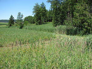
Matzenhauser Mahlweiher
|
"Matzenhauser Mahlweiher" nature reserve |
||
|
NSG "Matzenhauser Mahlweiher"
|
||
| location | Tettnang , Lake Constance district , Baden-Württemberg , Germany | |
| surface | 0.092 km² | |
| Identifier | 4,220 | |
| WDPA ID | 164584 | |
| Geographical location | 47 ° 41 ' N , 9 ° 39' E | |
|
|
||
| Setup date | April 1, 1993 | |
| administration | Regional Council Tübingen | |
The Matzenhauser Mahlweiher area is a nature reserve (NSG number 4.220) in the northeast of the Baden-Württemberg city of Tettnang in the Lake Constance district in Germany that was designated by ordinance of April 1, 1993 by the Tübingen regional council .
location
The approximately nine hectare Matzenhauser Mahlweiher nature reserve is part of the Westallgäu hill country. It lies on the south-eastern edge of the Arlenholz forest in the Tannau district , between the two districts of Obereisenbach in the west and Krumbach in the east, at an altitude of 500 m above sea level. NN .
Protection purpose
Essential protective purpose is to maintain a richly textured ecosystem consisting of a nutrient-poor slope Quellmoor with its most vulnerable flora from Kalkkleinseggenrieden as a habitat for many specially adapted insects - especially numerous day and moth species are, in turn, food as well as food for many species of birds, pipes Grass scattering meadows whose floristic biodiversity is a habitat for numerous insect species, especially for butterfly species and rams that are only native to there , wet meadows , as breeding and habitat for endangered meadow breeders and a wooded terminal moraine typical of this area , which increases the biodiversity of the area through its woody population.
See also
Web links
- Weblink of the State Institute for the Environment, Measurements and Nature Conservation Baden-Württemberg (LUBW)
Individual evidence
- ^ Ordinance of the regional council of Tübingen on the nature reserve "Matzenhauser Mahlweiher" from April 1, 1993 (Journal of Laws of May 14, 1993, p. 258)
Coordinates: 47 ° 40 ′ 56 ″ N , 9 ° 39 ′ 16 ″ E


