
Montlevicq
| Montlevicq | ||
|---|---|---|
|
||
| region | Center-Val de Loire | |
| Department | Indre | |
| Arrondissement | La Châtre | |
| Canton | La Châtre | |
| Community association | Châtre et Sainte Sévère | |
| Coordinates | 46 ° 35 ' N , 2 ° 4' E | |
| height | 207-263 m | |
| surface | 18.79 km 2 | |
| Residents | 115 (January 1, 2017) | |
| Population density | 6 inhabitants / km 2 | |
| Post Code | 36400 | |
| INSEE code | 36130 | |

Montlevicq is a French municipality with 115 inhabitants (as of January 1 2017) in the department of Indre in the Region Center-Val de Loire . It belongs to the arrondissement of La Châtre , the canton of La Châtre and the communal association Communauté de communes de la Châtre et Sainte Sévère . The inhabitants are called Lévicomontains .
location
Montlevicq is located about 45 kilometers southeast of Châteauroux on the Igneraie river . Montlevicq is surrounded by the neighboring communities Thevet-Saint-Julien in the north, Vicq-Exemplet in the northeast, Néret in the east, Champillet in the south and southeast, La Motte-Feuilly in the south and southwest, Briantes in the west and southwest, and Lacs in the west and northwest .
Population development
| year | 1962 | 1968 | 1975 | 1982 | 1990 | 1999 | 2006 | 2013 |
| Residents | 241 | 205 | 160 | 164 | 129 | 116 | 106 | 105 |
| Source: Cassini and INSEE | ||||||||
Attractions
- Saint-Pierre church
- Montlevicq Castle
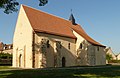
Saint-Pierre church

Montlevicq Castle


Personalities
- Jacques Auxiette (* 1940), mathematician, politician (PS)