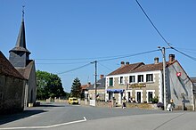
La Buxerette
| La Buxerette | ||
|---|---|---|
|
|
||
| region | Center-Val de Loire | |
| Department | Indre | |
| Arrondissement | La Châtre | |
| Canton | Neuvy-Saint-Sépulchre | |
| Community association | La Marche Berrichonne | |
| Coordinates | 46 ° 30 ′ N , 1 ° 48 ′ E | |
| height | 282-387 m | |
| surface | 10.99 km 2 | |
| Residents | 109 (January 1, 2017) | |
| Population density | 10 inhabitants / km 2 | |
| Post Code | 36140 | |
| INSEE code | 36028 | |
La Buxerette is a French municipality with 109 inhabitants (as of January 1 2017) in the department of Indre in the Region Center-Val de Loire ; it belongs to the arrondissement of La Châtre and the canton of Neuvy-Saint-Sépulchre (until 2015: canton of Aigurande ). The inhabitants are called Buxerettois .
geography
La Buxerette is located about 41 kilometers south-southeast of Châteauroux . Neighboring municipalities of La Buxerette are Cluis in the north and northwest, Saint-Denis-de-Jouhet in the east and northeast, Crozon-sur-Vauvre in the east and southeast, Aigurande in the south and Montchevrier in the west.
Population development
| year | 1962 | 1968 | 1975 | 1982 | 1990 | 1999 | 2006 | 2013 |
| Residents | 269 | 270 | 205 | 183 | 168 | 128 | 115 | 103 |
| Source: Cassini and INSEE | ||||||||
Attractions
- Saint-Mandé church from the 12th / 13th centuries century
Web links
Commons : La Buxerette - collection of images, videos and audio files

