Néret
| Néret | ||
|---|---|---|
|
|
||
| region | Center-Val de Loire | |
| Department | Indre | |
| Arrondissement | La Châtre | |
| Canton | La Châtre | |
| Community association | Châtre et Sainte Sévère | |
| Coordinates | 46 ° 34 ' N , 2 ° 9' E | |
| height | 219-282 m | |
| surface | 19.05 km 2 | |
| Residents | 191 (January 1, 2017) | |
| Population density | 10 inhabitants / km 2 | |
| Post Code | 36400 | |
| INSEE code | 36138 | |
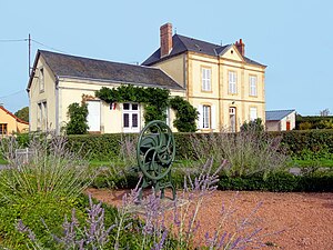
 Town hall (Mairie) of Néret |
||
Néret is a French municipality with 191 inhabitants (as of January 1 2017) in the department of Indre in the Region Center-Val de Loire . It belongs to the arrondissement of La Châtre , the canton of La Châtre and the communal association Communauté de communes de la Châtre et Sainte Sévère . The inhabitants are called Néretois .
location
Néret is about 50 kilometers southeast of Châteauroux . The municipality is crossed by the Igneraie river. Néret is surrounded by the neighboring communities Vicq-Exemplet in the north, Châteaumeillant in the east and south-east, Urciers in the south, Champillet in the south-west and Montlevicq in the west.
Population development
| year | 1962 | 1968 | 1975 | 1982 | 1990 | 1999 | 2006 | 2013 |
| Residents | 347 | 316 | 253 | 233 | 208 | 208 | 207 | 215 |
| Source: Cassini and INSEE | ||||||||
Attractions
- Saint Martin Church
- Rochepeau Castle
- Lavallas Castle
Web links
Commons : Néret - collection of images, videos and audio files


