
Lourouer-Saint-Laurent
| Lourouer-Saint-Laurent | ||
|---|---|---|
|
||
| region | Center-Val de Loire | |
| Department | Indre | |
| Arrondissement | La Châtre | |
| Canton | La Châtre | |
| Community association | Châtre et Sainte Sévère | |
| Coordinates | 46 ° 37 ′ N , 2 ° 1 ′ E | |
| height | 194-246 m | |
| surface | 11.21 km 2 | |
| Residents | 270 (January 1, 2017) | |
| Population density | 24 inhabitants / km 2 | |
| Post Code | 36400 | |
| INSEE code | 36100 | |
_-_Mairie.jpg) Town hall (Mairie) of Lourouer-Saint-Laurent |
||

Lourouer-Saint-Laurent is a French commune of 270 inhabitants (as of January 1, 2017) in the department of Indre in the Region Center-Val de Loire . It belongs to the arrondissement of La Châtre , the canton of La Châtre and the communal association Communauté de communes de la Châtre et Sainte Sévère . The inhabitants are called Oratiens .
location
Lourouer-Saint-Laurent is about 37 kilometers southeast of Châteauroux . Lourouer-Saint-Laurent is surrounded by the neighboring communities Verneuil-sur-Igneraie in the north, Thevet-Saint-Julien in the east and north-east, Lacs in the east and south-east, Montgivray in the south and south-west and Nohant-Vic in the west and north-west.
Population development
| year | 1962 | 1968 | 1975 | 1982 | 1990 | 1999 | 2006 | 2013 |
| Residents | 267 | 246 | 228 | 231 | 228 | 224 | 218 | 263 |
| Source: Cassini and INSEE | ||||||||
Attractions
- Saint-Laurent church from the 12th century, monument historique since 1987
- Old Town Hall
- Ars Castle from the 14th / 15th centuries Century, Monument historique since 1926
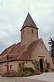
Saint Laurent Church

Old Town Hall

Ars Castle

_-_Ancienne_mairie.jpg)
_05.JPG)
Web links
Commons : Lourouer-Saint-Laurent - Collection of images, videos and audio files