
Montipouret
| Montipouret | ||
|---|---|---|
|
||
| region | Center-Val de Loire | |
| Department | Indre | |
| Arrondissement | La Châtre | |
| Canton | Neuvy-Saint-Sépulchre | |
| Community association | Marche Berrichonne | |
| Coordinates | 46 ° 39 ′ N , 1 ° 54 ′ E | |
| height | 170-259 m | |
| surface | 27.89 km 2 | |
| Residents | 556 (January 1, 2017) | |
| Population density | 20 inhabitants / km 2 | |
| Post Code | 36230 | |
| INSEE code | 36129 | |
 Town Hall (Mairie) of Montipouret |
||

Montipouret is a French municipality with 556 inhabitants (as of January 1 2017) in the department of Indre in the Region Center-Val de Loire ; it belongs to the arrondissement of La Châtre and the canton of Neuvy-Saint-Sépulchre . The inhabitants are called Porretimonastériens .
geography
Montipouret is located about 27 kilometers southeast of Châteauroux . The municipality is crossed to the north by the river Indre and to the south by its tributary Vauvre . Neighboring municipalities of Montipouret are Saint-Août in the north and northeast, Saint-Chartier in the east and northeast, Nohant-Vic in the east, Sarzay in the south, Tranzault in the southwest and Mers-sur-Indre in the west and northwest.
Population development
| year | 1962 | 1968 | 1975 | 1982 | 1990 | 1999 | 2006 | 2013 |
| Residents | 667 | 609 | 533 | 502 | 514 | 507 | 569 | 578 |
| Source: Cassini and INSEE | ||||||||
Attractions
- Saint-Martin church from the 12th century, monument historique since 1922
- Angibault mill from the 18th century
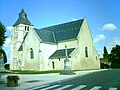
Saint Martin Church
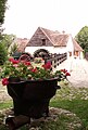
Angibault Mill


Web links
Commons : Montipouret - collection of images, videos and audio files