
Neuenlande
|
Neuenlande
Neenlanne ( Low German ) municipality Loxstedt
|
||
|---|---|---|
 |
||
| Height : | −1 m above sea level NHN | |
| Area : | 8.22 km² | |
| Residents : | 114 (Jun 30, 2019) | |
| Population density : | 14 inhabitants / km² | |
| Incorporation : | March 1, 1974 | |
| Postal code : | 27612 | |
| Area code : | 04740 | |
Location of Neuenlande in Lower Saxony |
||
 Neuenlande in the municipality of Loxstedt
|
||

Neuenlande ( Low German Neenlanne ) is a village in the unified community Loxstedt in Lower Saxony Cuxhaven .
geography
location
The place in the Osterstader Marsch lies east of the Weser , north of the Drepte and south of the Lune . To the west of the village is the Neuenlander Außenendeich nature reserve .
Neighboring places
| District land dignities | Schwegen | |
.svg)
|
Stotel district | |
|
Rechtenfleth (unitary community Hagen in Bremen ) |
(Source:)
history
Neuenlande was laid out as a street village and belonged to the Hagen district around 1768 and from 1852 to 1885 . An exception is the French era , when Neuenlande was assigned to the municipality of Dedesdorf . In 1840 the village became a rural community and the district of the same name was formed in 1876. The community belonged to the districts of Geestemünde and Wesermünde and was incorporated into Loxstedt on March 1, 1974 for regional reform in Lower Saxony .
The rural community of Neuenlande also included the Neuenlandermoor district, a bog colony that was created in 1801, but which was a separate district from 1876 to 1969, was renegotiated to Stotel and is now part of the Schwegen district (as part of the Stotel district) .
Population development
|
|
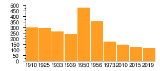
|
politics
City council and mayor
At the municipal level, the community of Neuenlande is represented by the Loxstedt municipal council.
Mayor
The mayor of Neuenlande is Gerd Keithan ( CDU ). The term of office runs from 2016 to 2021.
coat of arms
The design of the municipal coat of arms of Neuenlande comes from the heraldist and coat of arms painter Albert de Badrihaye , who designed around 80 coats of arms in the district of Cuxhaven.
|
|
Blazon : "In silver three of green , with an increasing silver moon occupied sign foot growing green ears of corn ." |
| Justification for the coat of arms: The ears of corn refer to the basic word "lande", the waxing moon is a symbol for the defining word "new". |
Culture and sights
Architectural monuments
Economy and Infrastructure
Public facilities
Together with the northern village of Büttel , Neuenlande has a multi-purpose hall with a sports field.
traffic

A bus line from Sandstedt to Bremerhaven runs several times a day through Neuenlande and Büttel. Furthermore, in the north-west, approx. 5 km away, is the Weser tunnel with access to Nordenham and Rodenkirchen . Neuenlande has access to the A 27 Bremen – Bremerhaven motorway via the Stotel junction.
literature
- Fritz Hörmann, Ude Meyer, Christian Morisse, Eberhard Nehring, Irmgard Seghorn, Egon Stuve, Else Syassen: Wesermünde field names collection - the field names of the property tax cadastre from 1876 . Ed .: Kulturstiftung der Kreissparkasse Wesermünde (= new series of special publications by the men from Morgenstern , Heimatbund an Elb- und Wesermuende eV Volume 27 ). Men from Morgenstern Verlag, Bremerhaven 1995, ISBN 3-931771-27-X , p. 16 ([ digital copy ( memento from October 26, 2007 in the Internet Archive )] [PDF; 431 kB ; accessed on October 23, 2019]).
Web links
Individual evidence
- ↑ a b Lower Saxony State Administration Office (ed.): Community directory for Lower Saxony . Municipalities and municipality-free areas. Self-published, Hanover January 1, 1973, p. 48 , Wesermünde district ( digitized version ( memento from August 7, 2019 in the Internet Archive ) [PDF; 21.3 MB ; accessed on June 3, 2020]).
- ↑ a b Population of the Loxstedt community. In: Website of the municipality of Loxstedt. June 30, 2019, accessed September 4, 2019 .
- ↑ Overview map of the Cuxhaven district. In: cuxland-gis.landkreis-cuxhaven.de. November 2016, accessed March 26, 2020 .
- ^ Federal Statistical Office (ed.): Historical municipality directory for the Federal Republic of Germany. Name, border and key number changes in municipalities, counties and administrative districts from May 27, 1970 to December 31, 1982 . W. Kohlhammer, Stuttgart / Mainz 1983, ISBN 3-17-003263-1 , p. 249 .
- ↑ Ulrich Schubert: Community directory Germany 1900 - Geestemünde district. Information from December 1, 1910. In: gemeindeververzeichnis.de. January 5, 2020, accessed March 26, 2020 .
- ↑ a b c Michael Rademacher: German administrative history from the unification of the empire in 1871 to the reunification in 1990. Wesermünde district ( see under: No. 65 ). (Online material for the dissertation, Osnabrück 2006).
- ↑ a b Statistisches Bundesamt Wiesbaden (ed.): Official municipality register for the Federal Republic of Germany - 1957 edition (population and territorial status September 25, 1956, for Saarland December 31, 1956) . W. Kohlhammer, Stuttgart 1958, p. 192 ( digitized version ).
- ↑ Population figures of the community of Loxstedt 2010–2013. In: Website of the municipality of Loxstedt. December 31, 2013, archived from the original on March 8, 2014 ; accessed on September 4, 2019 .
- ↑ Population figures in the Loxstedt community 2014–2017. In: Website of the municipality of Loxstedt. June 30, 2017, archived from the original on September 6, 2017 ; accessed on September 4, 2019 .
- ↑ Mayor of Neuenlande. In: Website of the municipality of Loxstedt. Retrieved April 11, 2019 .
- ↑ a b Landkreis Wesermünde (Ed.): Coat of arms of the Landkreis Wesermünde . Grassé Offset Verlag, Bremerhaven / Wesermünde 1973, ISBN 3-9800318-0-2 .
Bexhövede (with Nückel ) |
Büttel |
Thunder |
Düring |
Fleeste |
Hahnenknoop |
Hetthorn |
Holte |
Lanhausen | Loxstedt |
Nesse |
Neuenlande |
Schwegen |
Stinstedt |
Stotel
District Landwürden :
Buttel (Büttel) |
Dedesdorf-Eidewarden |
Maihausen |
Overwarfe |
Ueterlande |
Wiemsdorf